Updates on the Caldor Fire burning near the Lake Tahoe Basin in California’s Sierra Nevada.
2:45p PDT, 9/2
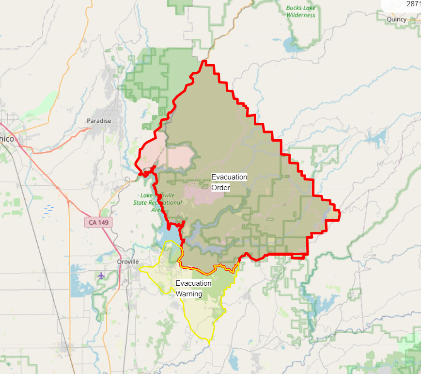
Up to 811 structures destroyed as crews were able to go in to some places and assess damage.
With better air conditions there have been more active air attacks on the fire throughout the day, especially in the Wrights Lake and Kirkwood areas.
Structure protection ongoing at Wrights Lake with the fire moving N/NE, into the Desolation Wilderness, though bounded on the east by the granite mastiffs of the Crystal Range.
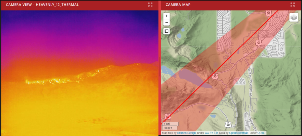
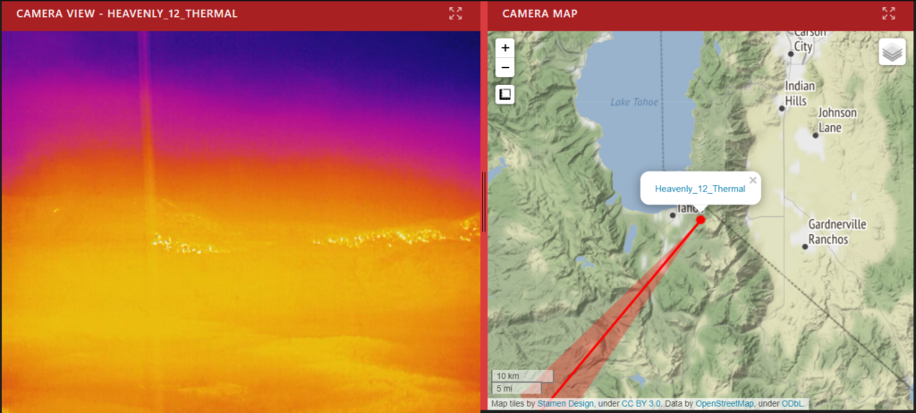
Northeast side of the fire has slowed though it is abutting, or at least close to, the Heavenly ski area.
Firefighters have constructed a dozer line on the fire’s northeast side to protect structures in South Lake Tahoe. They anticipate being able to hold that line.
Kirkwood structure protection a priority today as the fire is currently hung up on a ridge near the ski area.
7:45a PDT, 9/1
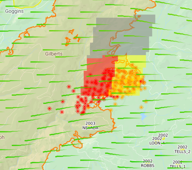
Fire is 204,390 acres and 20% contained. Rate of spread slowed yesterday despite the red flag conditions (continuing through tonight at 11p). 544 homes destroyed along with 12 commercial properties and 173 minor structures.
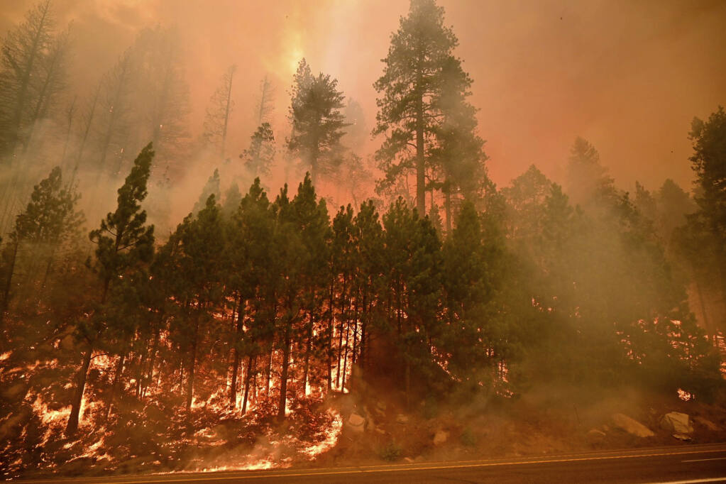
Caldor Fire continues to burn the east ridge of Christmas Valley, south of populated areas. So far there’s a distinct gap between two flanks of the fire where amazing work by firefighters has kept the inferno from burning along 89 to structures in Meyers.
Here’s another view of that gap.
Fire is about 2 miles from Heavenly ski resort. Firefighters hope to move it around Heavenly should the fire approach it. Snow making machines – used previously to protect Sierra-at-Tahoe – will play an important role in such efforts.
With the #CaldorFire on the move, there’s concern it could reach Heavenly. It’s why the ski resort is taking a defensive stance, shooting off these water cannons to protect equipment from a fire, that tonight, is just four miles away and burning this direction. More at 10 @FOX40pic.twitter.com/KwADDAxIoz
Earlier air attacks featuring retardant lines holding the fire by Kirkwood. Some spots by Kirkwood Lake, but “within objectives.”
#CaldorFire (El Dorado Co/ENF) – AA did recon of the area by Kirkwood – said fire is still mostly hung up in the retardant from the operation earlier today – mentioned by Two Sentinels. Lots of spots by Kirkwood Lake but said that those seem to be within objectives.
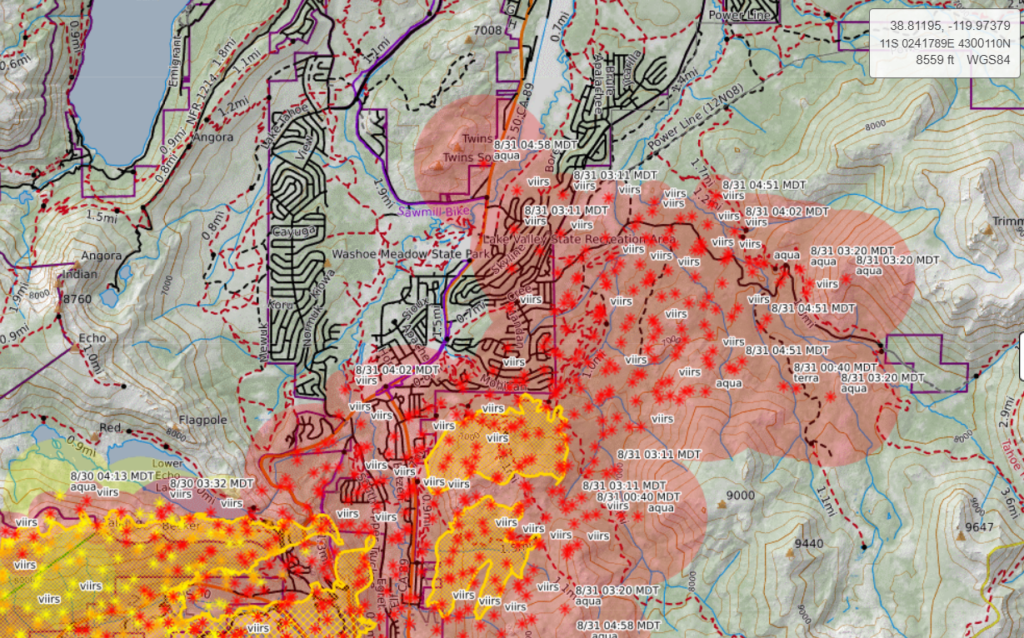
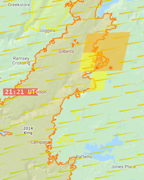
Winds picking up, blowing embers from the fire – which is burning up ridges east of 89 into the Carson Range – into Meyers where ground crews are putting them out as they land on roofs or start spot fires.
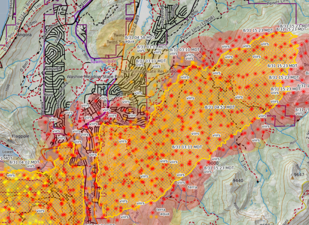
9:00a PDT, 8/31
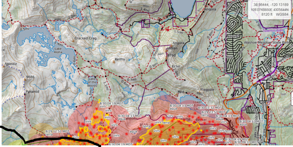
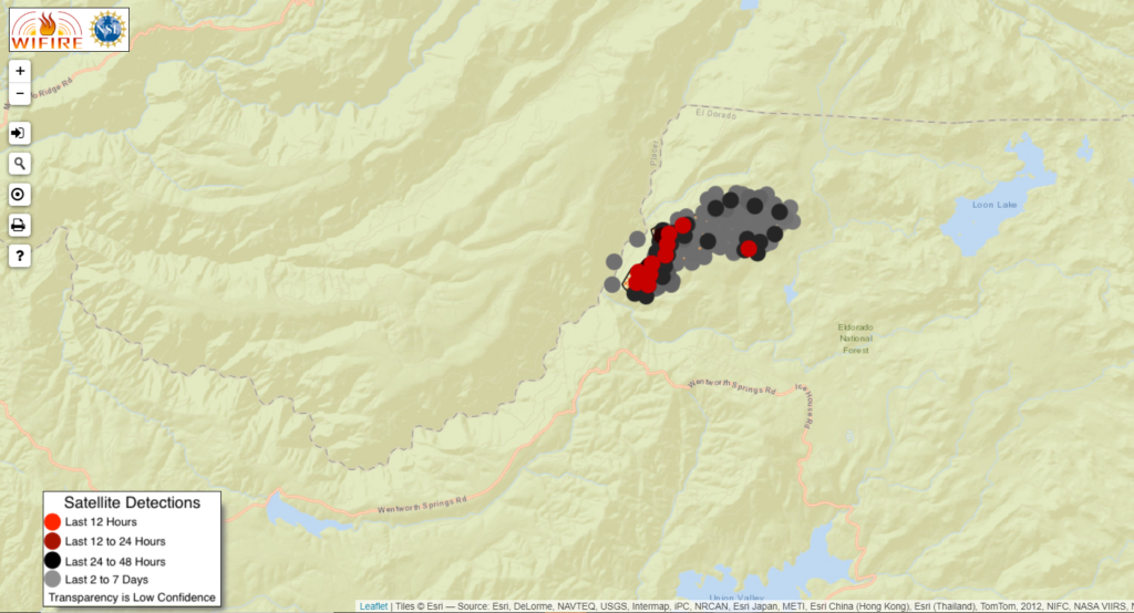
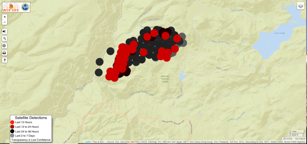
Satellite heat detection has the fire SE of Meyers burning along a forested ridge close to the neighborhood.
9:45p PDT, 8/30
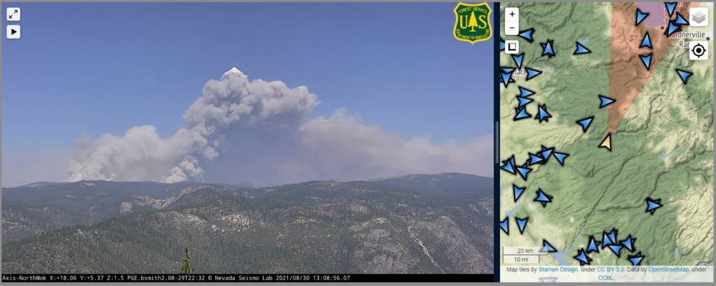
Fire pretty firmly established in Christmas Valley and the Tahoe Basin.
Fire has spotted into Christmas Valley, heading towards Highway 89.
Video of spot fire that has breached Tahoe basin in Christmas Valley. This is 89 looking east. About half a mile from homes and Caltrans maintenance station. @ABC10#CaldorFire expect more spot fires. winds carry embers 3/4-1 mile with wind gusts. Dozers & hand crews mobilizing pic.twitter.com/KWKmvcVkoW
Some good news from the community briefing: After a firefight 36-48 hours ago, there is no known structure loss at Strawberry.
North side of the fire is slowing due to sparser fuels. Presumably this refers to the crawl up Ralston Ridge last night and the spot fires near Lake Aloha.
1:50p PDT, 8/30
Fire is in the Tahoe Basin, currently hung up on the ridges. There are spots in the Desolation Wilderness by Lake Aloha (last night the fire was spotting to and over Ralston Ridge) and around Lower Echo Lake.
#CaldorFire (El Dorado Co/ENF) – @CALFIRE_CHIEF in press conference: fire made a 20,000 acre run yesterday, the biggest in the last week & a half. Fire has reached the basin but is hung up on the ridges w/ spots around Lower Echo Lake + Lake Aloha in the Desolation Wilderness.
Red Flag warning now in effect through 11p Wednesday (this has been extended). Covers Dixie and Caldor Fires. Winds blowing right into South Lake Tahoe.
⚠️Red Flag Warning now in effect and has been extended 🚩
🕚 Now – 11pm Wednesday 📍 N. Sierra & S. Cascades 💨Gusty winds & extremely dry
Update from Sierra-at-Tahoe, provided by a Sacramento Bee reporter.
Firefighters Saved Sierra at Tahoe resort, with only a vehicle maintenance building burning Sunday night in the Caldor fire. Up Highway 50 toward Echo Summit, the main lodge at adventure mountain sledding area also was intact.. pic.twitter.com/CHllzy1D5f
Spot fires in the Desolation Wilderness (boundary drawn in black). Fire climbed Ralston Ridge overnight and is heading towards Ralston and Tamarack Lakes. There’s obviously a lot of granite in Desolation, but still plenty of forests for runs or spotting, especially given how well it has threaded granite before.
Reports of one structure loss (potentially a parking garage) at Sierra-at-Tahoe. Otherwise the resort seems okay.
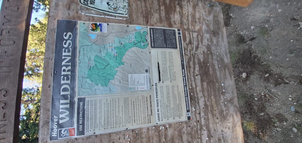
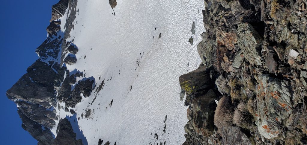
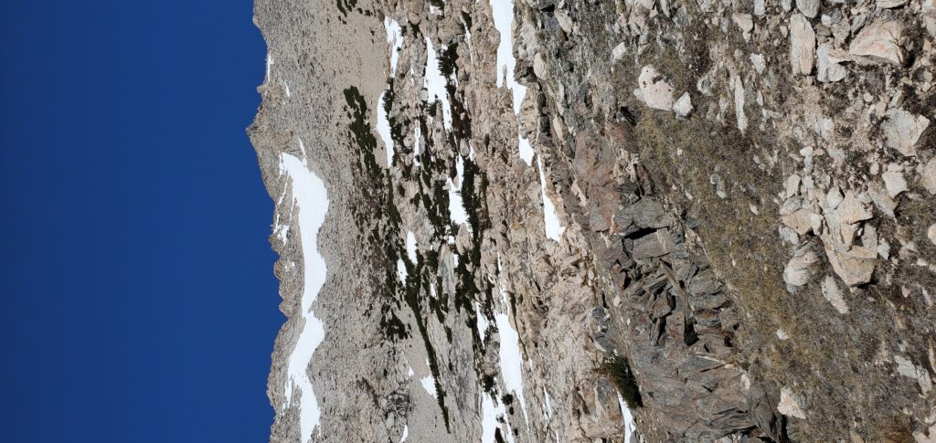
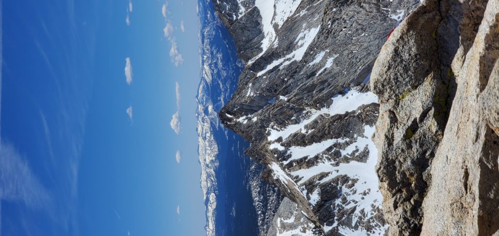
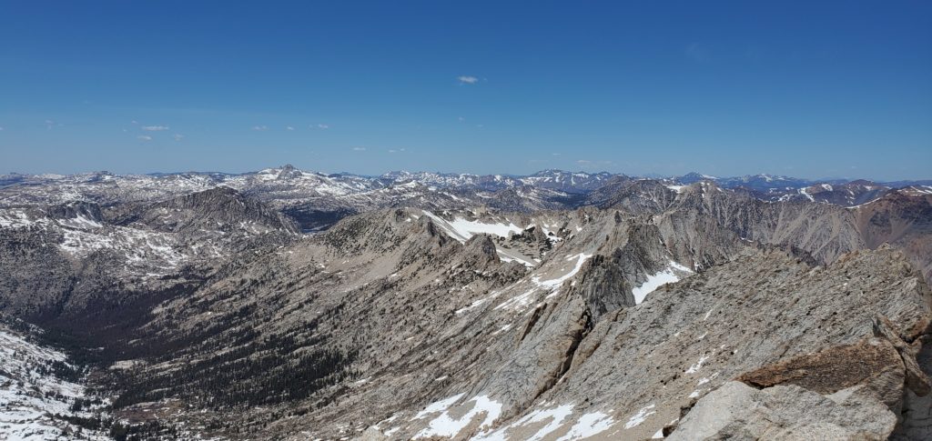
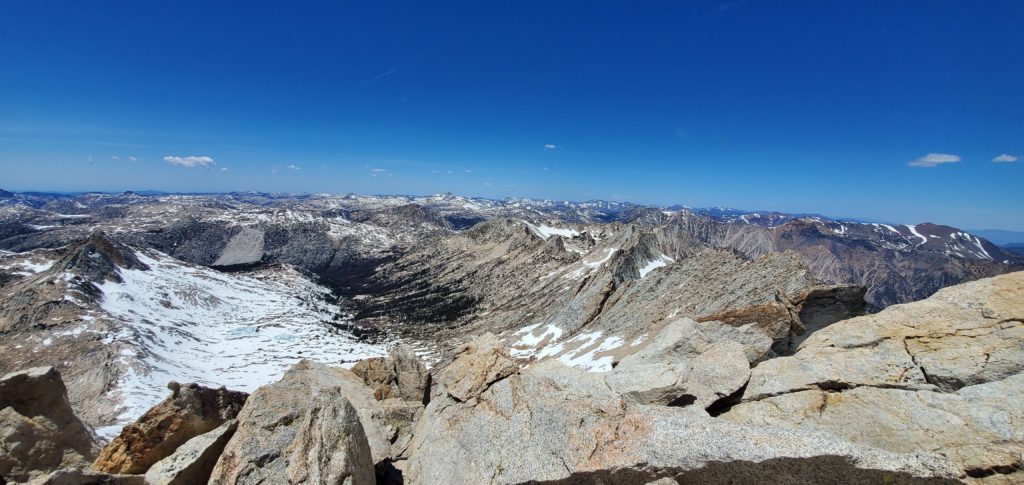
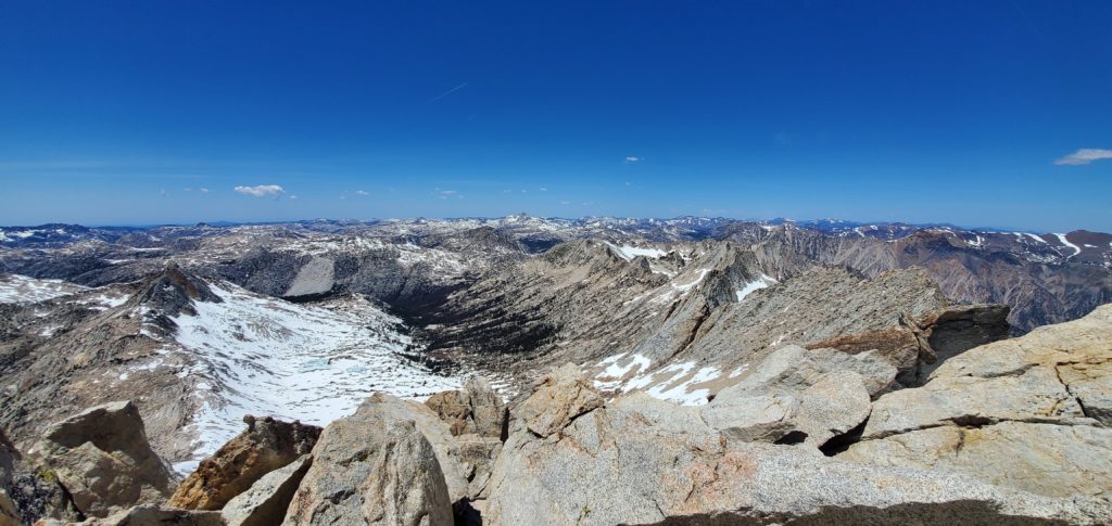
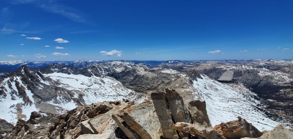
Trip report for Matterhorn Peak in California on May 30, 2021.
Result: Summited Matterhorn Peak
Class: 2
Rating: 2/5
Horse Creek Trail from Upper Twin Lake
I got to Annett’s Mono Village around 6:20a, hopeful to conquer my first Emblem Peak and tired from a terrible night of sleep at a motel in Walker and still sore from my first foray into the Sierra since September 2019 (a thunderstorm had dashed that previous day’s hopes of summiting Highland Peak in the Carson-Iceberg Wilderness area).
There are a couple parking lots available at the resort, with the hiker’s lot the furthest along the main road, keeping straight past the marina and ignoring the camping turn to the right. Some confusion about parking permits: Their booth says every car needs a permit, but they don’t open until 8a and have no self-service. I didn’t get a permit or, thankfully, a ticket.
A little after 6:45a I hit the trail. This too is a bit confusing at first as there are multiple paths through the marshy area where Horse Creek Trail meets Upper Twin Lake. I initially took the wrong path, which petered out into brambles. The correct trail, I believe, is the first right from the path that leads through the RV lot – it’s a bigger path than the others. While the AllTrails app doesn’t show it connecting to the Horse Creek Trail, it does so via a bridge that spans the creek.
From there route finding is straightforward until you get to the first headhall.
The switchbacks on the lower part of the trail, like all switchbacks, are agonizing. They gain very little elevation in too many miles. Long, swooping, needless. It’s easy and, in the early morning, alternated between cool shade and the warming sun poking through tree cover. Bob Burd (and others) have taken shortcuts by sticking next to Horse Creek. I’ll probably do that when I return to summit Whorl.
Horse Creek brings a nice melody to the trail until you pass the falls. Then the stream quiets and still settles on the valley with the sun blocked by the left ridge. It’s all quick: I knocked out the first four or so miles in less than 80 minutes. The Sawtooth Range looms high ahead, a reminder of the climbing to come.
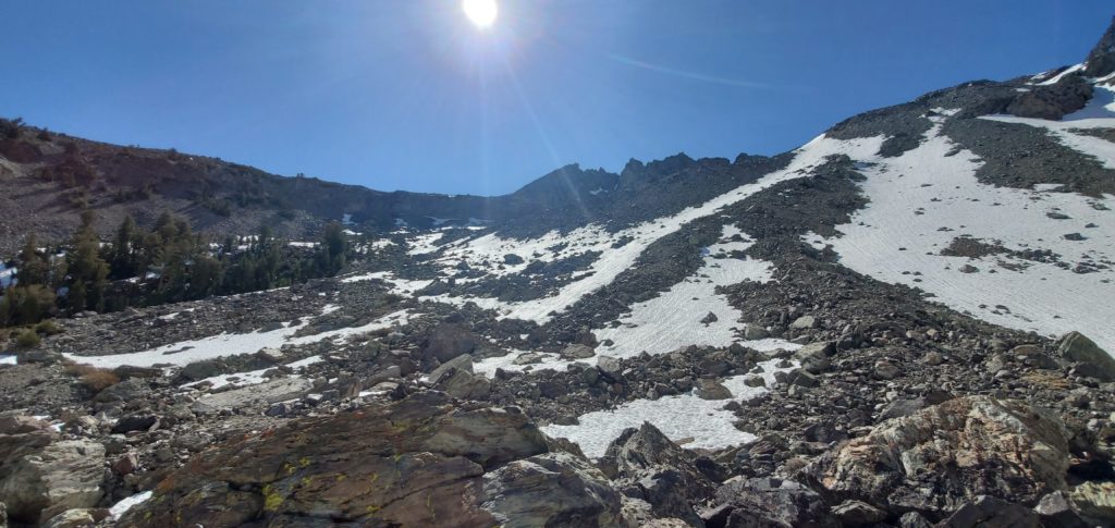
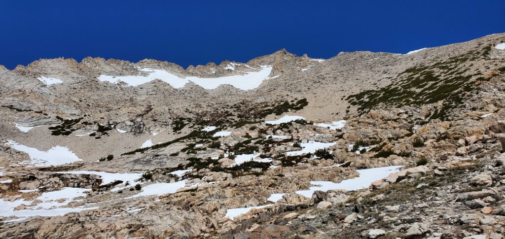
The trail gets a little more interesting as the trees break some and you go through rocks and some brush. But the real slog begins around 9600 feet.
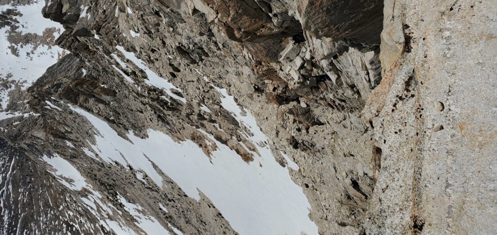
Here, in early season even in a low snow year, large patches of it cover parts of the trail, making adherence difficult especially as there are a number of use paths that wind over the rocks.
This is where I made my first route finding decision that slowed me down. Rather than go straight up the fairly firm snow patches – low enough angle and probably soft enough for kick-stepping; crampons, which I had, would’ve made those patches a breeze – I opted to route through the boulders on the left of the snow banks.
These rocks, glacial deposits mixed with fall from the sharp canyon sides, are every bit as annoying as you can imagine. Uneven hopping on unstable boulders that simply takes time and needlessly works legs. Given comfort and equipment, I’d take the snow.
After the first sharp elevation increase, there’s a brief plateau and still hundreds of feet above you, Horse Creek Pass. There’s lots of running water for refills and, on May 30, safe snow pack to cross the stream any time you want.
As the rise began again, I alternated between boulders and traverses on the snow, though generally using boulders for elevation gain. This section is steep and windy and none too pleasant, though a walk in the park compared to the SE slope.
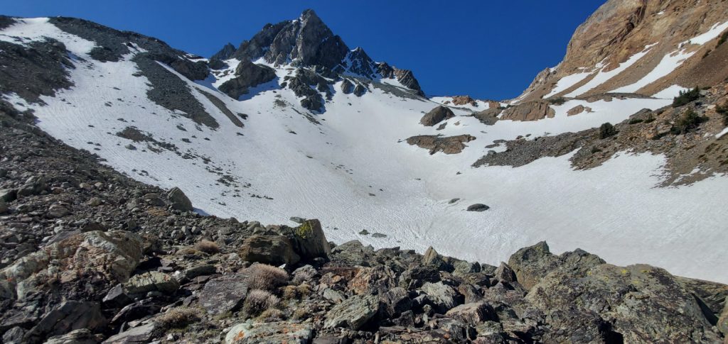
On final approach to Horse Creek Pass, AllTrails recommends taking a route high to the right of the pass. This bypasses the largest and probably steepest snow bank that goes straight over the pass and continues on Horse Creek Trail, a path you’d follow to get, eg, to Whorl Mountain. Following the AllTrails route immediately leaves you on the talus and scree SE slope of the Matterhorn.
I was having problems with my AllTrails app and ended up going straight over the pass, donning my crampons – unnecessarily, the slope wasn’t as steep as it looked, the snow was in fine condition for kick-stepping, and the runout was great if I did slip – for the last snow field. From there, I continued a bit over the pass before seeing a group of three hikers up on the scree to my right. Oops. I needed to backtrack and find a route to that slope.
This little detour, plus the earlier imperfections, added maybe 500 feet of climbing to the hike (5,700 feet of elevation gain, per Strava, versus the 5,280 usually associated with the effort). It also delayed me by 30-45 minutes. Not a big deal; I had plenty of time ahead of me.
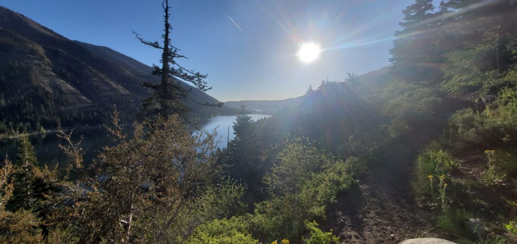
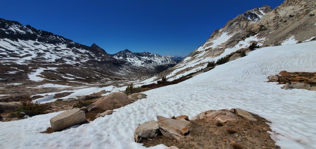
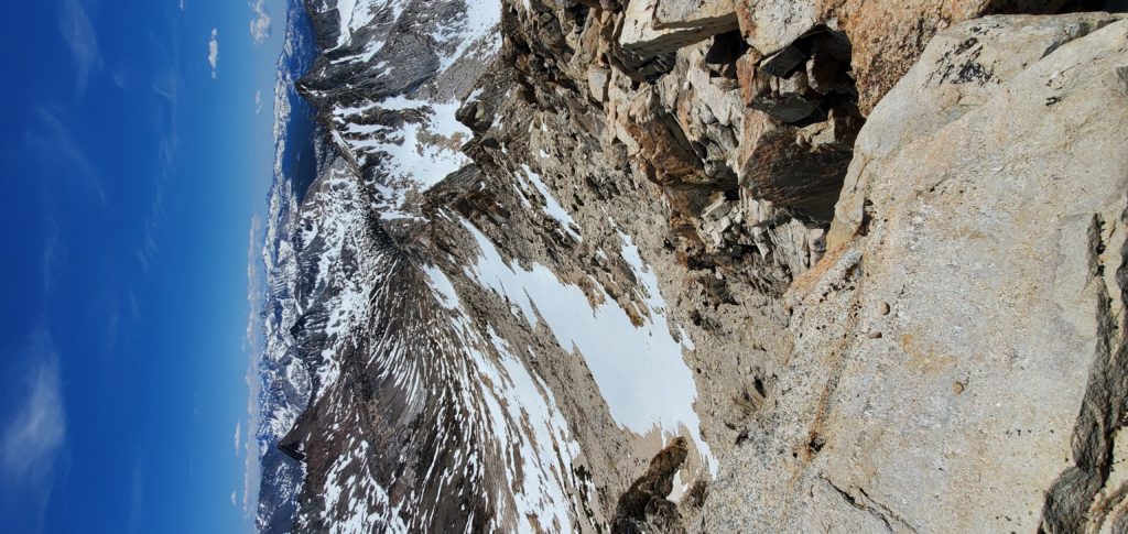
The view past Horse Creek Pass
Here the hike devolves into tedium. There’s roughly 1,400 feet of elevation gained in less than a mile on a scree slope. The views are pleasant but the terrain so annoying that it makes the hike rather miserable. It didn’t help that I had back-to-back nights of 4 hours of sleep, had only gotten to 9,400 feet the day before, and had best trained in the Flat Nothing Land of Chicago by running up and down high school bleachers with an N95!
As the slog continued, I definitely felt the affects of altitude. I had to stop every handful of steps, the scree slippage draining my sore legs and my breath needing to catch. Though I didn’t get a headache, my mind felt a bit fuzzy from want of sleep, altitude, and being annoyed.
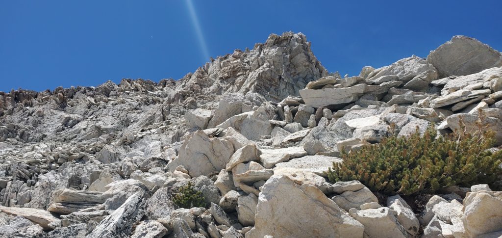
This continues for a while. Matterhorn Peak finally emerges to the left as the scree firms a little. There was one almost sketchy snow field that had a horrendous runout and steep slope. However, there were many boot prints to follow, a number of them having postholed 6+ inches, so the risk was very low. I put my crampons on just in case, though I definitely did not need them (and did not wear them on descent).
At this point, the route is supposed to assume some fun Class 3 scrambling. I’d hardly call it Class 3. There are no needed technical moves and most of the exposure is only 20-30 feet. Nothing feels sketchy; it’s straightforward scrambling on solid rock. Even coming down it’s easy. Honestly, I had hoped for more fun, something to make my hands sweat.
At 12:10 I reached the summit.
The summit block actually has exposure – you can look down a hundred feet in three directions. But there’s nothing technical in getting to or walking around the summit. The register is box is older and hard to get the lid on or off.
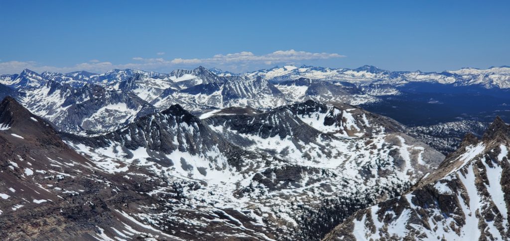
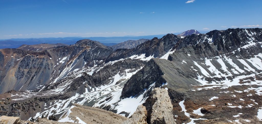
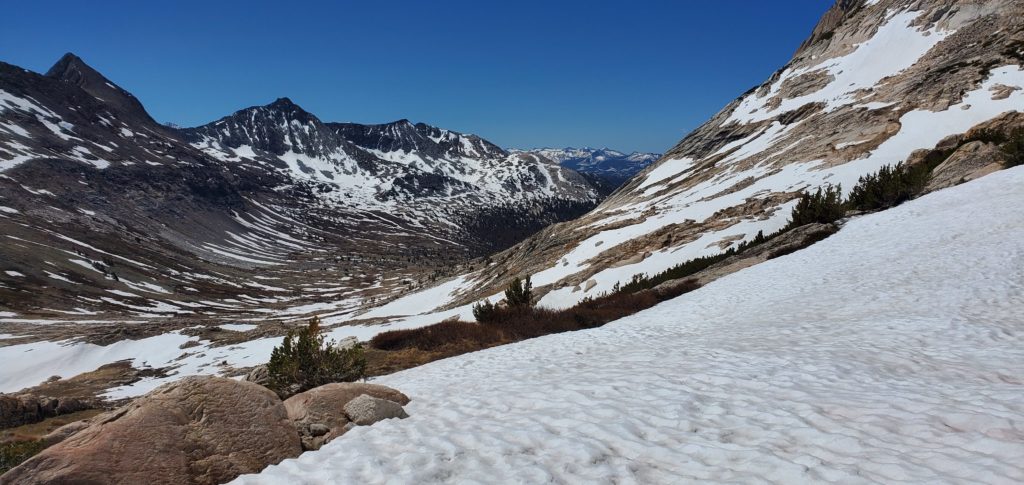
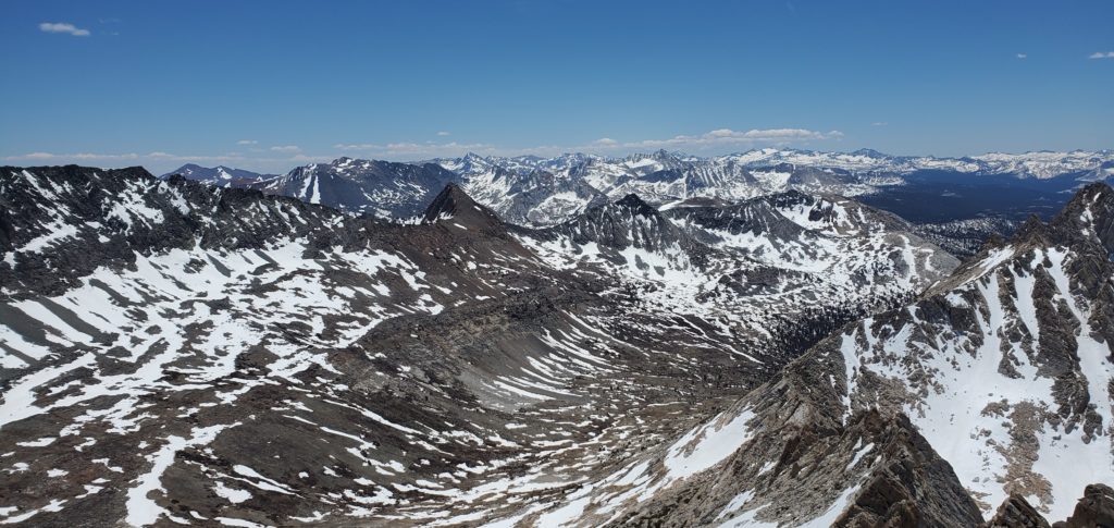
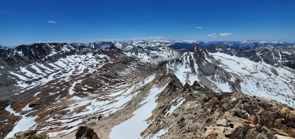
Views are magnificent, especially on a clear day. You can see to the Coast Range’s highest peaks in the west, Lyell and McClure to the south in Yosemite, Ritter and Banner, the Mammoth Crest, and so on. I’m less familiar with the subranges to the north, but the views there are spectacular, too. The glacially carved canyons below are stunning, as is the rest of the Sawtooth Range with Whorl looking tantalizingly close.
I stayed on the summit for about an hour, chatting with some folks who started at 4:30a and then a couple who started at the same time I did. All great people enjoying a beautiful day.
After nearly an hour, I left the summit and began the return trip.
Downclimbing the Class 3 section is straightforward. Good grips, nothing technical, little fear of falling into the exposure. I’m still not used to how my pack changes my center of gravity. That was the hardest part of heading down.
I scree-skied the slopes down, kicking lots of debris and losing elevation many times faster than I gained it, the one benefit of those slopes, and took the correct, high path through Horse Creek Trail. Here, again, it’s largely staying above the central path through the pass. The trail alternated between rock and snow, more rock up high and snow as the descent continued.
From here, route finding did become difficult as I wanted to stay true to the trail, seeing if it was easier than coming up off it. This isn’t strictly necessary: Point-and-shooting downhill will get you to the same place in probably the same time. I was just curious and exhausted. Having the trail think for me would be a nice mental break.
Of course, with the snow covering most of it, I had to keep checking AllTrails for my adherence, which got fairly annoying to keep looking at the device every couple dozen steps. Oh well. Following the trail did make things pretty easy. I got to glissade down a couple snowbanks in wonderful condition for arrests. Definitely the highlight on the way down. Sticking to the trail also kept me off most of the annoying rock and made the descent so much more pleasant than the steep boulder hopping on the way up.
Once on flatter terrain the trail still loses itself in rocks and brambles but always emerges after twenty feet or so. Following Horse Creek will always keep you on the right path.
By now I was dead exhausted and just wanted to sit down in the car. But the switchbacks kept coming and coming and coming, highlighting their inefficiency and teasing nature. They would be easy to run down, though.
At about 4:50p I returned to the resort. Overall it took just shy of 10 hours with 5.5 for the ascent and 3.5 for the descent (1 on the summit). Better route finding, slightly better strength, and better acclimation probably could have shaved an hour off the ascent time.
In the end, this was a pretty tedious hike not worth repeating. I imagine the East Couloir presents a more enjoyable ascent and better challenge. Even the stunning views could fully offset the slog it took to get there.
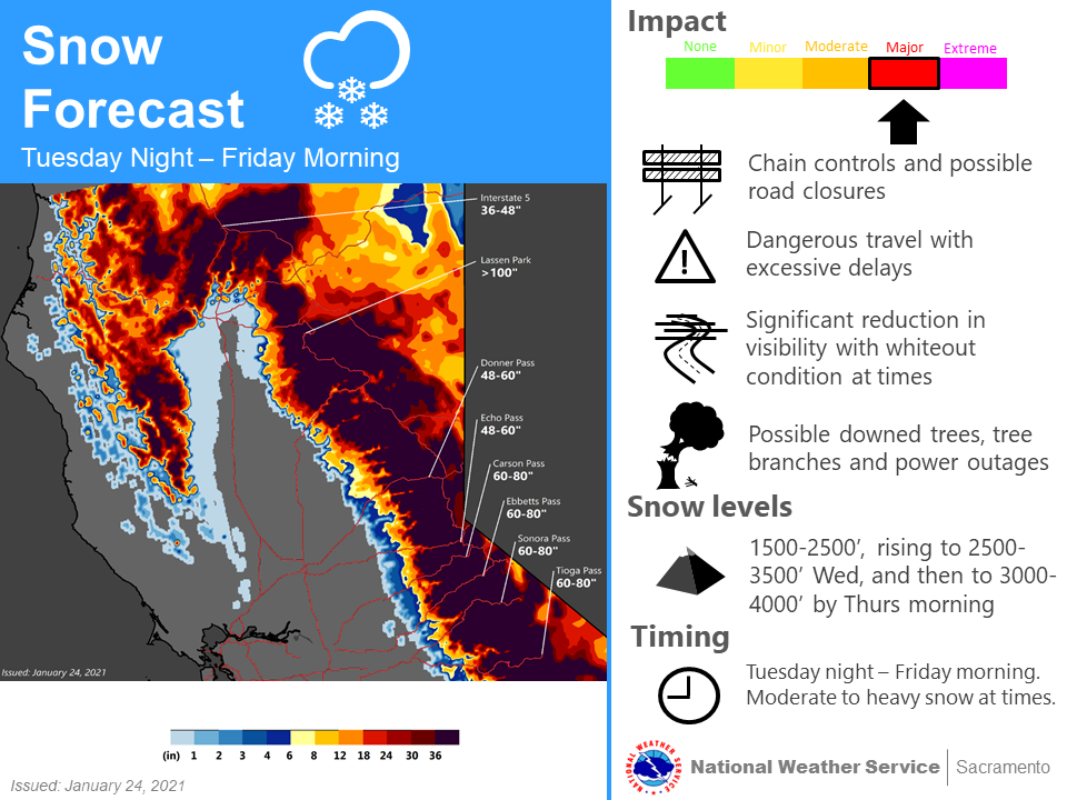
The above image, courtesy of the National Weather Service Sacramento office shows the expected snow totals from the upcoming atmospheric river, drenching the state from Tuesday night through Friday morning. Needless to say, it’s a lot, especially on the heels of record dryness that prompted elevated and critical fire conditions in mid-January.
In fact, should the storm hit those snow at the Sierra passes, it will single-handedly push snow depth well past the various averages for January 29, according to daily SNOTEL data for Donner Pass, Echo Pass, Carson Pass, and Ebbetts Pass from roughly 2004 to 2020.
Tabular data below. Raw snow depth (now snow-water equivalencies) in inches. Storm number takes the lower end of the forecast.
Donner Pass
Snow Depth
1/24/2021
32
Storm
48
1/29/2021
80
Average
57
Echo Pass
Snow Depth
1/24/2021
37
Storm
48
1/29/2021
85
Average
60
Carson Pass
Snow Depth
1/24/2021
29
Storm
60
1/29/2021
89
Average
57.25
Ebbetts Pass
Snow Depth
1/23/2021
31
Storm
60
1/29/2021
91
Average
60
There will also be some smaller snowfall coming in the next 7-10 days before the likelihood for looming dryness returns. Obviously, the next few days will be crucial to overcoming the current snowfall deficit.
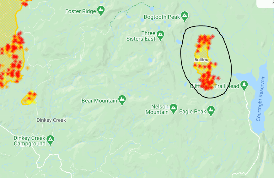
10:45p: Still 900 acres. From the incident page: Planned actions in this period will be to recon and identify primary, alternate, and contingency lines. Construct, strengthen and improve control lines. Protect cultural threatened and endangered resources using a safety first approach.
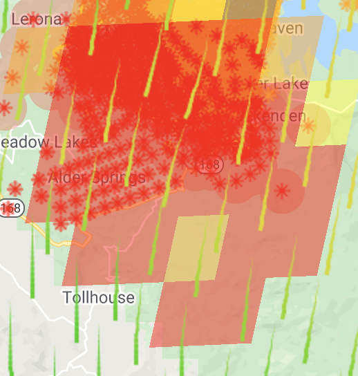
8:30a: 900 acres with 20 firefighters on it and 0% containment. Full containment expected October 20. Burning west of Courtright Reservoir on the eastern edge of the Dinkey Creeks Wilderness. This is separate from the Creek Fire and one of its spot fires near the west side of Dinkey Creek.
The Bullfrog Fire is burning in timber, understory litter, brush and short grass. Active fire behavior has been observed with running, short crown runs and spotting.
Firefighters are using a confine and contain strategy taking advantage of trails, natural features, and hand crews to fully suppress it.
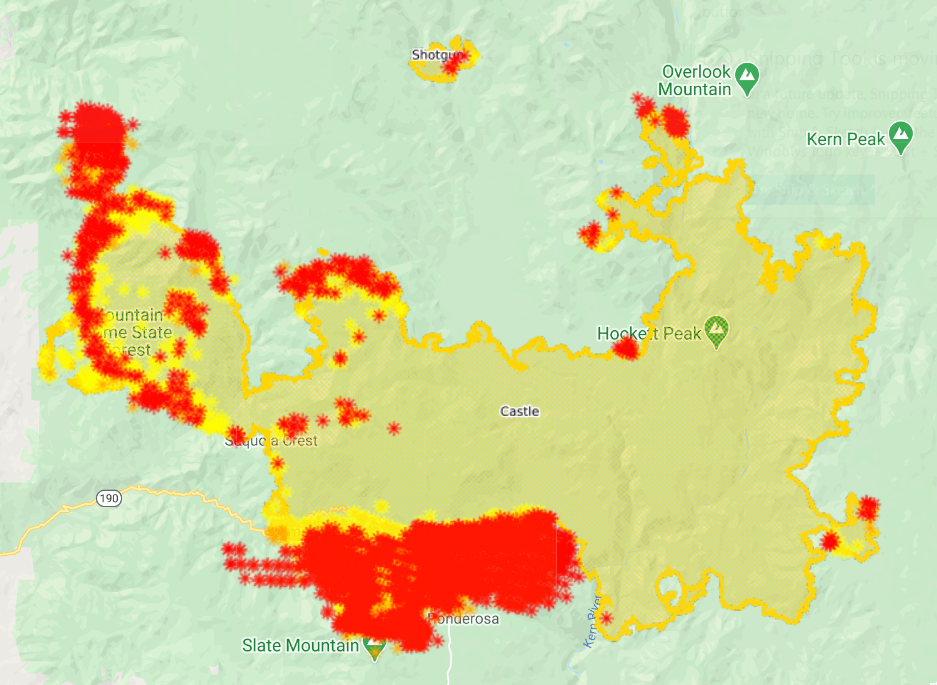
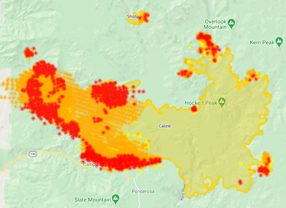
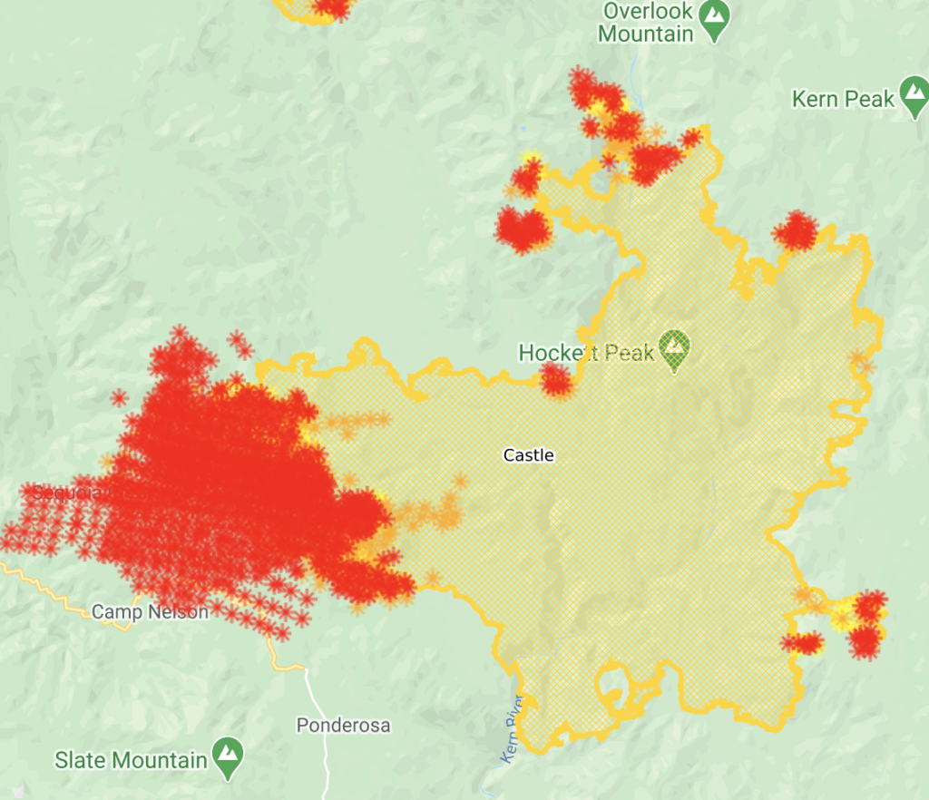
East Castle Zone SQF Complex – Castle Fire: For over a week, all resource efforts were focused on the defensive tactic of providing structure protection. However, for the past two days, crews have been able to refocus efforts on constructing containment lines near the fire’s perimeter.
Today, work will continue in the areas near Ponderosa with the construction and improvement of containment lines to create a buffer around the community. Crews will provide structure protection as the potential for spot fires still exists. In Camp Nelson, firefighters will be patrolling the area looking for hot spots in an effort to eliminate threats from latent heat sources. Around the Tule Indian Reservation, crews will widen and improve containment lines.
Crews will also continue to patrol the communities in and around Alpine Village, Sequoia Crest, Cedar Slope, as residual heat sources remain a threat. Several fires, caused by blowing embers have been discovered and extinguished by patrolling crews as fire began to ignite exterior features of structures.
With no movement on portions of the southern and eastern flanks of the fire, containment remains at 33%. Air resources will continue to monitor these areas. On the northeast point, the fire continues backing to the west and is now one mile from Sequoia National Park. Backcountry structure protection groups remain ready to respond in the Casa Vieja Meadows area and direct line construction will continue in the Little Horse Meadows area.
Forecasted weather today brings the potential for active fire behavior on the entire perimeter. This will include surface fire activity with moderate rates of spread, single tree and group tree torching with spotting up to 1/2 mile.
Fire movement will primarily be on the southern end of the fire from Camp Nelson to the Kern River. Residual heat from the initial fire front continues to impact the communities of Cedar Slope, Alpine Village, Jordan Peak, and Sequoia Crest. Threats to structures/infrastructure include Peppermint Work Center, Camp Nelson, Pierpoint,Ponderosa, Rogers Camp, Mountain Aire, and the Tule Indian Reservation.
The east side of the fire continues to threaten infrastructure and physical assets at Osa, Beach, Casa Vieja and Beck Meadows as well as the US Geological Service seismic station, The Blackrock Ranger Station, and other infrastructure in the area. The cultural resources on Monache Mountain and in Monache Meadows will also be threatened. The fire in the Kern River Canyon on the north side will continue to threaten the Kern Canyon Ranger Station, private in-holdings and the Sequoia National Park. Overall fire growth is predicted to be the similar as the last 12 hours.
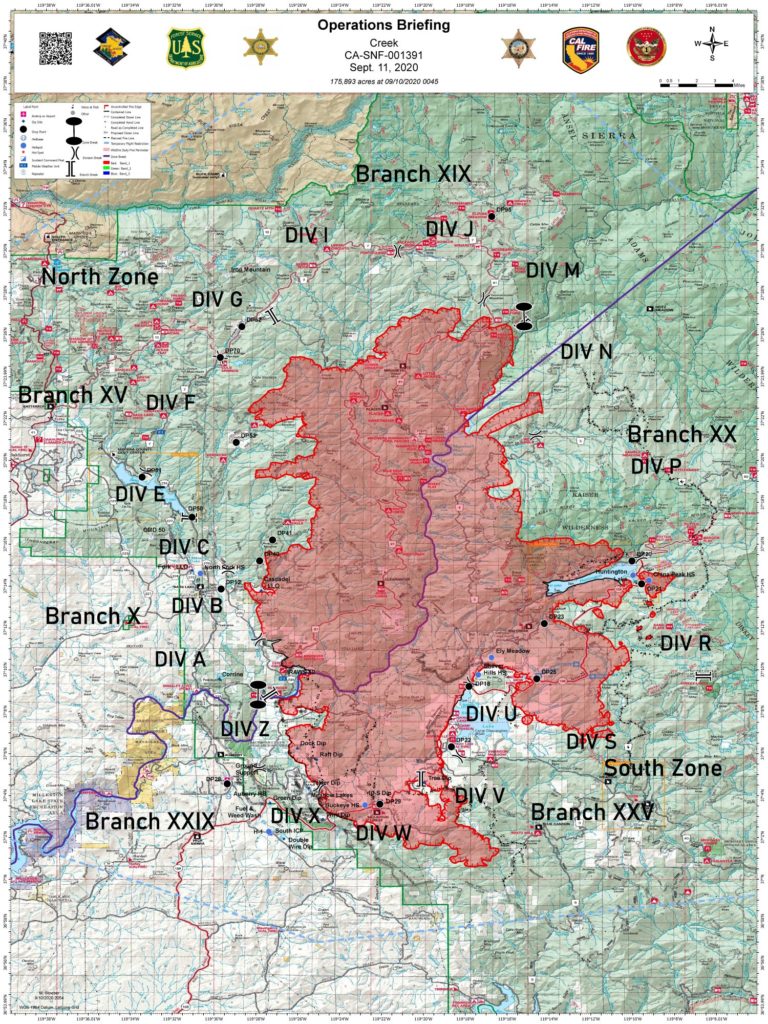
September 17
10:30a: 123,000 acres, still 12% contained. 150 structures destroyed and 3,500 threatened. 14 injuries and 3,000+ evacuated.
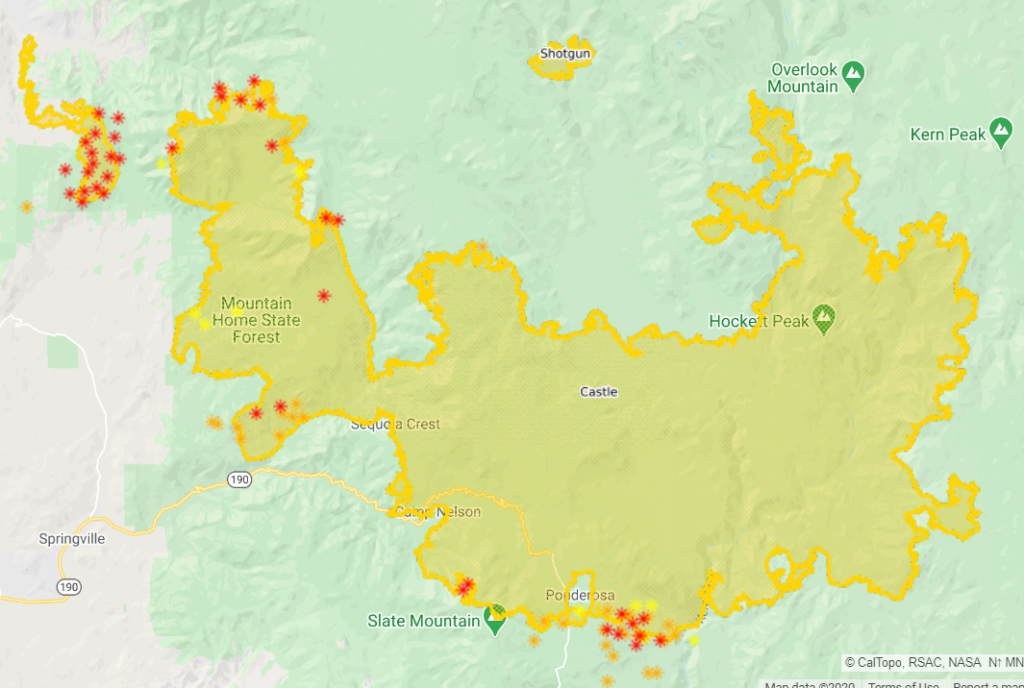
SQF COMPLEX-ALL ZONES: The entire complex is a total of 122,835 acres and contains the Castle Fire (122,011 acres) and the Shotgun Fire (824 acres), The complex is currently 12% contained.
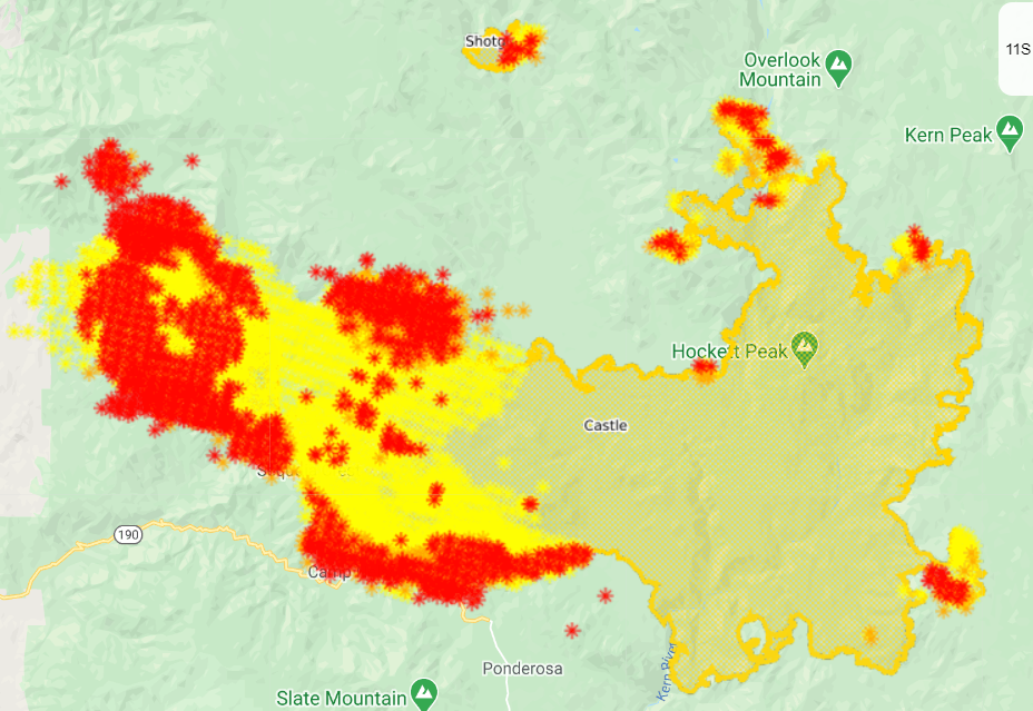
East Castle Zone SQF Complex – Castle Fire: Point protection of structures in all communities will continue to be the top priority in the upcoming days and nights. The southwest corner of the fire has continued to experience active fire behavior through the night and early in the day, due to extremely low humidity levels during the day and poor overnight humidity recoveries. Firefighters are working night operations to provide as much protection for area communities as they are able.
Yesterday, the fire ran towards Ponderosa from the northwest and northeast, with multiple spot fires. Firing operations were used to increase a black defensive line around Ponderosa. In Quaker Meadow, the fire spotted south as it moved toward Peppermint. Active fire is on both sides of highway 190.
If conditions are appropriate Today, burnout operations will be implemented on the east side of Ponderosa.
Structure protection in the Kern Canyon Ranger Station area has been turned over to local fire personnel in Sequoia National Park. Further southeast, there was a ten-acre spot fire near Little Horse Meadows. Firefighters worked through the night to secure the area. Today, they will continue working direct near Lion Meadows to secure this fire finger.
East Castle Zone SQF Complex – Shotgun Fire: The fire continues to exhibit low intensity surface fire and is currently 824 acres.
Weather: An upper level disturbance will begin to move across the fire which will bring southwest winds and an increase in clouds. High temperatures will range from 80-89 degrees and humidity levels will be as low as 7-10%.
Castle Fire: The western flank continues to be the top priority and is still exhibiting active fire behavior. Yesterday, a large spot in Jenny Creek caused additional evacuations northwest of the fire area.
On Monday, crews continued work on constructing indirect line from Quaker and Aspen Meadow south to the Kern River. The fire has crossed 190 near Cedar Slope in multiple areas. Through the night, firefighters worked in Doyle Springs.
Today, crews will continue to gather situational awareness and work to put together a plan from south of Cedar Slope to Coy Flat. Structure protection is being enacted for local communities, with point protection and defense being the priority.
Crews are preparing for the fire’s likely movement towards Ponderosa and Camp Nelson, and to maintain the viability of 190. Crews continue to make progress on the eastern finger of the fire between Little Horse Meadows and Lion Meadows. Despite additional growth on that area, crews are still able to construct direct line.
Structure preparation on the eastern flank of the fire is nearly complete, and crews plan to wrap up structure protection north around the Kern Canyon Ranger Station. Aerial resources continue to be used heavily on the fire with 237,000 gallons of retardant being dropped on Sunday, September 13th
September 14
11:10p: 101,000 acres (+10,000), 12% contained (unchanged). Lots of air activity today with VLATs aggressively defending communities.
Fire is burning hot tonight.
Poor relative humidity recoveries, warm temperatures, very low minimum relative humidity, atmospheric instability and winds produced critical fire behavior primarily to the west. The fire will continue to impact the Freeman Creek Giant Sequoia Grove, structure in the Pyles Boys Camp area, communities of Sequoia Crest, Alpine Village, Camp Nelson, and Cedar Slope. It will also impact the Mountain Home State Forest, The highway 190 corridor, USFS facilities and infrastructure in the area. The fire will threaten the community of Springville, Sequoia / Kings Canyon National Park, as well as structures scattered along the west slopes.
The East Flank of the fire will continue to threaten the Blackrock Ranger Station and other USFS facilities, as well as the cultural values and resources in the Monache Meadows area.
The north flank will continue to threaten the Kern River Ranger Station, Quinn Patrol adjacent private land and the Sequoia / Kings Canyon National Park.
Thanks for reading! If you’re interested in supporting the work that goes into providing these updates, please visit https://www.buymeacoffee.com/rs44. I really appreciate your generosity.
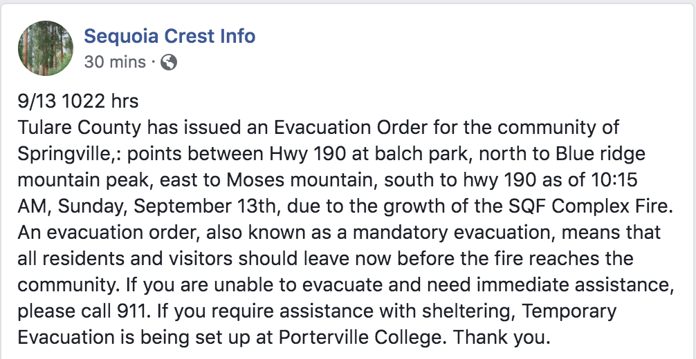
3:15p: Three Rivers now under mandatory evacuation order. Voluntary evacuation warning in Springville.
9,200 acres of giant sequoia have now burned. Fire is part of the ecosystem, but high severity fires destroy rather than rebirth.
Huge air activity over the fire, including the 747 tanker. Seems to be focused south of 190, between Camp Nelson and Quaker Meadow.
11:10a: Cost so far: $21.3 million. 12 injuries, 1,600+ structures threatened. 62 have been destroyed. Nearly 3,500 have evacuated.
The fire is currently 1.5 – 2 miles west of Mountain Home. Fire activity began early on Sunday, with the Jordan Peak Communication Tower being impacted just after midnight. Structure protection was engaged in Alpine Village, Sequoia Crest, and Doyle Springs. The fire gained momentum at this time with strong easterly winds pushing the fire down drainages towards the west with very rapid rates of spread. By 10 AM, the fire was intensely impacting those communities. Wind speeds of over 60 miles per hour impacted the ability to use aerial resources until mid-morning.
Resources were shifted from other flanks of the fire and moved over to the active edge to engage the fire to the extent possible. Late Sunday, firefighters were able to get into the Alpine Village area to provide protection to structures that had not been impacted. Due to remaining heat and impacted roadways in Sequoia Crest, resources were not able to get in to this community.
Resources on the ground and in the air will be coordinated and continually evaluated today. Aerial resources will continue to be used as long as they are safely able to fly and will be dropping water and retardant. Active surface fire with moderate rates of forward spread is in the fire behavior forecast, spotting up to a half mile is likely. Fire will again be active this morning. The priority is to protect values at risk in local communities, providing for firefighter safety first.
On the Sequoia National Park, structure protection at the Kern Canyon Ranger Station will be continued. This work will be completed within the next 1-2 operational shifts. Structure protection and assessment is complete in the Casa Vieja and Monache Meadows. On the eastern finger of the fire, crews have been able to go direct on both the north and south sides, and this area is close to containment. Contained lines on the southern flank will continue to be monitored by air.
Thanks for reading! If you’re interested in supporting the work that goes into providing these updates, please visit https://www.buymeacoffee.com/rs44. I really appreciate your generosity.
10:20a: 91,000 acres, 12% contained.
Generals Highway in Sequoia National Park is closed.
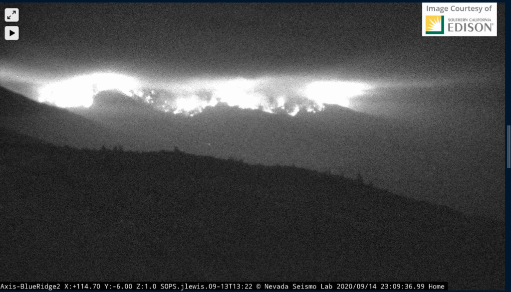
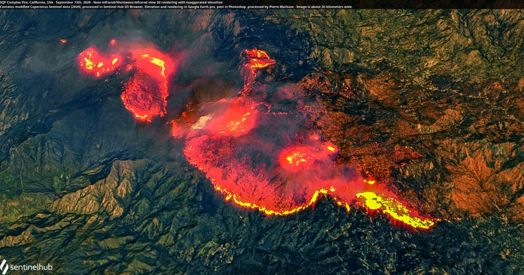
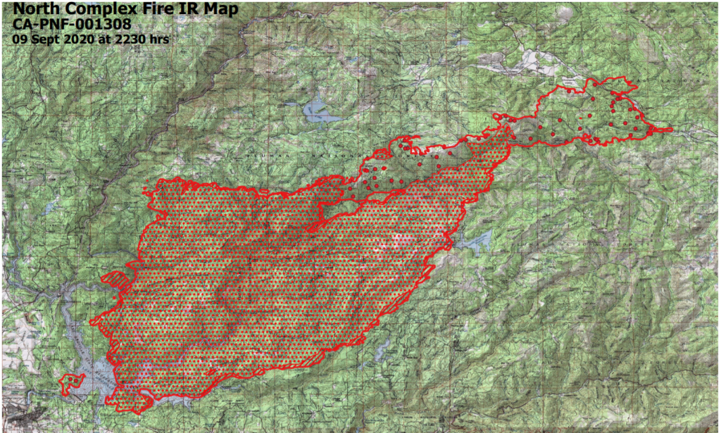
Infrared view of fire activity (from Sept 13).
September 13
10:20p: 89,000 acres, 12% contained. Lots of air action on the fire today.
Fire ran 8 miles today; crews responding by protecting newly-threatened structures. Looking to keep fire North of Highway 190 and Freeman Creek Road.
Poor RH recoveries, warm temperatures, very low minimum relative humidity, atmospheric instability and winds produced critical fire behavior primarily to the west. The fire will continue to impact the Freeman Creek Giant Sequoia Grove, structure in the Pyles Boys Camp area, communities of Sequoia Crest, Alpine Village, Camp Nelson, and Cedar Slope. It will also impact the Mountain Home State Forest, The highway 190 corridor, USFS facilities and infrastructure in the area. The fire will threaten the community of Springville, the Blue Ridge National Wildlife Refuge and the CALFire repeater site in the area. Sequoia/Kings Canyon National Park, as well as structures scattered along the west slopes.
The East Flank of the fire will continue to threaten the Blackrock Ranger Station and other USFS facilities, as well as the cultural values and resources in the Monache Meadows area.
The north flank could impact the Kern River Ranger District, Quinn Patrol adjacent private land and the Sequoia / Kings Canyon National Park.
Made it to Alpine Dr off Redwood on the way to Sequoia Crest. Fire impacted Nelson Creek drainage hard and multiple structures lost in area. But some still miraculously untouched. Crews working now to save homes and knock down hot spots. #castlefire#SQFcomplexpic.twitter.com/gOmphjoNOF
Made it part way up to sequoia crest. Structure group was scouting it. Not safe to pass further still due to tree fall and power lines. Trying to get units in tomorrow for structure defense. #castlefire#SQFcomplex. pic.twitter.com/tFL7b32aFO
Thanks for reading! If you’re interested in supporting the work that goes into providing these updates, please visit https://www.buymeacoffee.com/rs44.I really appreciate your generosity.
2:15p: Three VLATs currently assigned to and working on the fire.
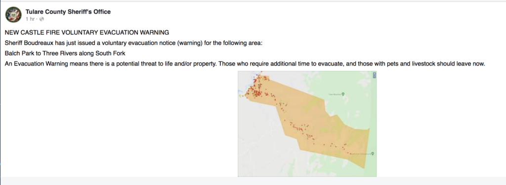
New voluntary evacuation warnings in Tulare County.
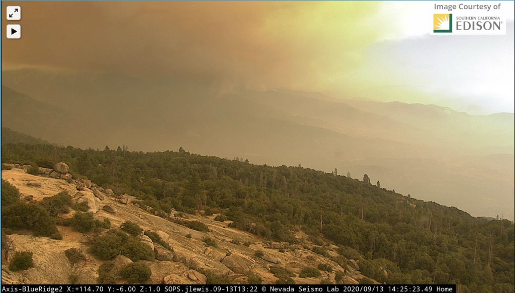
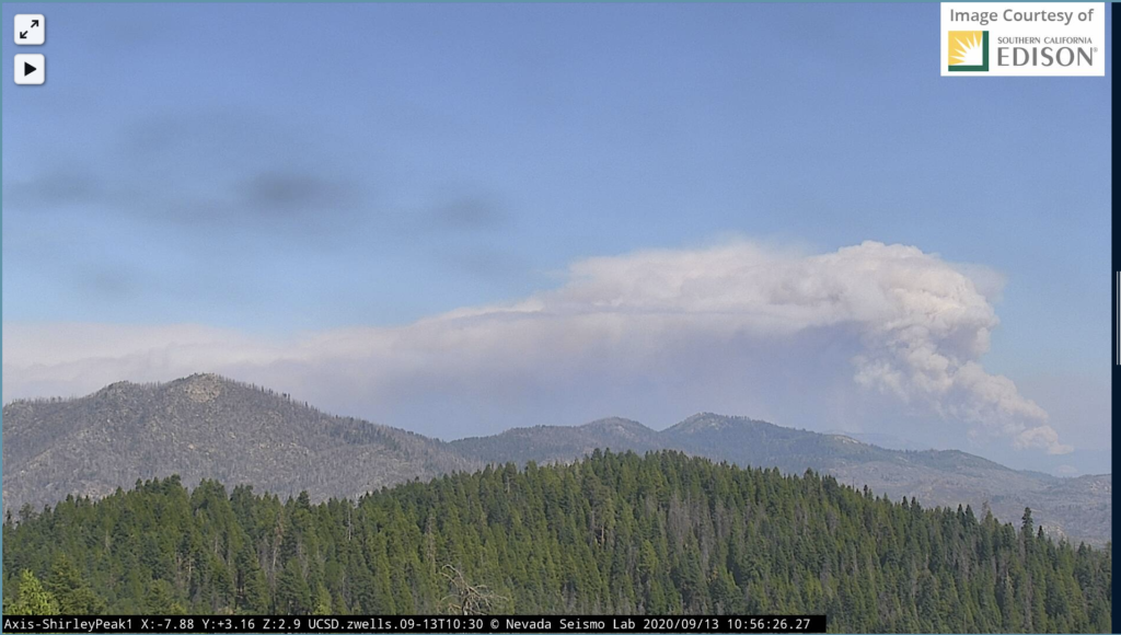
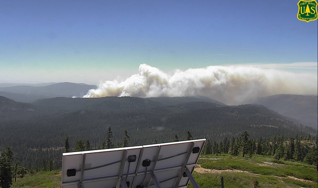
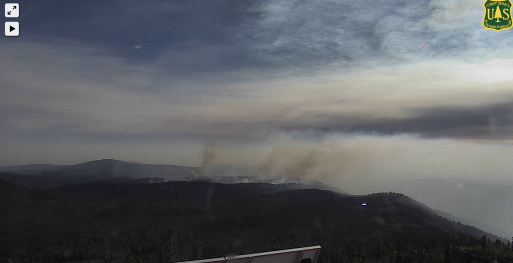
Tons of smoke coming off the fire.
12:45p: Fire looks like it’s making its way to the Balch Park area.
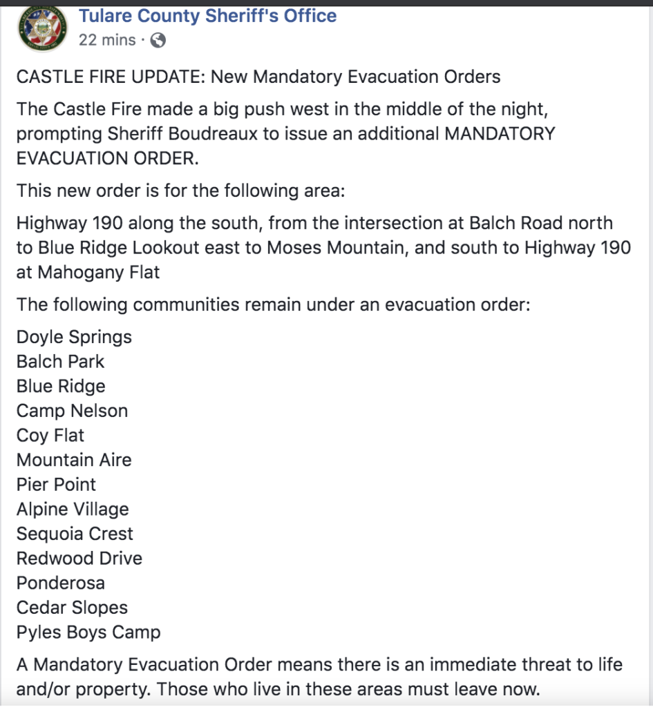
New mandatory evacuation orders in Tulare County.
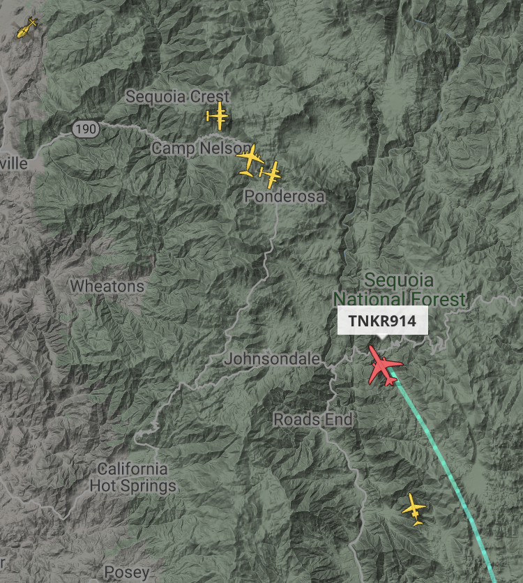
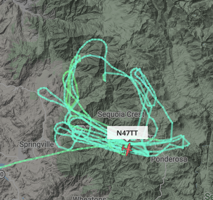
Lots of air activity. 737 passed through earlier; DC-10 and MD-87 there currently.
11:00a: Fire is making an aggressive run to the west, throwing lots of smoke early in the morning. New evacuation orders posted – do not wait to leave, this fire is moving quickly. Tankers working on that western front.
Bear Fire/Claremont Fire/North Complex Fire Updates
September 23
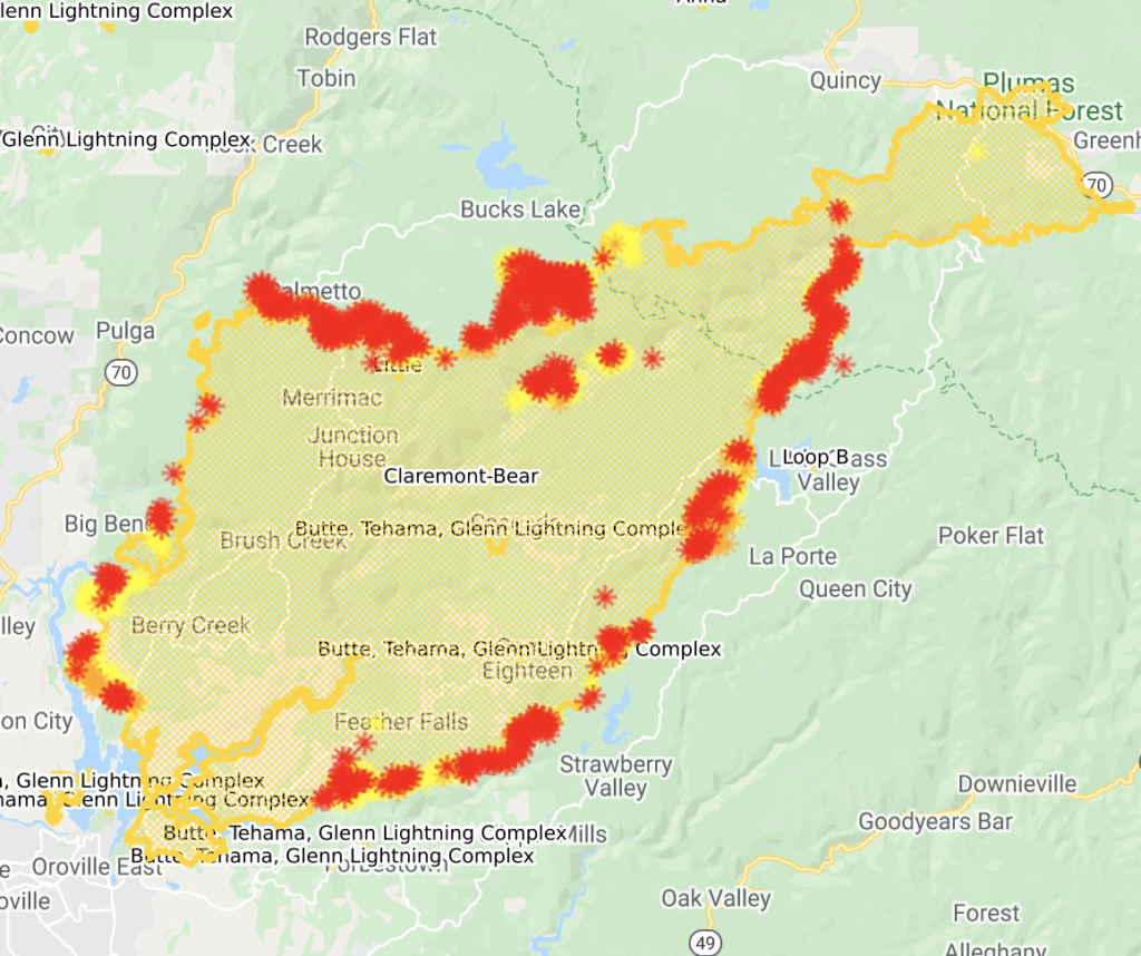
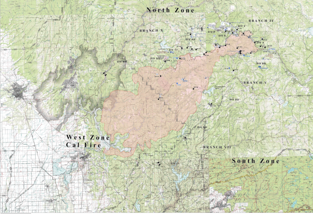
Complex is 301,000 acres and 75% contained. West Zone (the Bear Fire) is 82,500 acres and 63% contained.
South Zone: Overnight firing operations were successful around Quartz Hill and Onion Valley as crews were able to reinforce containment lines. Resources today will be focusing on monitoring these areas and looking to pick up any possible spot fires. Previously established south zone containment lines remain secured.
North Zone: Firing operations in the vicinity of Grizzly Big Creek to Grizzly Forebay were very productive last night. Crews completed firing to just south of Grizzly Forebay, where crews will look to complete firing during today’s shift. All slop over fires and spots have been picked up and will continue to be patrolled.
West Zone: Near seasonal temperatures remain, along with relative humidity values recovering to around 40 to 50% at night, and falling to around 25 to 35 % during the day. Smoke will continue to be a concern for weather, and air operations. Upslope and then upvalley winds will continue to be the theme during the day, with downslope and then downvalley winds at night. The winds are causing erratic fire behavior in the area of the South Fork of the Feather River drainage where most of the fire activity is taking place in the West Zone. The critically dry fuel moistures make the vegetation extremely receptive to fire. Change is expected to come this weekend and early next week which is expected to be hotter and drier with strengthening winds. A fire weather watch will be issued this Saturday lasting into early next week.
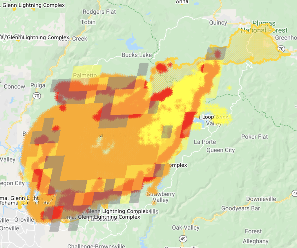
The fire continues to push to the west along the South Fork of the Feather River and has burned to and around the Ponderosa Reservoir. Check lines and tactical firing are taking place to slow the spread of the fire as firefighters aggressively construct more direct and indirect control lines to keep the fire from moving into the communities of Forbestown, Woodleaf, Clipper Mills and Strawberry Valley. In other areas of the fire crews are reinforcing direct firelines, mopping up, and conducting tactical fire patrols.
September 17
10:25a: Entire complex 281,000 acres and 36% contained; west zone is 78,000 acres and 35% contained. Total fatalities still 15 with 1 person missing.
South Zone: Due to increased humidity and lower temperatures, firefighters continued to make good progress gaining containment from Sly Creek Reservoir to Little Grass Valley. The fire remained active in the steep and rugged terrain of Onion Valley. Crews will also continue to construct indirect hand line along Fingerboard Ridge, a north/south ridgeline west of LaPorte Road. Containment lines along the northeast portion of the fire continue to hold.
North Zone: Priorities last night focused on containing spot fires, the largest of which is now approximately 200 acres on the northwest side of Red Mountain. Firefighters made good progress, and this area will continue to be the priority for resources today. Crews are working hard to contain the spots using existing roads, while also preparing indirect containment lines west to Oro-Quincy Highway
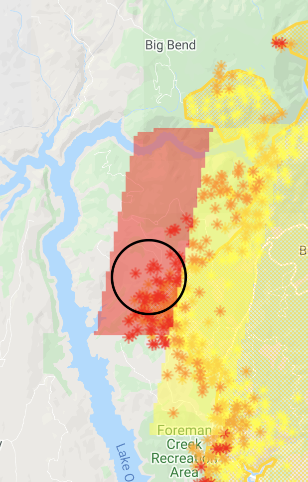
In the western portion of the fire, crews held the fire within containment lines and plan to continue preparing Oro-Quincy Highway from the Four Trees area to Big Bend, working west to the Camp Fire burn scar.
West Zone: Today there will be a cold front moving across the region making the airmass unstable and bringing stronger wind gusts. Strongest winds will be above 5,000 ft where gusts to 35 mph may occur. Lower elevations will see afternoon wind gusts up to 20 mph. Because of this there is a potential of erractic fire behavior on some parts of the fire.
Firefighters continue to fight to get into those areas of difficult access to make sure those areas of the fire are contained. The fire is burning in areas of heavy fuel loading, steep-rugged terrain intermixed with structures. Firefighters have been engaged in structure defense and constructing direct and indirect fire lines. View dozers at work here. Limited visibility due to smoke conditions has limited the use of fixed wing and helicopters to support ground personnel. The fire is actively burning in the South Fork of the Feather River with no known fire history over the past 100 years.
The utility companies have started working on the damaged infrastructure where safe to do so in the fire area. More work will continue as other areas of the fire are deemed safe.
September 14
10:50p: One additional set of human remains discovered. Total fatatlities is now 15. Two people still missing.
Complex is 265,000 acres (+4,000) and 39% (+9pp) contained. West Zone, formerly the Bear Fire, is 77,000 acres (+3,000) and 20% contained (+2pp).
From the evening briefing.
North Zone: Red Flag conditions tested containment lines today, however they held within the current perimeter. Resources in the most active areas of the fire made great progress today building containment lines from Lookout Rock down to Big Bend.
Despite red flag conditions, favorable winds allowed for a small firing operation earlier today at Four Trees to ensure the fire’s edge was kept in check, guiding it up to Oroville Quincy Highway. One 40-acre spot fire was caught on the north side of the highway by Frog Rock, but firefighters are confident they will contain it tonight.
Structure protection groups are in place surrounding the fire’s perimeter to protect nearby communities.
South Zone: Containment lines remained secure today while crews engaged in significant mop up work along Mooreville Ridge from Sly Creek Reservoir to Little Grass Valley.
With favorable winds and slightly clearer air conditions, two small strategic firing operations were executed along the north side of the Pacific Crest Trail (PCT) to Onion Valley, and in the extremely steep terrain of McCarthy’s Bar. During that small window of time when clearer skies allowed for aircraft to fly, two type 1 helicopters made water drops to support firefighters in these areas. Tonight if conditions allow, crews will continue firing along the PCT east to Chimney Rock, which will eventually tie into a small section of LaPorte Road (several miles north of the town of La Porte).
West Zone: The predicted gusty southwest winds and low humidity with periods of near critical fire weather conditions did not materialize as predicted today nor will it over the next two days. There will be an increase in temperatures but the humidity will stay relatively high. The smoke layer over the fire has started to disperse due to the slight increase in winds over the fire. Because of this, aircraft will have the visibility to be able to fly over the fire but the clearing of the smoke will have a negative effect on the fire causing the fire activity to increase.
Firefighters have been successful in strengthening several existing containment lines, developing new containment lines and extinguishing several interior hot spots in an attempt to prevent further spread. Firefighters continue to fight to get into those areas of difficult access to make sure those areas of the fire are contained. Several contingency fire lines are being developed as well.
Thanks for reading! If you want to support the work that goes into providing these updates, you can do so here: https://www.buymeacoffee.com/rs44. Thank you so much for your generosity.
North Zone: Firefighters were able to conduct night firing operations near Four Trees, and will continue to prep contingency lines off of roads in the area and on Red Mountain. Priority for firefighting resources remains the areas south of Bucks Lake where firefighters will work to secure all the progress made by night firing operations. Structure protection groups are in place surrounding the fire’s perimeter to protect nearby communities.
South Zone: Containment lines remained secure, while some interior islands of fuel burned in the steep terrain of the McCarthy’s Bar area. Firefighters were successful in working the fire’s edge along Mooreville Ridge to Sly Creek Reservoir.
West Zone: Firefighters have been successful in strengthening several existing containment lines, developing new containment lines and extinguishing several interior hot spots to prevent further spread. They will continue to fight to get into those areas of difficult access to make sure those areas of the fire are contained. Several contingency fire lines are being developed as well.
Last night, firefighters continued to prepare areas of the fire that will be impacted by the predicted Red Flag Warning with south west winds coming in on Monday, late morning, over the fire area.
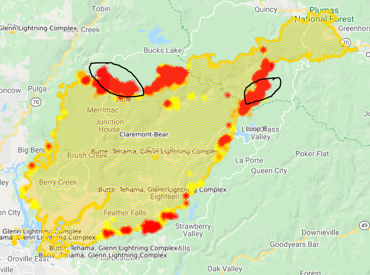
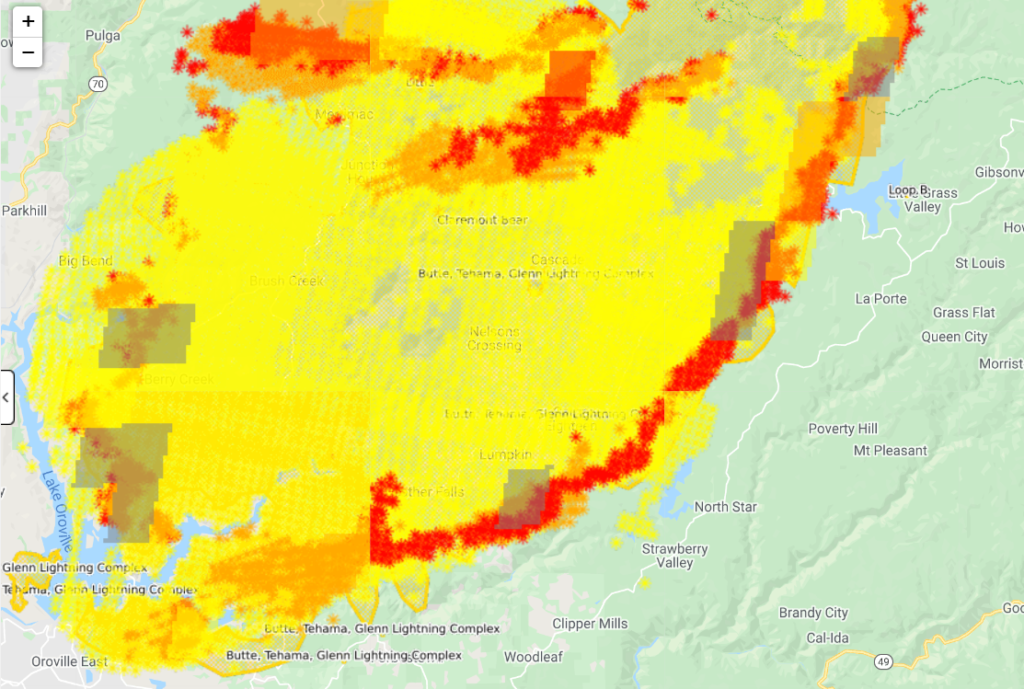
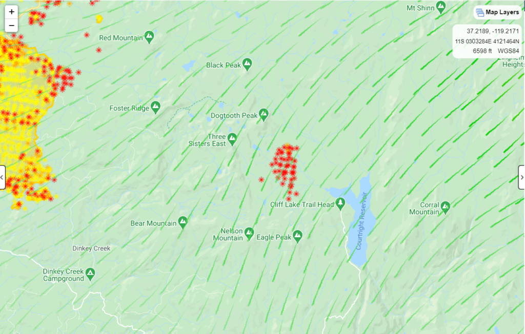
Recent hot spots, from satellites, circled.
Thanks for reading! If you want to support the work that goes into providing these updates, you can do so here: https://www.buymeacoffee.com/rs44. Thank you so much for your generosity.
September 13
10:10p: Two additional bodies have been uncovered, bring the total death toll to 14.
261,000 acres, 26% contained. The West Zone (formerly the Bear Fire) is 74,000 acres and 18% contained.
Red Flag Warning tomorrow with southwest breezes transition to downslope and down canyon winds with gusts up to 35mph. Minimum humidity near 15%.
North Zone: Mop up continues around the northeastern perimeter of the fire, and lines continue to hold well. Thanks to cooperative winds, firefighters were able to continue protecting the Lookout Rock and Ontop Mine areas. Moving west, fire activity is more active and in rugged terrain. Crews were able to engage directly with the fire’s edge and mop up other areas, working toward their goal of tying into the 2018 Camp Fire scar.
Some spotting behavior did occur, however firefighters were quick to catch them. Night crews plan to revisit areas that were already fired to make sure they are complete and secure. Structure protection groups are in place surrounding the fire’s perimeter to protect nearby communities, taking extra care in getting through the incoming wind event.
South Zone: Firefighters made great progress today in improving and securing containment lines, and were successful in making the final connection between Little Grass Valley Reservoir south along Mooreville Ridge to Sly Creek Reservoir. In the extremely steep terrain near McCarthy’s Bar, crews were able to start firing operations which will eventually back into the main body of the fire.
West Zone: On the afternoon of September 8th, 2020 the North Complex fire entered Butte County with a vengeance, driven by extreme winds, heavy dry fuels, and steep terrain. The fire remains very active and now more than ever we need to remain vigilant.
Throughout the day, despite the lack of visibility, the weather continued be favorable with minimal winds, lower temperatures, and higher humidities, which enabled the firefighters on the line to accomplish several tasks and develop further containment lines.
Firefighters have been successful in strengthening several existing containment lines, developing new containment lines and extinguishing several interior hot spots to prevent further spread. They will continue to fight to get into those areas of difficult access to make sure that those areas of the fire are contained. Several contingency fire lines are being developed as well.
Due to the size, location, difficult access of this fire and predicted weather, the firefighters have a significant amount of work still to complete. Firefighters are prepping areas of the fire that will be impacted by the predicted Red Flag Warning with south west winds coming in on Monday, late morning, over the fire area. CAL FIRE Damage Assessment Teams continue the documentation of destroyed and damaged structures within the fire area.
10:15a: Operations update
North Zone: Fire activity was calm last night with humidity increasing and smoke laying over the area. Firefighters will continue firing operations today while conditions allow in the Lookout Rock and Ontop Mine areas. Crews will continue to secure what was already fired, with the goal of meeting indirect bulldozer lines where the 2018 Camp Fire scar is located. Structure protection groups are in place surrounding the fire’s perimeter to protect nearby communities, taking extra care in getting through the next incoming wind event.
South Zone: Fire activity was also calm last night in the south zone as firefighters worked to improve containment lines. Near McCarthy’s Bar, crews will continue scouting for the best opportunities to bring fire between ridgelines and current containment lines. Crews will continue constructing hand line from the west shore of Little Grass Valley Reservoir, moving south along Mooreville Ridge and Sly Creek Reservoir.
West Zone: Overnight the weather was in the firefighters favor with decreased winds, lower temperatures, and higher humidities, allowing crews to continue to aggressively fight fire and develop further containment lines.
Firefighters have been successful in strengthening several existing containment lines, developing new containment lines and extinguishing several interior hot spots to prevent further spread. They will continue to fight to get into those areas of difficult access to make sure that those areas of the fire will be contained. Several contingency fire lines are being developed as well.
Due to the size, location, difficult access of this fire and predicted weather, the firefighters have a significant amount of work to still complete. Firefighters are prepping areas of the fire that will be impacted by the predicted south west winds coming in on Sunday and Monday over the fire area.
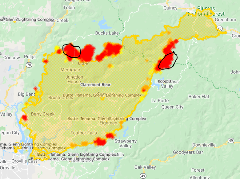
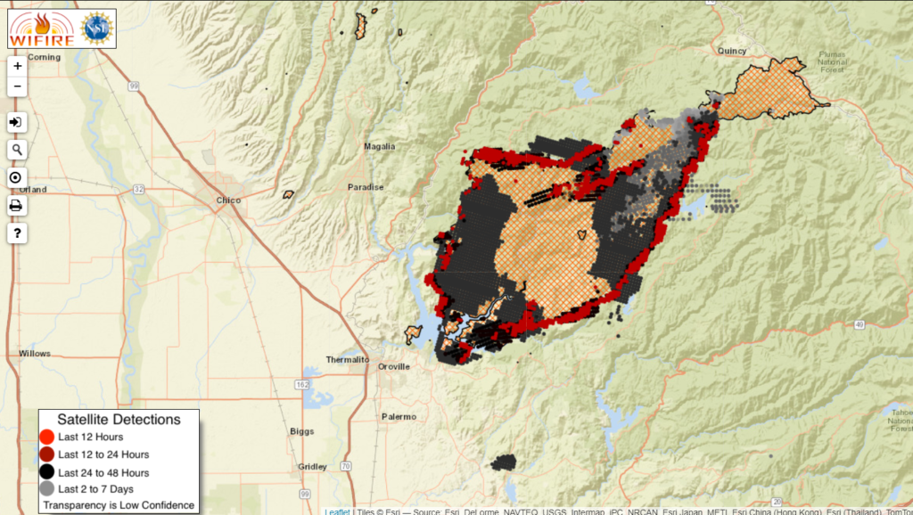
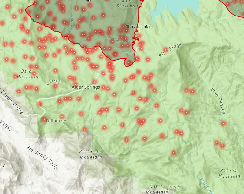
Updated map. Most of the red has burned hot in the last 12-18 hours.
Thanks for reading! If you want to support the work that goes into providing these updates, you can do so here: https://www.buymeacoffee.com/rs44. Thank you so much for your generosity.
September 12
10:45p: 258,000 acres, 22% contained. West zone is 73,000 acres, 10% contained.
Tragically, 12 people have died in the fire and an additional 13 are missing.
North Zone: Firefighters continued gaining depth mopping up along the north and northeastern flank. Moving west, firing operations conducted today in the Lookout Rock and Ontop Mine areas will continue progressing tonight using indirect bulldozer lines to meet with the 2018 Camp Fire scar. Structure protection groups are in place surrounding the fire’s perimeter to protect nearby communities.
South Zone: Firefighters will work tonight to improve containment lines built today. Near McCarthy’s Bar, crews will continue scouting for the best opportunities to bring fire between ridgelines and current containment lines. Moving south, firefighters were successful in engaging directly with the fire’s edge. Tomorrow, they plan to continue constructing hand line around the west shore of Little Grass Valley Reservoir south along Mooreville Ridge and Sly Creek Reservoir.
Thanks for reading! If you want to support the work that goes into providing these updates, you can do so here: https://www.buymeacoffee.com/rs44. Thank you so much for your generosity.
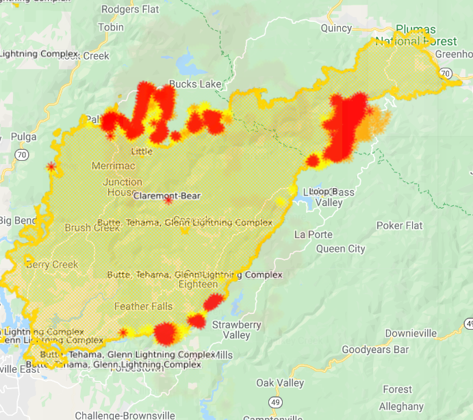
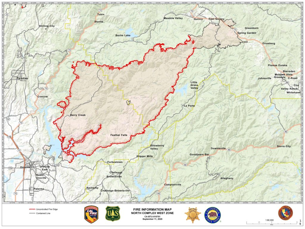
11:15a: CalFire released a structure damage map, screenshot below. Fire is 252,000 acres and 21% contained. The North Complex West Zone (formerly the Bear Fire) is 72,000 acres and 7% contained.
North Zone: Firefighters continued to make good progress on securing containment lines and there was no significant fire growth. Firing operations will be focused around the Lookout Rock and Ontop Mine areas. Structure protection groups continue to work in communities surrounding the fire’s perimeter.
South Zone: The most activity was located on the western side of Little Grass Valley, where firefighters continue to scout for opportunities to establish direct and indirect line construction.
Heavy smoke still blanketing the area.
Thanks for reading! If you want to support the work that goes into providing these updates, you can do so here: https://www.buymeacoffee.com/rs44. Thank you so much for your generosity.
September 111
11:55p: In slight good news, the number of fatalities has been reduced from 10 to 9: One of the bodies found was actually from an anatomical skeleton model.
Heavy smoke moderated fire activity throughout the day, helping firefighters.
In the north zone, firefighters continued working on a buffer zone to protect Bucks Lake, Haskins, and Highlands. The fire is currently 5 miles from the Meadow Valley and Tollgate areas.
In the south zone, the fire burned close to the west shore of the Little Grass Valley Reservoir. It’s still distant from structures. Community of La Porte is protected by fire lines and hose lays. 500 additional firefighters moving to a camp in Brownsville.
Updated fire map. Most activity on the periphery, but no substantial acreage growth as of this evening.
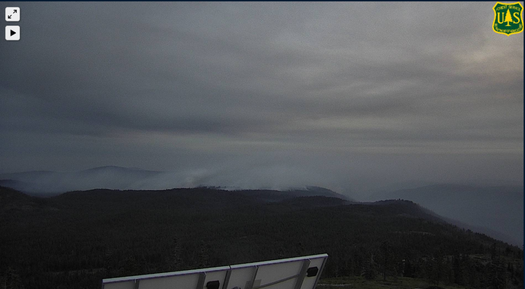
Here’s the fire from the Bunker Hill camera.
Thanks for reading! If you want to support the work that goes into providing these updates, you can do so here: https://www.buymeacoffee.com/rs44. Thank you so much for your generosity.
11:15a: Fire now 252,000 acres, 23% contained (the west zone, formerly the Bear Fire, is 70,000 acres and 5% contained).
North Zone: Last night, crews detected and successfully responded to spot fires on the fire’s north edge. Today, crews will continue constructing lines to connect to Highway 70 in an area north of Elephant Butte and reinforce structure protection in communities.
Buck’s Lake, Haskins, Highlands, and Meadow Valley all currently safe (“no threat right now”) as firefighters “finished off” the fire in that area. Resources still there just in case the southwest winds push the fire in that direction. Mandatory evacuations there still in place.
Resources working Red Mountain to Oak Ridge. Past there, using road systems and contingency lines from the Camp Fire for containment lines.
South Zone: Crews have constructed hand and dozer lines with hose lays, utilizing existing roads to complete protection around the town of La Porte. Today, crews will continue to establish direct and indirect line and provide structure protection in the La Porte (dozer lines) and Little Grass Valley Reservoir areas. They’re hoping to build breaks west of La Porte Road, using it as a backup. Not too much activity in the fire there last night. Some activity around Little Grass Valley Reservoir, though infrastructure still stands.
“No issues” around Claremont Peak.
Threatened last night, the infrastructure at Bloomer Hill stands!
Thanks for reading! If you want to support the work that goes into providing these updates, you can do so here: https://www.buymeacoffee.com/rs44. Thank you so much for your generosity.
September 10
10:25p: From the official release, here’s where the battle stands.
North Zone: The fire remains in the current footprint from Lee Summit to Claremont Peak. Crews engaged with tactical firing operations near Lookout Rock; reinforcing structure protection in the Bucks Lake, Haskins, and Highlands areas.
They are prepping existing roads and building dozer lines to tie in with old fire scars and contingency lines from the Camp Fire. This will eventually tie in with Highway 70 north of Elephant Butte.
South Zone: Tonight, crews will continue to construct line along the Pacific Crest Trail and prep a series of existing roads south of Little Grass Reservoir to tie into La Porte Road.
Structures within the Little Grass Valley Reservoir area are not currently impacted or threatened by fire but are being prepped with structure protection and hose lays as a contingency.
Thanks for reading! If you want to support the work that goes into providing these updates, you can do so here: https://www.buymeacoffee.com/rs44. Thank you so much for your generosity.
10:15p: Seven additional fatalities confirmed, bringing total number to 10. Sadly, the missing 16 year old has been identified as one of them. 16 people missing (up from 12 yesterday).
2,000 structures destroyed, 23,000 more threatened.
9:55p: Firefighters actively defending structures off Springton Road by Maidu Run. Trying to stop eastern spread with dozer line between Maidu Run and Lothrop Lane.
The fire has also made its way to Bloomer Hill, as captured dramatically by ALERT cams. Important infrastructure here, so firefighters will be working to defend as best they can without reinforcements coming due to road blockage.
Thanks for reading! If you want to support the work that goes into providing these updates, you can do so here: https://www.buymeacoffee.com/rs44. Thank you so much for your generosity.
3:50p: Fire still burning off Shady Lane in the west Berry Creek area. A lone civilian fought flames there as his neighbor’s house burned. Crews activiely defending structures there and on Kelly Ridge. More information coming at 6:01p with the nightly press conference. No planes currently in the area.
1:40p: Tons of smoke in the area, limiting air activity. Satellite isn’t picking up new heat detections in the last 12 hours, a testament to cooling temperatures, decreased wind, and slightly higher humidity. Far from out of the woods, though.
10:30a: Acreage revised down to 247,000; structure damage up to 2,000 (there’s been confusion over whether this number is 200 or 2,000). Winds died down Wednesday night after their gusts drove fire growth on Tuesday. Temperatures have also fallen and humidity has increased.
Firefighters spent Tuesday/Wednesday performing rescue missions. Now they’re focusing on containment lines to protection threatened population centers. They will also begin damage inspection.
Visibility remains low because of the smoke sitting in the area.
Paradise lifting its evacuation warning for Zone 14, good news for an area that can’t catch a break.
The Bear Fire will now be known as the North Complex West Zone.
Thanks for reading! Hoping to provide useful information about the Bear Fire/North Complex Fire. Would appreciate any coffee to listen to the scanner later into the night 🙂 https://www.buymeacoffee.com/rs44
9:15a: Still 12 people missing. Of the three fatalities, one was found in a car, trying to flee the flames.
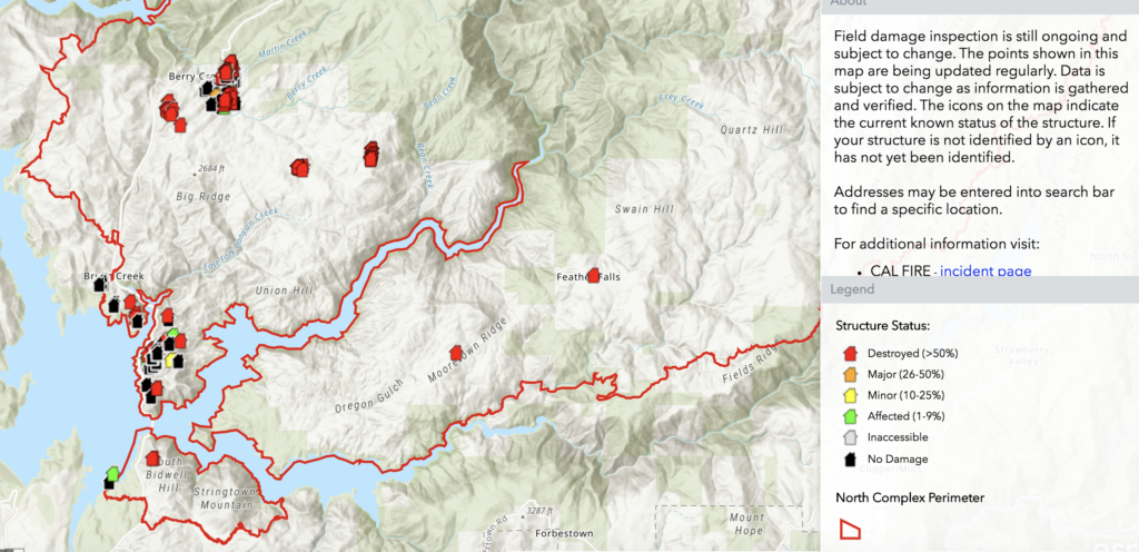
The mountain community of Berry Creek has been nearly destroyed by flames. Camp Okizu, a retreat for children suffering from cancer, has significant damage.
Official incident map below.
7:30a: 26,000 buildings at risk, at least 200 have been destroyed (on initial count). 1,300 firefighters battling the blaze.
Fire burning hottest at south and southeast (per GOES-17). Winds will shift to come from the south/southwest, which could threaten smaller communities currently to the fire’s east. Potential for extreme fire behavior where wind meets slope.
Thanks for reading! Hoping to provide useful information about the Bear Fire/North Complex Fire. Would appreciate any coffee to listen to the scanner later into the night 🙂 https://www.buymeacoffee.com/rs44
September 9
10:15p: 252,000 acres, making the North Complex Fire the ninth largest in state history. Most of that happened in a a single day when the fire jumped containment lines and ran to Lake Oroville. You can see that charge here.
Thanks for reading! Hoping to provide useful information about the Bear Fire/North Complex Fire. Would appreciate any coffee to listen to the scanner later into the night 🙂 https://www.buymeacoffee.com/rs44
The ops map for the fire (full resolution available here).
6:45p: Sad news from the press conference: Three confirmed fatalities in Butte County. 100 people have been rescued, the sheriff’s office is still looking for 12 more, and a preliminary count shows 200 structures damaged or destroyed.
Fire still east of Kelly Ridge. The winds yesterday – 45 mph – led the fire to jump its containment lines and make a 200-210,000 acre run. In a single day, the fire burned enough acres to be one of the largest 8 fires in California history.
2:10p: Six firefighters were sheltering off Lumpkin Road due to fire activity. They have since been rescued, one with a respiratory injury.
Satellite detection shows the fire almost surrounding Lake Oroville. Winds blowing south around 10mph.
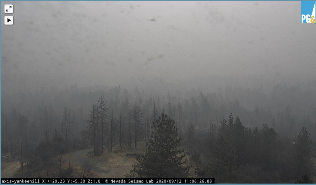
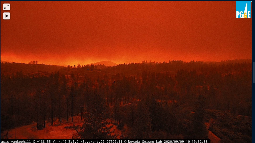
Here’s the fire from Yankee Hill. This image is from right now.
Bidwell Bar Bridge surrounded by flames.
The Bidwell Bar Bridge is surrounded by fire in Lake Oroville during the Bear fire in Oroville, California, as dangerous wildfires rage across the state. https://t.co/M4BOsrBqY9pic.twitter.com/fxkevRHuMb
A few burned out properties at #Creekfire yesterday morning, then extreme fire activity all night/this morn at the #Bearfire near #Oroville. Shot through the night. Extremely tired. It's still burning. Fire crews spread extremely thin.
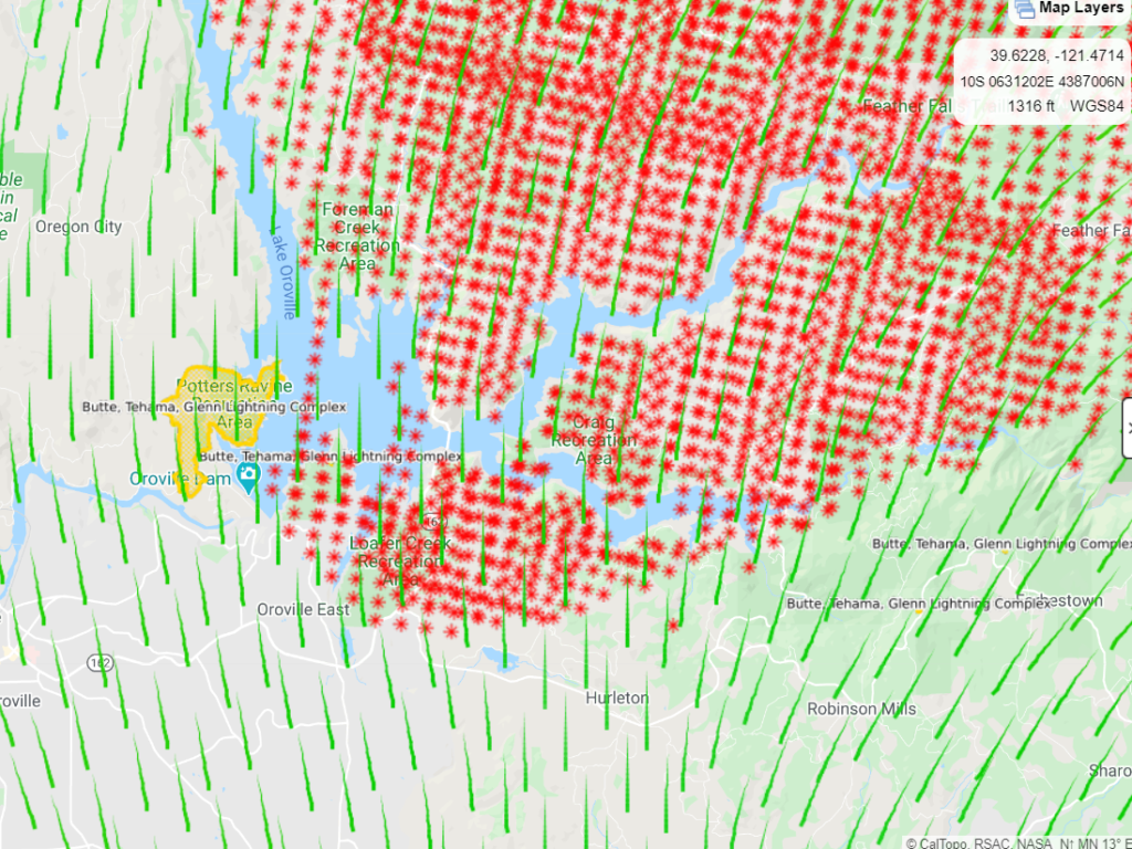
8:30a: Satellite heat detections show the North Complex Fire show the fire grew by around 250,000 acres in 24 hours, pushing hard to the south. This would make it the 7th or 8th largest fire in CA history, a standing achieved in just 24 hours. Those same maps show the fire threatening the town of Oroville and the Highway 70 corridor.
To put last night's incredible southwestward run on #BearFire into perspective: a conservative estimate based on current satellite heat detections suggests fire expanded by ~250,000 acres in ~24 hours. Fire now directly threatening Oroville, Hwy 70 corridor. #CAwx#CAfirepic.twitter.com/4J6epC1FyR
You can see the fire in the distance with the Camp Fire scar in the foreground. Paradise is close to the fire, but its movement to the south puts a little less pressure on the recovering town.
10:30p: Lives at risk. This is currently the fire to watch. Follow local sheriffs, listen to evacuation order, be prepared to leave on a minute’s noticed when warned.
#BearFire/#NorthComplex – Extreme fire activity around the Bean Creek Rd area where reported civilians are trapped, resources will attempt to get when possible. Life safety/evacuations is the only priority right now.
10:10p: Resources are stressed thin. If you’re in an evacuation zone, get out immediately – there might not be anyone to rescue you if things go south.
Fire jumped the Feather River, trapping 8-9 civilians.
#BearFire/#NorthComplex – Reports of 8-9 civilians trapped in the 1900 block of Bean Creek Rd which is off Bald Rock Rd where fire has jumped the Feather River. More resources being sent up into the Berry Creek area.
Paradise, decimated by the Camp Fire in 2018, is just north of the evacuation zones and not currently in the direction of the fire. It could be at risk, though, with slight wind changes and further westward spread.
There has been some undergrowth since the Camp Fire and imperfect cleanup, meaning fuels are there.
Yes, work in that area often, there is a lot of under growth with not much clean up as some properties have been abandoned, along with numerous burnt trees from Camp Fire yet to be cut down & removed, also many locations with fallen & cut up trees left stacked.
9:00p: Fire has reached the east side of Lake Oroville, burning at Lumpkin Bridge.
8:50p: Forbestown will be threatened in the next couple of hours as the fire continues to spot some 2 miles in front of itself. The fire has run 25 miles today and may be approaching the east side of Lake Oroville. Continuing with a critical rate of spread.
40,000 acres have burned as the fire exhibits extreme behavior with a growing pyrocumulus plume reaching 40,000 feet.
Spot fires running ahead of the complex and rushing toward the community of Cascade. Heed all evacuation orders. Be ready to move, orders are coming fast.
#BearFire/#NorthComplex – There are spot fires 2-4 miles out in front of the fire right now & it's getting close to the community of Cascade. Some people refusing evacuation orders in the Clipper Mills area.. please evacuate if ordered. pic.twitter.com/oJnDUjoBF3
The North Complex Fire has jumped containment lines established a few weeks ago when a lightning storm started the Claremont Fire. Driven by the offshore winds – some gusting to 60+ mph – the fire is racing southwest.
Daniel Swain, UCLA climatologist, likens it to the Camp Fire based on shape, smoke cloud, and vegetation ahead. The danger goes without saying. Be prepared to evacuate, listen to orders, and get out if you see flames because the fire is moving fast.
Yes…bad feeling about this one; the only mitigating factor is that there aren't any big towns immediately downwind. But under current conditions, this thing could run to the Sac Valley eastern margin…
Also risk of a plume collapse, which could accelerate the fire’s spread and cover a vast area in smoke.
#BearFire/#NorthComplex – FF's in the La Porte area being warned about potential for the smoke column to collapse. Fire is down as far as Lumpkin Ridge but not yet @ La Porte per radio traffic.
Expected increased wind speed will lead to increased spread through uphill runs towards Hell Hole Dam.
Monday night: Downslope flows will develop, and ridgetop east to southeast winds will lead to poor relative humidity recovery and warm temperatures.
Tuesday: Warm and dry conditions persist, with afternoon temperatures around 80 and relative humidity in the mid teens. Gusty afternoon southwest winds will develop on ridgetops and aligned drainages.
Thanks for reading! If you want to support the work that goes into providing these updates, you can do so here: https://www.buymeacoffee.com/rs44. Thank you so much for your generosity.
10:00a: Crews have made progress making containment lines on the eastern side to secure the Airport Flat area. Some pockets of heat within the containment line; these, and standing dead fuel, pose safety risk to firefighters.
Contingency lines – in case fire activity picks up dramatically – created around Little Dear Creek to the fire’s north. On the southwest, teams began clearing hazardous trees to allow for safer access to the fire. Line now extends 0.5 miles down the ridge near the South Creek and South Fork of the Rubicon.
Critical fire conditions coming this afternoon.
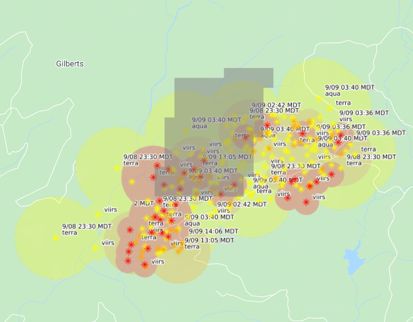
Satellites haven’t picked up any hot spots in 24 hours.
Thanks for reading! If you want to support the work that goes into providing these updates, you can do so here: https://www.buymeacoffee.com/rs44. Thank you so much for your generosity.
September 13
10:00p: Little is burning hot. Fire has checked itself on reaching the King Fire scar. Some backing on the southwest ridge.
However, critical fire conditions return Monday. Winds will increase uphill runs to Hell Hole Dam. From the incident page:
Warm and dry conditions with poor overnight humidity recovery will continue over the next several days. Low pressure drifts toward the coast, gusty southwest winds will develop Monday afternoon, with near critical fire weather conditions occurring across ridgetops and aligned drainage.
Sunday night: Downslope flows will develop, though ridgetop east to southeast winds will lead to poor relative humidity recovery and warm temperatures.
Monday: Warm and dry conditions persist, with afternoon temperatures in the low 80’s and relative humidity in the low teens. Gusty afternoon southwest winds will produce near critical fire weather conditions on ridgetops and aligned drainages.
Firefighters working to establish direct control lines where possible, using indirect control line where direct control lines aren’t feasible. They’re holding and monitoring existing lines along current perimeter and providing structure defense to residential structures in the threatened communities.
Thanks for reading! If you want to support the work that goes into providing these updates, you can do so here: https://www.buymeacoffee.com/rs44. Thank you so much for your generosity.
10:00a: Critical fire conditions coming today. With clearing smoke, firefighters hope for tanker passes on hot spots on the fire’s northeastern front.
Operations update: Yesterday, crews focused on strengthening the lines east and south on the Fork Fire to prevent fire movement toward Gerle Creek and Airport Flat.
Today, firefighters will shift their work toward the north and east where winds may push fire activity and test containment lines. Crews will continue to mop up and hold the south side of the fire area.
Firefighters have identified a planned fire line near the southwest edge of the fire toward the South Fork of the Rubicon River. Crews continue to scout for safe containment options further west across the Rubicon River, although steep topography and weakened snags present many potential challenges.
On the northeast side near Little Deer Creek, a containment line was established and improved. In preparation for the critical fire conditions, the crews will attempt to use helicopters and Super Scoopers to cool active fire spots along the northeast edge, if weather permits.
Thanks for reading! If you want to support the work that goes into providing these updates, you can do so here: https://www.buymeacoffee.com/rs44. Thank you so much for your generosity.
September 12
10:30p: 1,700 acres, 7% containment. Satellites still not picking up any heat; nothing visible in tonight’s camera.
Fire is in the Rubicon drainage and King Fire scar. Sparse fuel has slowed it.
Weather: Saturday night: Downslope flows will develop, though ridgetop east to southeast winds will lead to poor relative humidity recovery and warm temperatures. Sunday: Warm and dry conditions persist, with afternoon temperatures around 80 and relative humidity in the teens. Gusty afternoon southwest winds will produce near critical fire weather conditions on ridgetops and aligned drainages.
11:00a: No change in acreage or containment (full containment expected September 22). Satellites not picking up any major heat in the last 24 hours.
Warm and dry conditions with poor humidity recovery will continue and nearby high pressure will lead to light, mainly diurnal upslope and downslope winds through Saturday night. Low pressure approaching the coast will produce increased southwest winds on Sunday and Monday, with critical fire weather conditions possible.
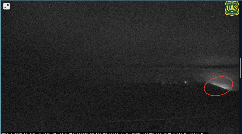
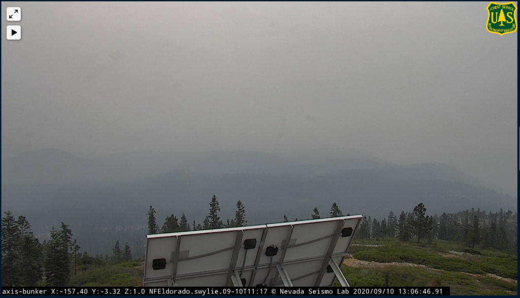
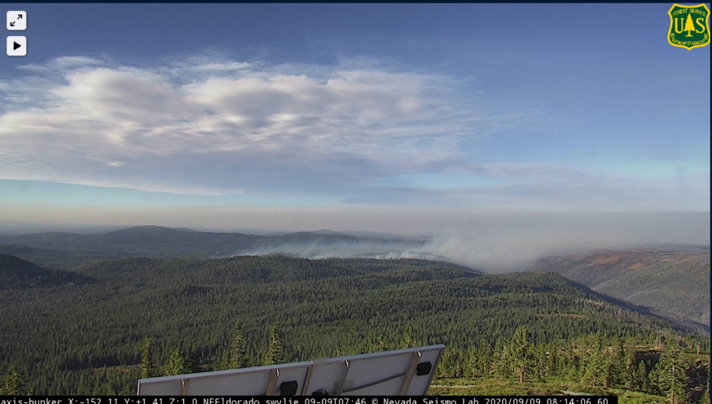
Fire was possibly visible last night on the Bunker Hill cam; this morning, no flames can be seen and little smoke. Overall conditions clearing a bit.
Thanks for reading! If you want to support the work that goes into providing these updates, you can do so here: https://www.buymeacoffee.com/rs44. Thank you so much for your generosity.
September 11
11:50p: Aerial mapping today – no air attacks because of visibility – puts the fire at 1,600 acres, versus yesterday’s estimate of 2,200. 7% containment. Smoke layer and low winds meant little fire activity (satellite doesn’t pick up new hot spots). However, the smoke will likely start to clear tomorrow afternoon and winds will pick up Sunday into Monday, potentially leading to increased fire activity.
Mandatory evacuation orders lifted – now evacuation warnings.
Thanks for reading! If you want to support the work that goes into providing these updates, you can do so here: https://www.buymeacoffee.com/rs44. Thank you so much for your generosity.
4:45p: Little heat coming from the fire. Press conference at 6p PDT, which will hopefully provide more details.
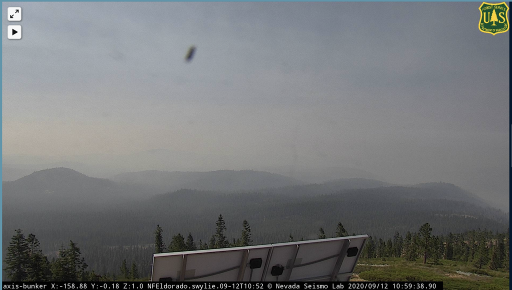
11:45a: Heat detection only picking up one new hotspot in the last day, this one on the fire’s south east end. Bunker Hill camera now oriented away from the fire, so hard to tell what smoke’s being thrown.
Another satellite image showing little activity
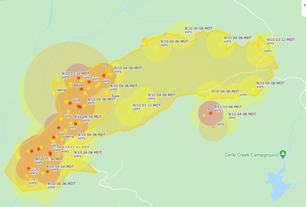
Ongoing mapping activity (fire currently estimated at 2,200 acres).
September 10
10:00p: Two minor injuries confirmed.
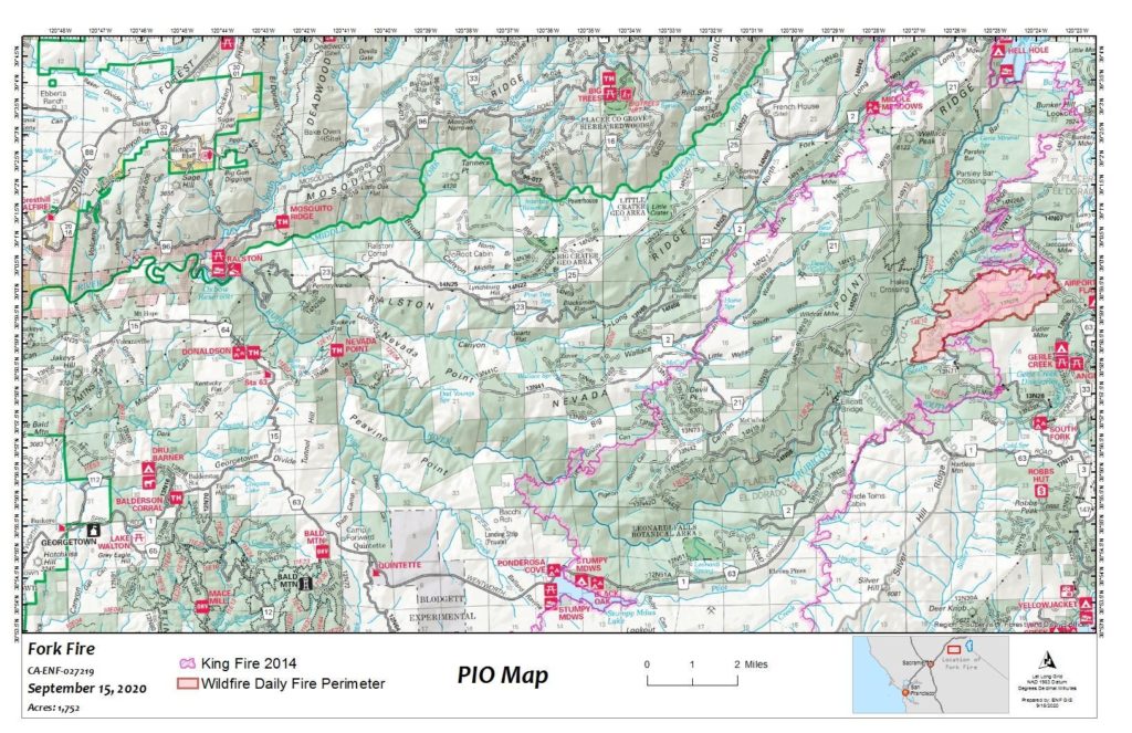
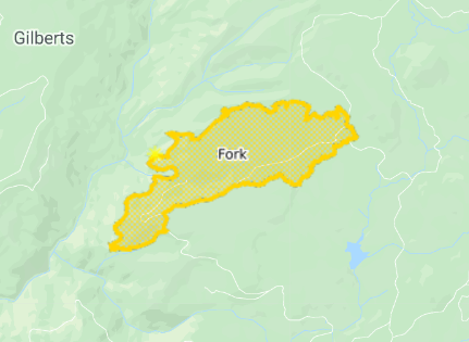
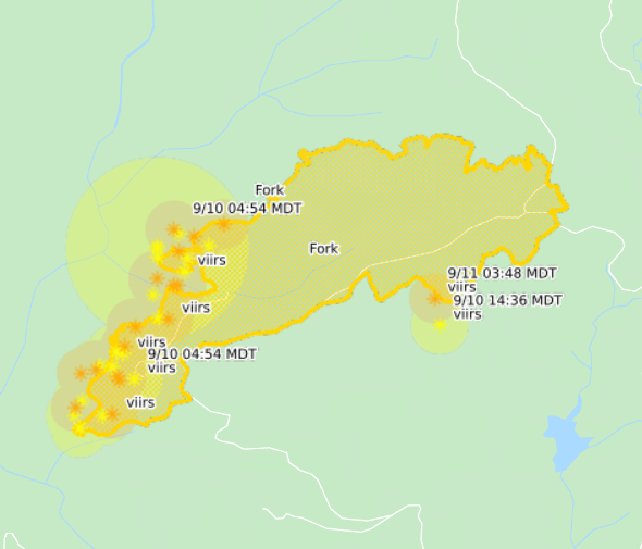
9:45p: Fork Fire size revised up to 2,200 acres (weather conditions have prevented accurate mapping; this is based on drone and on-the-ground data). It’s burning in the Rubicon River drainage and King Fire burn scar. Rugged terrain makes firefighting difficult and dense timber and fuel from trees killed in the King Fire aided initial spread.
Operational goals are to protect private property and nearby communities. Operational objectives are to keep the fire west and north of Wentworth Springs Rd., east of 11 Pines Rd. and south of Hell Hole Reservoir.
Thanks for reading! If you want to support the work that goes into providing these updates, you can do so here: https://www.buymeacoffee.com/rs44. Thank you so much for your generosity.
4:15p: Fire still burning in the Rubicon Canyon with some activity in the King Fire burn scar.
Communities of Stumpy Meadows, Quintette, and Volcanoville still under a mandatory evacuation order.
1:00p: Not much to update. No planes in area, no notable recent hotspots per heat-detecting satellites. Bunker Hill camera is back online. There doesn’t look to be much smoke rising from the burn area, but it’s also difficult to tell because of the all-around smokey conditions and the possibility that the smoke is lying low to the Rubicon River drainage area.
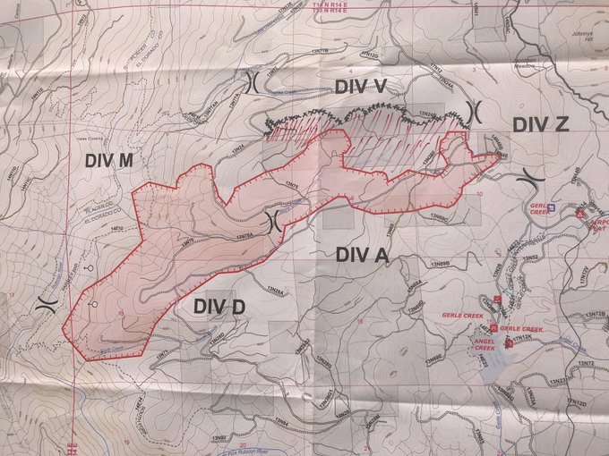
11:00a: Fire revised down to 2,000 acres. Wind has shifted to blow lightly from the west. Official map shows that wind and expected fire movement into Div V lines.
Few new hot spots detected via satellite in the last 12 hours. Unfortunately, the best camera angle of the fire is stuck on an image from the early morning.
7:20a: Yesterday, firefighters built 2.5 miles of dozer line on the South/Southeast side of the fire. That line is currently holding. Two medium super scoopers dumped from Loon Lake onto fire hot spots.
Smoke is still down from a couple days ago.
Thanks for reading! Hoping to provide useful information about the Fork Fire. Would appreciate any coffee to listen to the scanner later into the night 🙂 https://www.buymeacoffee.com/rs44
According to GOES-17 satellites, nothing in the fire is burning particularly hot, a testament to the aerial work done yesterday.
September 9
10:00p: Officially 2,500 acres, 0% containment. Winds shift in the next 12-18 hours to come from the west/southwest, though they should stay light (~10mph). There is risk that this pushes the fire out of the Rubicon drainage and King Fire scar and into areas that haven’t seen recent burns.
Thanks for reading! Hoping to provide useful information about the Fork Fire. Would appreciate any coffee to listen to the scanner later into the night 🙂 https://www.buymeacoffee.com/rs44
5:10p: Fire cams continue to show less smoke activity. Satellite maps not indicating expansion, but important to note the fire is still officially 0% contained. Three tankers working on the fire.
All 18 national forests in California are now closed because of extreme fire conditions.
2:00p: Some air activity of the fire. Smoke creeping into the Tahoe Basin, visible near Emerald Bay.
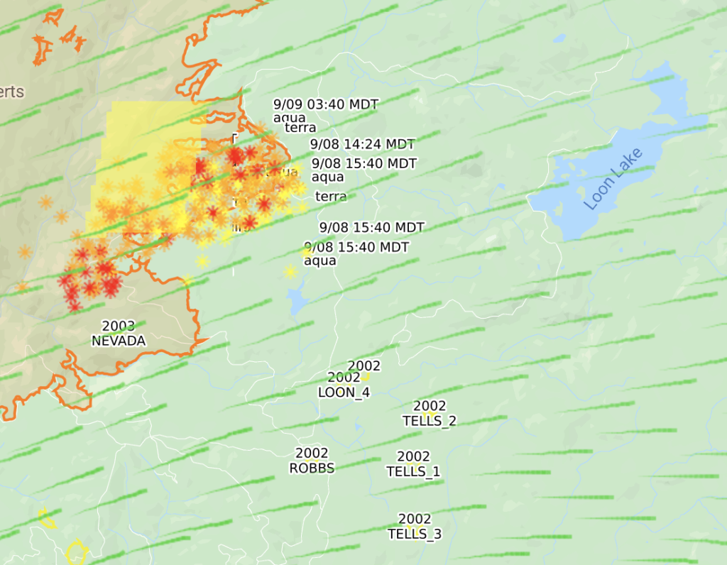
10:10a: Mapping the burn area, as detected by satellites, shows the fire close to 3,500 acres. Parts of it has jumped the Rubicon River, not sure if it’s established on the other side yet.
Camping prohibitions in place across Tahoe Basin. Also restricting day-use areas, campgrounds, and beaches.
Due to extreme fire conditions, emergency camping prohibitions are in effect across all National Forest developed recreation sites in CA, including CA/NV sides of the Tahoe Basin. Resorts, campgrounds, beaches, day-use areas, parking areas are closed until further notice. pic.twitter.com/0q6dH973LO
Due to extreme fire conditions, camping is prohibited in following areas of the Tahoe Basin until further notice: Meiss Country, along the Tahoe Rim Trail, Luther Pass, Watson Lake, Blackwood Canyon campgrounds. pic.twitter.com/7QCrSygvzz
8:15a: Fire still burning at 500 acres with 0% containment. Temperatures fell overnight and wind is currently around 10mph to the west, blowing the fire to a burn scar.
Smoke is down substantially from yesterday.
Satellite mapping shows the fire in the King Fire scar and active on the fire’s western front. Doesn’t seem like too much spread, though. Evacuations in place for the Upper American River watershed. I don’t believe there are many structures in the area.
8:45p
Fire is 500 acres with 0% containment. Winds have calmed down a bit but the area remains under a Red Flag warning through tomorrow. The fire is pushing into the 2014 King Fire scar.
2:35p PDT, Sept 8
The Fork Fire, which quickly jumped to 500+ acres, is burning near the burn scar from the 2014 King Fire. Wind is gusting towards that scar, which, with luck we haven’t had in 2020, may slow its spread. Aircraft not currently working on the fire, reportedly because of high wind.
2:01p PDT, Sept 8
Right as I posted the below, AA500 put the fire at 500-600 acres, well above the just-reported 100 acres. This thing is growing fast.
#ForkFire (El Dorado NF) – AA500 calling the fire 500-600 acres now. Fire is located about 3-4 miles west of Loon Lake looking @ their orbits.
Thanks for reading! Hoping to provide useful information about the Fork Fire. Would appreciate any coffee to listen to the scanner later into the night 🙂 https://www.buymeacoffee.com/rs44
2:00p PDT, Sept 8
Fork Fire up to 100 acres with “serious growth potential.” Evacuations for Loon Lake, Gerle Creek, and Rubicon trail.
The Fork fire is 100 ac w/ significant growth potential. Located off Wentworth Springs Rd. and the Gerle Creek access. E. of Gerle Creek, S. of South Creek Rd. Evacuations are in place for Loon Lake, Gerle Creek and Rubicon trail areas.
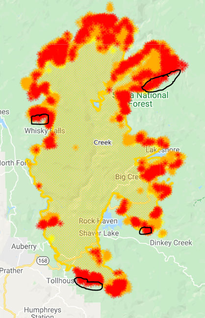
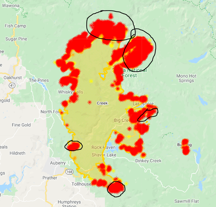
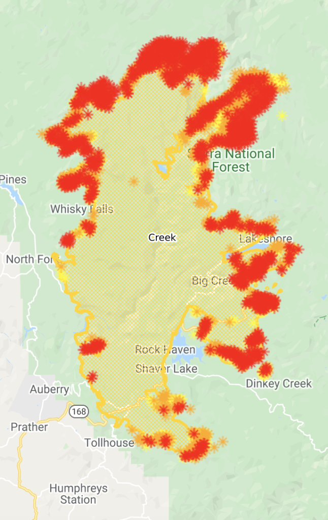
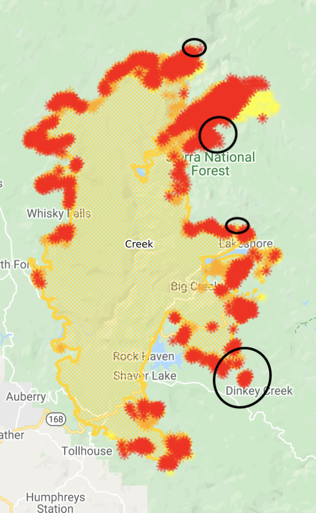
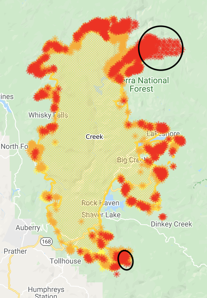
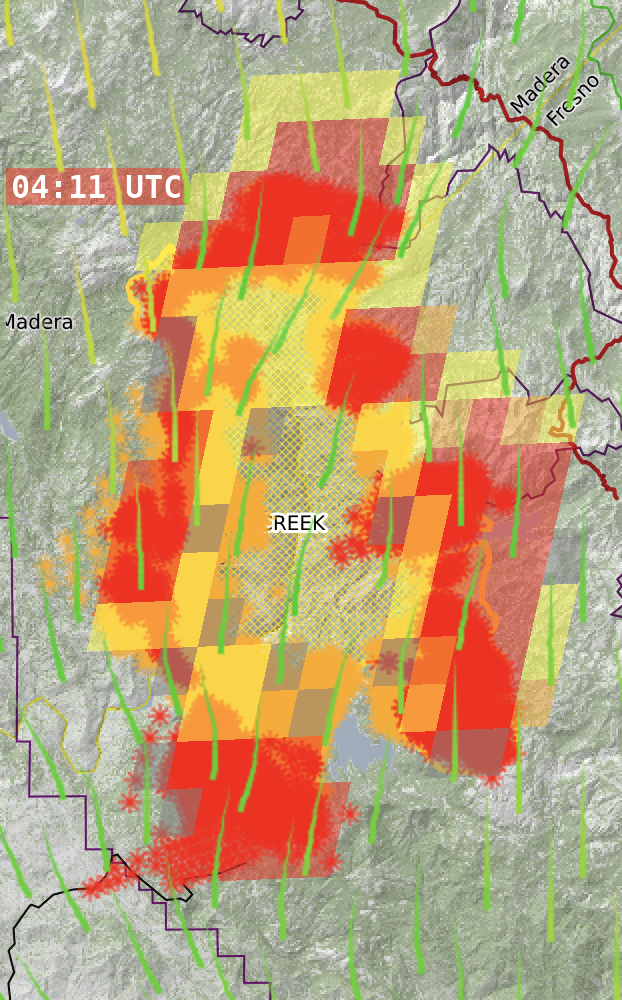
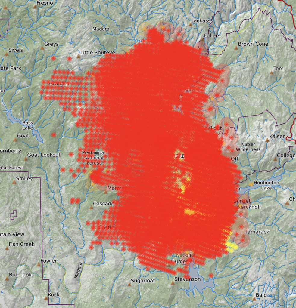
Fresno County: Active burning in the South Zone of the Creek Fire occurred during yesterday operational period south of Mount Tom progressing towards Portal Forebay. Active burning and torching occurred in heavy fuels and timber in this area. On the eastern portion of the fire progression was towards the east and on the south portion of the Zone it burned within control lines and consumed fuels interior to the existing perimeter.
Weather will follow the trend of season temperatures and low relative humidity with light winds, leading smoke to settle in the canyons and other low areas overnight into the morning with clearing by the midafternoon. Sunny skies will return Wednesday with little change in temperature or humidity and stabilize.
Fire progression may reach the Portal Forebay on the north portion of the Zone, and on the east portion of the fire it will progress towards the Dinkey Lake Wilderness. The southern portion of the fire should burn completely within and to the control lines from the burning operation. In high elevation areas with rock outcroppings, progression will slow. Smoldering will continue in heavier fuel loads such as timber and areas with dense fuel beds.
Operational priorities for today on the South Zone will include tactical patrol in all areas. Tactical patrol includes mopping up areas of the fire still exhibiting open flame, smoke and smoldering, and focusing on ensuring threatened structures are prepared for possible defense should the fire impact their communities. Additionally, line improvement and construction will remain a focus to improve containment of the fire with heavy equipment and hand crews removing additional fuels from areas around existing line.
Madera County: Weather conditions will continue to remain very consistent, possibly through the weekend. The alternating pattern of daytime up-sloping winds followed by nighttime down-sloping winds will be the dominant weather pattern. Fire crews have used this consistency and have implemented a very efficient routine and maximizing the use of air resources. Air Operations had a very busy day on the western perimeter of the fire near Central Camp. Helicopters performing water drops, and fixed wing aircraft dropping fire retardant along constructed dozer lines allowed for aggressive back-burning in this area. The fire has been brought around Central Camp utilizing these back burns, and confidence is high that this area will continue to be under control. Firefighters continue to patrol the cabins and to this point have protected the structures in this area.
Air reconnaissance was also used to visually survey the northern fire perimeter. After the fire spread last weekend over Beasore Road, this was the first opportunity to inspect the area including Granite Creek and Clover Meadows Camps. Fire preparations performed last week proved to be effective, and though the fire passed through these areas, the buildings in these camps were saved. Fire has also passed around Strawberry Mine, and the main buildings appear to be free of damage.
At its closest distance, the fire was measured to be about 14 miles west of Mammoth Lakes. The visual inspection verified that the natural barriers and the previous burn scar do appear to be limiting fire spread in the north-eastern flank.
Fresno County: The South Zone of the Creek Fire enters a critical period for the remainder of this week as winds will increase the next several days combining with other weather influences which may encourage fire growth. As a result, the operational priorities and objectives will focus on protecting at risk communities and infrastructure in the areas most likely to see fire growth.
While the lifting of the smoke inversion the next few days may allow aviation assets to deploy and assist with fire attack, it will also provide more preheating of fuels on south and southwest slope aspects in the zone. If the predicted winds develop this could result in increased fire activity, spotting, and spread into areas where the alignment of topography and weather are a potential. For this reason, direct attack, direct line construction, and active mop-up of all areas in the South Zone are prioritized for resources assigned on the fireline.
Crews assigned to the eastern perimeter are working to construct new fireline and improve existing fireline. Utilizing built and natural barriers, such as roads and existing topographical features, personnel are strengthening the line around the Rock Creek and Bald Mountain. Work progresses around China Peak to fully establish containment lines.
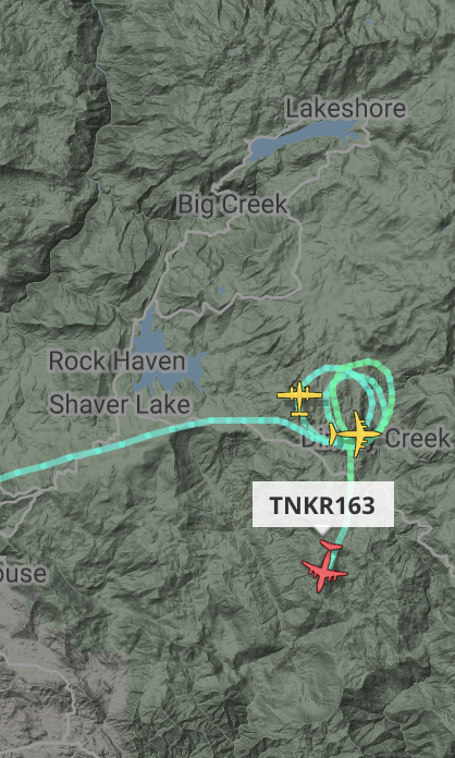
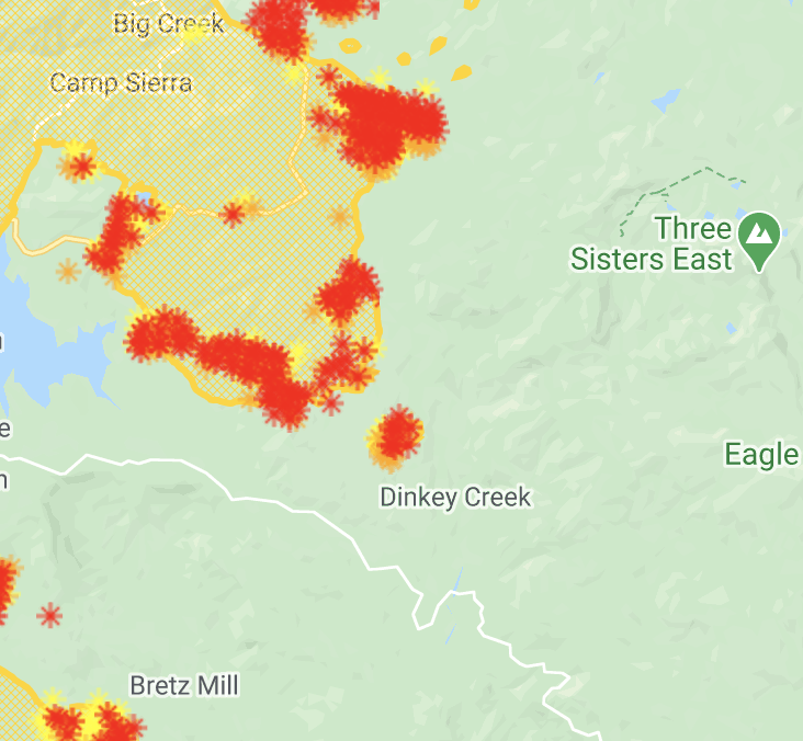
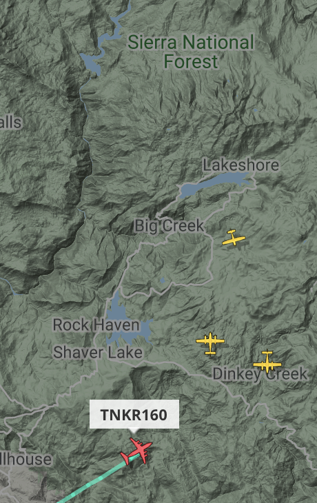
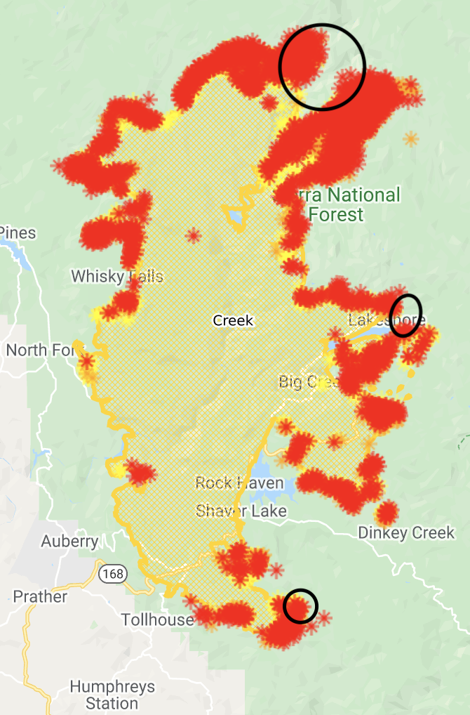
Near and around Shaver Lake structure protection is the operational priority as line south of the area is being constructed. If the fire moves east and north from the southernmost portion of the fire into Blue Canyon towards the threatened communities around Bretz Hill Rd, additional structure damage could be realized. Additionally, direct attack of open flame and aggressive mop-up continue in this area, and all areas around communities on the fire.
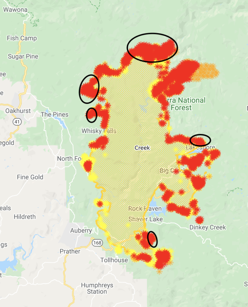
Madera County: Very dry air began moving into the region yesterday, along with increased winds and weakening of the inversion. These factors allow for increased fire growth along the north and northeastern flanks of the Creek Fire. Containment lines on the west flank were extended north from Cascadel Woods to an area just south of Peckinpah Meadow. Extension of containment lines has kept overall containment at 18% despite the fire spread. Very low humidity levels will continue today, with an enhancement of the upslope winds for these higher elevations.
Work continues on the west flank to fortify contingency lines and to protect assets such as Central Camp and the Bass Lake area. The tactics deployed in this area will provide options for our firefighting operations depending on how the fire reacts to the changing weather conditions in this area.
September 15
1:15p: Some evacuation orders downgraded to mandates.
9:45a: 220,000 acres (+8,000), 16% contained (-). Structures destroyed up to 555, rising because of increased surveying. 11,000+ still threatened.
From the morning briefing.
Fresno County: Today firefighters are preparing for a change in weather on the Creek Fire South Zone. Weather change brings changes in fire behavior. The fire has been relatively calm under the current inversion. That inversion will be lifting, bringing clear air, more heat to the vegetation and wind to the fire. Fire managers have reminded firefighters to “fight fire aggressively but provide for safety first.”
Holding line in the Jose Basin will be the primary priority today. Down canyon winds challenged that line last night. Even though there is still significant heat inside the line all control lines held. They will work to improve that line as well as the line around all the South Zone communities today.
Last night fire challenged a dozer line near Burrough Mountain. The mountain and nearby valley had been worked with air tankers yesterday to hold fire in check due to the potential of a run toward Tollhouse. To prevent this from occurring, a tactical firing operation is planned for that section of line. Firefighters have developed a plan to bring the fire to the dozer line when conditions are right for firing. This operation will remove approximately 5,000 acres of fuel between the dozer line and the current edge of the fire. This is also part of the project to button up Blue Canyon.
In Blue Canyon, where multiple dozer lines have boxed in the fire, firefighters have extended hose lines and will be mopping up the area closest to Shaver Lake and the surrounding community. As the weather change progresses, Blue Canyon will be aligned with winds that have potential to push the fire toward Shaver Lake.
On the eastern portion of the fire crews are working to contain and strengthen the perimeter control line. Several spot fires, including an 81 acre spot near Bald Mountain have been lined. Structures to the east of the fire are being wrapped with fire resistant material in preparation for the potential of fire spread to the east. Crews are also opening up Rock Creek Road to provide for a secondary line.
Last night, an 8-acre flare up occurred near Huntington Lake. This was within the perimeter of the fire. There are multiple island of unburned vegetation around local communities and withing the burn area. These are expected to flare up in the days and weeks to come.
Madera County: Estimated containment for the fire has increased to 16%, with the line in Madera County now extending from Redinger Lake to Mammoth Pools and Cascadel Woods. Firefighters remain in the area to patrol for hot spots. Crews continue extending line to Central Camp and points north as well as back-burning operations to secure perimeter. Standing dead trees, or snags, pose substantial safety hazards to firefighters in the area.
Work is progressing on clearing the 81 Road and Mammoth Pools Road within the fire perimeter. Utility companies are beginning to access the area to restore service. The Sheriff’s office has escorted several ranchers and bee keepers into the area to retrieve cattle and hives. Please visit the Sheriff’s website (QR code and complete web address below in yellow highlight) for current updates on evacuation orders and warnings.
The Forest Service announced a 1-week extension for the closure of National Forest Lands in California. The Sheriff continues to enforce county evacuation notices and maintain road closures to protect the public. Damage assessments are approximately 46% complete; the county will notify property owners directly as information becomes available.
Air quality is expected to continue to improve over the next few days. Air operations are resuming missions slated for today.
Creek Fire progression map.
Thanks for reading! If you’re interested in supporting the work that goes into providing these updates, please visit https://www.buymeacoffee.com/rs44. I really appreciate your generosity.
September 14
10:15p: 212,000 acres (unchanged) and 16% containment (+6pp).
Fresno County: Several evacuation orders in the Creek Fire South Zone downgraded today. Still, some 10,000 residents remain evacuated with structures at risk.
Fire burning northeast towards the Ansel Adams Wilderness. Spread should slow as it reaches rocky terrain. On the west side, the fire pushed through perimeter lines in the Jose Basin, threatening structures. Luckily, the run did not destroy any and, with shifting winds, firefighters constructed new control lines.
Madera County: Today saw a number of evacuation warnings lifted in Madera County: John West, Upper 426 road and China Creek.
Smoke hung over the drainages in the morning, but cleared in the afternoon, bringing increased fire activity. Current fire progression is to the north and northeast towards McCurry Trailhead, Jackass Meadow, Portuguese View Point, Globe Rock, and Little Shuteye Peak.
Overnight, the fire will also move continue moving towards Central Camp, South Fork Bluffs and Whiskey Falls.
Tough images coming from 168.
Down Hwy. 168 from Shaver, the Alder Springs area was hit hard. This area has been surveyed by @CAL_FIRE – you can use this map to see which structures have been destroyed/damaged by the #CreekFire: https://t.co/EefUXa3RTq
This isn’t before and after: Same road separated by less than a mile.
What strikes me most about #creekfire is the clear wind driven nature of it. Some forest sections untouched, then 1/4 mile down road total consumption of fuels. It def spotted miles ahead of itself. pic.twitter.com/m6P7HeTdGb
Thanks for reading! If you’re interested in supporting the work that goes into providing these updates, please visit https://www.buymeacoffee.com/rs44. I really appreciate your generosity.
3:40p: Getting some helicopter action over the fire on 168/Tollhouse Road.
3:00p: Some evacuation orders lowered to warnings.
Fresno County: Down canyon winds have increased fire activity in Jose Basin and pushed the fire across the line toward structures. This morning, firefighters are engaged in structure protection in the area. Later this morning, as winds shift to an up-canyon flow, fire crews will work to re-establish a perimeter control line and mop up hot spots.
Smoke over the fire has shaded the vegetation and decreased fire behavior over the last several days. Today, that smoke could clear at the higher elevations and lead to more intense fire activity which could include runs and spotting. With this in mind, fire crews have been scouting beyond the fire out to the east to locate structures and other values at risk. A plan will be developed for the protection of these resources in the event that fire does move to the east.
On the eastern perimeter dozers, engines and crews will be working to construct new line and strengthen existing fireline. In the Tamarack area crews are tying into roads and natural barriers between Rock Creek and Bald Mountain and working to strengthen lines around several spot fires in Tamarack Creek. Line is also being established around China Peak.
The northeast portion of the fire, where the smoke shading will have less of an impact, is expected to be the most active portion of the fire today. However, if smoke clears at the lower elevations there is a potential that fire in Blue Canyon could also make a run. With that in mind firefighters are working the perimeter and preparing structures around Shaver Lake.
One major concern is the potential for extreme fire behavior should the air become clear above the fire area. Clearing air will be an indication for firefighters on the ground that conditions are about to change. When the inversion over a fire begins to break up and the air starts to mix, it is very much like opening the flue of a fireplace. The smoke will begin to rise and pull fresh air into the fire, increasing activity. Firefighters are preparing for this possibility and will adjust tactics as necessary.
Madera County: The Madera County Sheriff lifted evacuation advisories for Zones M58 – M87, the general Highway 41 corridor between Road 200 and Bass Lake Road (also known as Road 222). Please visit the Sheriff’s website (QR code and complete web address below in yellow highlight) for current evacuation status. Firefighters are working to clear Road 81 and Mammoth Pool Road so utility companies can restore service before residents to return.
While dense smoke persists throughout valley bottoms this morning, winds from the south and southwest are expected to increase later this afternoon, potentially bringing a little fresh air to the area. Winds are expected to push the fire to the north/northeast.
On the north side of the fire, crews are focused on point protection, defending identified areas such as structures. Protection measures are in place at Devil’s Post Pile National Monument and Red Meadows. Fire suppression work continues on the west side; miles of line extend from Redinger Lake north to Cascadel Woods and Central Camp, with dozer line circling communities and many dispersed structures. Crews continue to back-burn between the containment lines and the active fire front, working to declare additional sections of the perimeter contained.
Thanks for reading! If you’re interested in supporting the work that goes into providing these updates, please visit https://www.buymeacoffee.com/rs44. I really appreciate your generosity.
8:15a: Creek Fire is now 212,000 ares (+10,000 overnight) and 10% containment. It’s burning hottest in the north, but there remain hotspots south and east of Shaver Lake. Up to 389 structures destroyed with damage crews about 30% through their assessment.
This map shows hotspots, with the recent ones circled.
Thanks for reading! If you’re interested in supporting the work that goes into providing these updates, please visit https://www.buymeacoffee.com/rs44. I really appreciate your generosity.
September 13
9:45p: 202,000 acres, 10% containment (up from 8%). It took the Rim Fire 13 days to reach 200,000; the Creek Fire did it in 9.
Recent hotspots to the east and north as the fire expands further into wilderness area. Air attacks today on the Dinkey Creek area, where there are cabins and other structures to defend.
1:15p: Things change fast in the air. Two tankers currently working in the Dinkey Creek area, looks like near a spot fire that’s a bit east of the main blaze.
12:45p: No tankers currently in the area, but an MD-87 made a few passes earlier and a 737 is on its way to Fresno from Santa Maria after first going to the Castle Fire/SQF Complex.
Some evacuation warnings lifted!
#BREAKING: Evacuation warnings have been lifted for portions of Madera County, that include the general Highway 41 corridor between Road 200 and Bass Lake Road, known as Road 222, according to @MaderaSheriff. #CreekFirehttps://t.co/Iyt4xtRnM2
Thanks for reading! If you’re interested in supporting the work that goes into providing these updates, please visit https://www.buymeacoffee.com/rs44. :I really appreciate your generosity.
10:45a: Tanker in the area, along with some recon planes.
9:45a: Fire is up to 202,000 acres (+5,000 since last night) with 8% containment.
Fresno County: Today the weather will transition and winds, combined with lower humidity and higher temperatures will begin to develop in the afternoon. The Creek Fire South Zone firefighters are working on multiple fronts that will become more active as the smoke clears. (Note that there is currently smoke being thrown from the South Sierra’s Castle Fire.)
A lot of work has been accomplished while the smoke layer has subdued the fire during the last four days. Crews will fight to hold and improve on that work today. They will focus on identifying and extinguishing hot spots around structures on the south of Huntington Lake, where firefighters engaged with a defensive firing operation that saved several structures. Fire also challenged the line in the area of Old Bretz Mill and Sierra Cedars. Firefighters held the line, preventing the fire from moving toward nearby structures.
The fire did burn over the line yesterday in Jose Basin on the southwest edge of the fire. Crews will work to pick the area up as it backs down the hill. They will also be patrolling around structures and mopping up any hot spots.
Line construction will continue in multiple areas. Construction of fireline between Shaver Lake and Dinky Creek is a high priority for fire managers as there is no suitable ridge to the east they can use as a contingency line. Fireline work will continue along Cherry Valley and into Blue Canyon where the fire could become aligned with the shifting wind a make a run. In the northeast the fire has been running along the North and South Zone dividing line for the fire. This finger of fire is burning in light fuels and moving toward natural rock barriers that will slow spread.
Madera County: The fire continues to push west toward Central Camp, challenging initial plans for containment lines in that area, but structure protection remains in place. Firefighters are developing and improving containment line on the west side of the fire from Redinger Lake north to Cascadel Woods and Central Camp.
Weather: Increasing winds are likely to begin moving smoke out of the north end of the fire, which is also expected to encourage fire growth to the northeast. Structure protection is underway on the north side of the fire, at Devil’s Post Pile National Monument, and Reds Meadows.
Air operations expected to resume with increased visibility. There have been conflicts between firefighting operations and drones. Do not fly a drone in the fire’s area.
Damage assessment in progress; see the map embedded above for updates.
Updated heat map here.
Thanks for reading! If you’re interested in supporting the work that goes into providing these updates, please visit https://www.buymeacoffee.com/rs44.I really appreciate your generosity.
September 12
10:15p: Creek Fire up to 197,000 acres and 8% containment (up from 6%).
Today’s activity in Fresno County: Northern portion of the South Zone had increased activity as smoke cleared at higher elevations. The fire made northeast runs in the Mill Creek and San Joaquin River drainage. It’s running into natural barriers and should slow soon after several days of growth in this area.
Smoke remained in lower elevations, but higher temperatures led to some increased action in the Old Bretz Mill area. Crews constructed direct fire lines and cleared fuels as the fire burned near structures.
The fire continued to back down Kaiser Ridge. It also continued working through Blue Canyon with occasional tree torching. The backing fire in Blue Canyon has contingency lines around it.
Terrain-driven winds tomorrow will clear smoke and continue moving the fire into deep canyons. This could affect Auberry, Shaver Lake, and Old Bretz Mill. Short range spotting will continue (there’s a spot fire in the Dinkey Creek area).
In Madera County, humidity fell to single digits, which contributed to active fire runs. The fire is expected to move north and east towards the Minarets.
Smoke will decrease in the next 72 hours with slope-driven winds shifting to afternoon up-slope winds as the smoke clears, except near the Sierra Crest. There, strong south to southwest winds are likely.
Increased fire activity likely in the North Fork Brown Creek, Central Camp, and Graveyard Meadows areas.
Map with hot areas circled.
10:40a: The fire is now 196,000 acres, up from 182,000 early last night. Much of that growth has come at its north and northeast fronts. There was some overnight activity on the north shore of Huntington Lake and south of Shaver Lake. I’ve circled the early morning hotspots.
And here’s information from today’s incident briefing.
Fresno County: Smoke stayed in the area overnight, dampening fire activity. Fire is still active in the South Zone. Pushing northeast towards the wilderness in the area south of Mammoth Pools.
Conditions improving in Auberry as firefighters make headway building line directly and indirectly on the fire’s edge from the San Joaquin River east to 168. They’re still working around structures to quickly identify hot spots and mop them up. That’s also taking place near homes at Huntington Lake and Shaver Lake.
There are seven spot fires east of Huntington Lake. Firefighters have lined all of them and will now extend hose lines around that spot fires to extinguish the remaining heat.
The fire is backing into Blue Canyon and today crews will determine how to address that situation. Because there’s so much dead and downed fuel, this backing raises concerns that the fire could further establish itself there and make a run into Shaver Lake from the south.
Firefighters will also be assessing a new spot fire in the area of Bald Mountain.
Madera County: Crews continuing to work on the containment line, moving north on the west side of the fire toward Central Camp. Dozers and hand crews are building the line while other firefighters have back-burned the area between the new line and active fire front. No firefighters have been injured to date during this incident.
Weather: The smoke has moderated temperatures and winds, keeping up-canyon winds lighter. This afternoon, though, the smoke will start to enhance winds near the Sierra Crest, gaining steam into Sunday. Winds will reach 20-25mph with gusts up to 40 along the northeast edge of the fire above 7,000 feet. Relative humidity will stay low.
Thanks for reading! If you’re interested in supporting the work that goes into providing these updates, please visit https://www.buymeacoffee.com/rs44.I really appreciate your generosity.
In Fresno County, smoke stayed over the fire, keeping behavior moderate to active throughout the day. On the southern end, the fire progressed with flanking and backing runs while on the northern end it had sustained slope runs. Main spread in the southeast and northeast. Focus remains on structure protection in Auberry and Huntington Lake. Line construction progressing in Blue Canyon – critical to protect Shaver Lake.
Meanwhile, in Madera County, the fire continues to burn actively above the smoke layer with low-to-moderate levels below the inversion. Smoke will remain in the area early tomorrow, keeping fire activity dull, but will clear later in the day with increasing winds. “Fire edge should remain in place from the San Joaquin River to Shuteye Lookout.”
From the satellites, here’s the hottest areas to burn recently.
Lots of destruction along Petersen Road. Most destroyed between Tollhouse and Cripes Road.
#CreekFire: This is quick look at some of the devastation left behind on Peterson rd in Fresno County. Nearly every home between Tollhouse and Cripe rd was destroyed by the inferno. More on the comments. @ABC30pic.twitter.com/V84Me3l2zs
Thanks for reading! If you’re interested in supporting the work that goes into providing these updates, please visit https://www.buymeacoffee.com/rs44.I really appreciate your generosity.
Thanks for reading! If you’re interested in supporting the work that goes into providing these updates, please visit https://www.buymeacoffee.com/rs44.I really appreciate your generosity.
3:55p: Local report is in the Creek Fire burn scar. Please DM him your address to see if he can check out potential damage.
Headed up to Shaver again to check on homes, cabins and businesses. Message me if we can help you get info on your residence. #CreekFire
8:30a: Fire burning hottest and most actively on its north end and at the south by Bretz Mill. Local reporters saying yesterday was a “turning point” as firefighters started to contain the fire. Milder weather will hopefully provide another productive day.
Here’s the operations map for September 11.
Very smokey conditions, which, unless it clears, will limit air attacks on the fire.
Thanks for reading! If you’re interested in supporting the work that goes into providing these updates, please visit https://www.buymeacoffee.com/rs44.I really appreciate your generosity.
September 10
10:05p: Local media again to the rescue. Further updates on damage. Credit to Fox26 News.
Jungle Town Lane
Badly hit
Orchard Ave
Trucks in back industrial area mostly lost
Huntington Lake Road opposite Point Drive
All homes lost
Mountain Juniper
Standing, but some damaged
Mountain Manzanita
Good
Mountain Cedar
All standing but some with damage
Upper Cedar
Good condition
Mountain Poplar
Cars in yard of 55145 destroyed
Parking garage across from Unit 204A lost
Mountain Spruce
Home between 55197 and 55123 is lost, but all others are good
Eastwood Lane
33114
Point Drive – The following are still standing:
Volunteer fire department
Post office
General store
FS1039
Community church
School and motel
55237
55240
55251
55263
55289
55388
55395
55396
55407
55408
55420
55419
55429
55430
Big screen Station
Southern California Edison power station is okay
Grouping of red houses with green roofs on south side of road leading into Big Creek is standing.
The FOX26 crew also checked homes along Auberry Road, west of the 168 up to Bald Mountain Road.
Due to time constraints, they were only able to survey the homes along the main road, and turned around at Bald Mountain.
If your house number is on this list, it is still standing:
45290
45250
45122 – burned but a shed or garage is still standing Jacobson’s 45032 – part of a building is standing but another is down
44888
44512
44448
44410
44465 – badly damaged but partially standing One home down the hill east of Alder Springs is standing. We couldn’t see the address
43119
42985
42969 – standing, along with a house behind it Mile High Park – standing but damaged
Thanks for reading! If you’re interested in supporting the work that goes into providing these updates, please visit https://www.buymeacoffee.com/rs44.I really appreciate your generosity.
9:30p: Fire is 176,000 acres and is 6% contained – the first containment on the blaze. Despite lacking aerial support because of poor visibility, crews made headway on building initial containment and dozer lines to protect unburned structures. They’ve been focusing on the southern end of the fire given its proximity to structures.
From the evening briefing:
Building bulldozer lines between Highway 168 and Jose Basin Road
Hand crews working in Burrough Mountain and Tollhouse Road
Dozers and hand crews working in Madera County to extend containment line from the San Joaquin River to Castle Peak
Attempting to keep fire east of Mammoth Pools Road by expanding old dozer lines and roads
Incorporating natural fire breaks (ie, rocky outcrops and open areas) into containment lines near Cascadel Woods
Dozer lines around the Marina View Community north to Bayshore Road
Ongoing damage inspection. Currently 361 confirmed structures destroyed, 60 of which were homes.
Went to get a feel for the damage in Big Creek today. There were some areas the fire completely swept through, right next to places that seemed untouched. I took a detailed list of the damage on every street – I’ll have that up on https://t.co/rGczlwMYhz shortly pic.twitter.com/LDioZwKgKA
Thanks for reading! If you’re interested in supporting the work that goes into providing these updates, please visit https://www.buymeacoffee.com/rs44.I really appreciate your generosity.
4:10p: Two tankers working from Auberry Road up to Reddinger Lake, largely along Jose Basin Road. First aerial activity all day.
3:30p: Local journalism is a treasure. YourCentralValley.com did an incredible job videoing their drive through numerous neighborhoods. Full site here, check it out. Summary below.
Radio Lane off Ringtail Lane: Structures look fine.
Merriman Lane near Ringtail Lane: Homes look fine.
Auberry Road past Pinecone Lane: Structures look okay.
44000 Auberry Road: Many structures destroyed with a few still standing on the road’s west side.
Alder Heights Road and Auberry Road: Most structures destroyed.
41000 Auberry Road: Many structures destroyed with a few still standing on the road’s west/south side.
Parts of Huntington Lake Road: Most structures destroyed.
Dowville East and West off Huntington Lake Road: Structures still standing.
Auberry Road, East of 168: Structures destroyed.
Near 45250 Auberry Road: Structure destroyed.
Near 45265 Auberry Road: Structures destroyed on the north side, standing on the south side of the road.
Bretz Mill: Structures currently standing.
Crest Point Lane loops to Ockenden Ranch Road via Musick Falls Lane: Structures standing.
Thanks for reading! Hoping to provide useful information about the Creek Fire. Would appreciate any coffee to listen to the scanner later into the night 🙂 https://www.buymeacoffee.com/rs44
3:15p: Some activity on the south side of the fire: Smoke column leaning over, throwing some spot fires ahead of it. Fire moving to, if not over, Soaproot Saddle. Air support requested, but air is too dirty right now. VLATs all parked at Sacramento. Three helicopters in the area and two fixed-wing recon planes.
Winds are blowing from the south/southwest. This could put pressure on Bretz Mill and, with increased fire activity, south shores of Shaver Lake and cabins in the Dinkey Creek area.
Thanks for reading! Hoping to provide useful information about the Creek Fire. Would appreciate any coffee to listen to the scanner later into the night 🙂 https://www.buymeacoffee.com/rs44
1:15p: Firefighters working to defend structures in North Fork, Cascadel Woods, and Bass Lake with dozer lines. The thick smoke layer and moderated weather conditions helping the fight on this western front.
Aerial crews currently grounded because of smokey conditions. They dropped 100,000+ gallons yesterday. There’s currently one lone plane over the Auberry and Tollhouse areas, flying at 12,000, probably mapping the fire’s boundaries.
Thanks for reading! Hoping to provide useful information about the Creek Fire. Would appreciate any coffee to listen to the scanner later into the night 🙂 https://www.buymeacoffee.com/rs44
10:15a: Smoke inversion in Madera County for much of the Creek Fire, leading to low-to-moderate fire activity under the smoke layer. Above it, fire remains active and intense in high fuel areas.
Wind has died down and will largely be terrain driven. Temperatures coming back to seasonal norms, though humidity is still lower than average.
There have been 361 structures destroyed with thousands still at-risk.
Growth coming through spot fires that find new fuels.
9:00a: The Creek Fire has grown to 175,000 acres. Overnight it made progress towards Dinkey Creek Road with some spot fires running ahead. Firefighters are concerned the two flanks snaking around Shaver Lake will connect and threaten Shaver Lake (again) and other structures in the Dinkey Creek area. They are working on existing fuel breaks to alleviate that concern.
Growth around Huntington Lake. It looks like, from the official map, that Lakeshore is still just outside the fire’s perimeter. Cedar Crest is inside the burn area, though no official word on structure toll there.
South flank of the fire, north of Tollhouse, slowly worked down ridges, firefighters trying to “pin it off” on a roadway.
West front growing and threatening structures near Bass Lakes. Air attacks laid a lot of retardant in that area, aided by some VLATs. Smoke lying low early, but they’re hoping it clears to enable more drops.
Thanks for reading! Hoping to provide useful information about the Creek Fire. Would appreciate any coffee to listen to the scanner later into the night 🙂 https://www.buymeacoffee.com/rs44
7:00a: Burned houses near Tollhouse at Petersen Road.
Thanks for reading! Hoping to provide useful information about the Creek Fire. Would appreciate any coffee to listen to the scanner later into the night 🙂 https://www.buymeacoffee.com/rs44
September 9
10:00p: Fire activity heavy on the west front today, slowed by aggressive aerial attacks assisted by large tankers. Overnight, firefighters are working to touch up existing fuel breaks south and south east of Shaver Lake to prevent the fire, which split around Shaver Lake, from rejoining.
Winds will be shifting to come from the southwest (forecast for 12-18 hours from now). There’s a renewed risk for Shaver has a flank of the fire has established itself below the town, driven by winds from the east, and could blow back onto it. It would be worse if the fire reconnects, hence the importance of reinforcing those fuel breaks.
Full video below.
FIRE MOVEMENT RIGHT NOW: Cal Fire says with winds shifting and coming from the SW Thursday… There’s a threat for the fire to come back up and threaten Shaver and the communities in the area. Here’s the plan to stop this and cut off the Creek Fire:#CAfire#CAwx#wildfirespic.twitter.com/zC4Ryymywz
Thanks for reading! Hoping to provide useful information about the Creek Fire. Would appreciate any coffee to listen to the scanner later into the night 🙂 https://www.buymeacoffee.com/rs44
9:00p: Combine a pandemic with dozens of wildfires – with more popping up daily – and you get stressed resources going above and beyond the call of duty. Incredible what firefighters have been able to do.
Cal Fire incident commander Nick Truax on the #CreekFire: "We have 1,300 firefighters on the line. This fire, under normal conditions, we would probably have anywhere from 3,000 to 4,500 firefighters on this incident…Historic times, take care of yourselves." @KQEDnews
7:30p: Fire 166,000 and 0% contained. Thankfully, it hasn’t grown much in size, despite fierce winds, after exploding to 150,000 acres.
Bass Lakes looks spared.
#BASSLAKE UPDATE: As of 6:30pm the area looks untouched by the #CreekFire. Smokey but no evidence of flames at least in the communities surrounding the lake. We will continue north toward Wawona and give an update when we can. @CBS47@KSEE24pic.twitter.com/VfK4TkqUWT
Unfortunately, the same can’t be said for the communities at Huntington Lake. Lots destroyed, but places close to the lake shore fared better. At least one neighborhood survived.
Here’s some of what @ZackHolmanKMPH and I saw in Huntington Lake today after the #CreekFire swept through. A lot destroyed, but a few places near the water are doing okay. Homes in the neighborhood with the sign pictured are still standing pic.twitter.com/LmduTcP3pH
Thanks for reading! Hoping to provide useful information about the Creek Fire. Would appreciate any coffee to listen to the scanner later into the night 🙂 https://www.buymeacoffee.com/rs44
5:40p: Lots of VLAT (very large air tanker) activity in the Meadow Lakes/Auberry Road area earlier. They put a hold on the activity about 50 minutes ago with the DC-10 able to complete its drop.
2:30p: Supertanker on its way. I believe I heard 10 minute ETA.
2:15p: Heavy fire activity by Jackass Campgrounds and Minarets Road, close to the Mammoth Pool Reservoir on the north side of the fire.
Thanks for reading! Hoping to provide useful information about the Creek Fire. Would appreciate any coffee to listen to the scanner later into the night 🙂 https://www.buymeacoffee.com/rs44
2:00p: DC-10 and other tankers launching air attack on the Creek Fire near Meadow Lake, working to protect structures there.
Thanks for reading! Hoping to provide useful information about the Creek Fire. Would appreciate any coffee to listen to the scanner later into the night 🙂 https://www.buymeacoffee.com/rs44
At least four homes in the West Village have been destroyed.
Shaver Lake FD doing structure protection. Sadly several of them lost their homes while battling the #CreekFire . Today they’ve already put out several hot spots in the area and are protecting homes… at least 4 homes in the West Village were destroyed. Live update at 5 & 6p. pic.twitter.com/lDqkMQKnRO
Littlefield threatened, currently protected by 80 firefighters.
Littlefield part 3 as of 11:30 am Wednesday. Hot spots in the area and around 80 firefighters. This area seriously threatened by the #creekfirepic.twitter.com/s2QoC33jNl
11:30a: Fresno Bee, citing firefighters, reports that some structures have been destroyed at Huntington Lake and China Peak. Strike team worked at Huntington yesterday; staff housing burned at China Peak but seems like most of the resort still intact, though it remains under threat.
Spot fire near Courtright Reservoir doesn’t seem to be growing, thankfully. Burning close to, if not in, the Dinkey Creeks Wilderness, by Three Sisters Peak.
Thanks for reading! Hoping to provide useful information about the Creek Fire. Would appreciate any coffee to listen to the scanner later into the night 🙂 https://www.buymeacoffee.com/rs44
8:05a: No major updates overnight, @CAFireScanner mentioned little activity on the scanners. 163,000 acres, 0% containment. Not expecting total containment until October 15.
Pine Ridge Elementary School still stands despite the fire raging around it a couple days ago.
Stunning image from rescue missions two nights ago.
200+ people and their pets were rescued thanks to the efforts of #NationalGuard Soldiers. The 40th Combat Aviation Brigade assisted in multiple flights through dense smoke and embers, making this mission one of the most challenging and dangerous that they have faced. #CreekFirepic.twitter.com/tBv9LyML0H
8:30p: Fire officially 160,000+ acres, 0% containment. Winds have generated spot fires as far as 10 miles away. At least 30,000 people have evacuated. 365 structures have been damaged.
Some structures have been damaged at the China Peak ski resort, but full destruction not yet known.
Crowning around China Peak will further decimate the forrest and risk uncontrolled spread.
Dangerous NE wind gusts have fanned large spot fires… Look at all the flames shooting up into the trees near China Peak along highway 168. pic.twitter.com/4sDzb5epoP
150 acre spot fire 10 miles away near the Courtright Reservoir, likely tied to the Creek Fire. No further updates on its growth.
#CreekFire (Sierra NF, Fresno/Madera Co) – The spot fire near Courtright Reservoir is 150 acres per AA who is now departing, tankers released for the night. Retardant has been put in @ bottom of the fire, they're hoping it runs into a rocky area.
4:30p: 30mph wind gusts expected tonight at Shaver Lake. Gusts up to 50mph around the Creek Fire.
Meanwhile, the battle for China Peak continues after the fire ran east.
North to northeast wind gusts near 30 mph are likely in Shaver Lake this evening into tonight. North to northeast wind gusts as high as 50 mph are expected in the vicinity of the #CreekFire this evening into tonight. This will likely result in extreme fire behavior. #CAwxpic.twitter.com/71w6BA8Ofr
Thanks for reading! Hoping to provide useful information about the Creek Fire. Would appreciate any coffee to listen to the scanner later into the night 🙂 https://www.buymeacoffee.com/rs44
3:50p PDT, Sept 8
There are no spare crews, and that might cause structure loss at China Peak. Thirty minutes ago, they could provide no backup despite the fire moving east to the ski resort. Now, at least, a strike team on their way, though it might be too late with structures in flames and a propane tank venting.
#CreekFire branch officer called for assistance 30 min ago, denied, no help available. Called minutes ago asking for more help as structure loss is in progress. Denied again. He has one crew (Laguna?) and little else. Winds kicking up. China Peak sounds like it's toast. GL guys. pic.twitter.com/PVj1G6RMyi
#CreekFire (Sierra NF, Fresno/Madera Co) – Fire @ the east end of Huntington Lake (Division R) is blowing out to the east, 1 trailer + 1 structure involved @ the Ski Resort (didn't say name but China Peak makes sense). No resources available to assist, may lose more structures.
Quick update on the earlier supply drop at China Peak.
#creekfire According to Scanner Traffic, GPS guided cargo drop at China Peak only marginally successful. 4 packages of 8 dropped, three recovered, one landed in fire, mission scrubbed after four packages dropped.
Thanks for reading! Hoping to provide useful information about the Creek Fire. Would appreciate any coffee to listen to the scanner later into the night 🙂 https://www.buymeacoffee.com/rs44
3:00p PDT, Sept 8
No fire update right now.
Here’s a video from a couple of days ago showing the Creek Fire plume collapse. The fire had generated a pyrocumulonimbus smoke cloud up to 50,000 feet. That monstrosity created its own weather patterns, including thunder heard at Huntington Lake and even some lightning strikes.
When that plume collapsed, it sent a massive amount of air downwards and then out, creating wind and extreme fire behavior. It’s the fire-created down burst, basically, that propels flames beyond the existing perimeter. This collapse further helped the Creek Fire grow.
Thanks for reading! Hoping to provide useful information about the Creek Fire. Would appreciate any coffee to listen to the scanner later into the night 🙂 https://www.buymeacoffee.com/rs44
12:30p PDT, Sept 8
From Governor Gavin Newsom’s press conference, the California National Guard rescued 164 people this morning. 17+ still waiting.
164 people were rescued this morning by @CalGuard helicopters. 17+ have yet to be transported. Below are images from @olenhogenson capturing some of the sweet reunions❤️
From scanner: Rescue operation at Edison Lake almost complete; “last load” leaving shortly, ~10 minutes!
Cancelling air drop of fuel to China Peak, instead bringing by road.
Thanks for reading! Hoping to provide useful information about the Creek Fire. Would appreciate any coffee to listen to the scanner later into the night 🙂 https://www.buymeacoffee.com/rs44
Cressman's General Store and Gas Station has been around since 1904. On Tuesday we learned the store was destroyed in the Creek Fire that has been burning out of control since Friday.https://t.co/LySNmAZhu3
Cressman’s, a staple by the four-lane for 114 years, burned down last night a little after 10:00 PM. I left the area at 10:04 PM and firefighters were spraying down the roof, trying to protect it, but had to divert as flames started roaring up higher.
Firefighters currently defending houses on Huntington Lake, but requesting additional support to fend off the fire. “This will be it later today.”
In some more good news, another National Guard rescue operation brought back 40+ people! That brings the total number rescued this morning up to 100.
8:50AM UPDATE: Another @CalGuard helicopter just landed with 40+ people and several dogs on-board. This is a largest haul this morning. This brings the total to nearly 100 rescued this morning. #CreekFirepic.twitter.com/aE3gyOUVYs
Fire is now nearly 144,000 acres, still with 0% containment. Maps show it pushing south/southeast overnight. 65 structures destroyed, 5,300 under threat.
Parking lot at China Peak currently “looks good” for bringing in cargo. Seems the shifting wind has cleared some smoke from the area, but as the firefighter noted, conditions change quickly.
Satellite showing the fire in Blue Canyon, where it attacked last night. Burrough Valley still looks (unofficially) fire free, but it’s very close. Tollhouse schools at risk, too.
Thanks for reading! Hoping to provide useful information about the Creek Fire. Would appreciate any coffee to listen to the scanner later into the night 🙂 https://www.buymeacoffee.com/rs44
8:10a PDT, Sept 8
Good news from overnight: After halting rescue operations for a few hours because of conditions, those stranded reported seeing stars, prompting new recon and three overnight rescue missions that rescued
-3 people from China Peak at 3:16a
-11 from Lake Edison at 4:44a
-11 people from Lake Edison at 5:42a
No word on how many remain stranded.
Three rescue flights from #CreekFire to Fresno Air Terminal over night. Cal Guard UH-60 Black Hawk, 13 people from China Peak, 3:16 a.m. Navy SH-60 Seahawk from Lemoore, 11 people from Lake Edison, 4:44 a.m. Cal Guard UH-60 Black Hawk, 11 people from Lake Edison 5:42 a.m.
Now for the bad news. Cressman’s General Store, open since 1904, burned overnight as the fire established itself south of 168.
While Sunday night was borderline miraculous from a building preservation standpoint, last night was just the opposite. High winds did exactly what was feared. This is the beloved Cressman’s general store near Shaver pic.twitter.com/jKFTPuhxxk
Thanks for reading! Hoping to provide useful information about the Creek Fire. Would appreciate any coffee to listen to the scanner later into the night 🙂 https://www.buymeacoffee.com/rs44
12:30a PDT, Sept 8
Signing off for the night. Winds look to be picking up a bit, still to the south. In the next 9 hours, forecast to shift a little to the west and rise to ~30mph in Tollhouse and ~40mph at Shaver Lake.
12:05a PDT, Sept 8
New from KCBS reporter Kathy Novak: Rescue operations for those stranded suspended until morning.
Breaking: the rescue operation at the #CreekFire has been called off for the night. Military helicopters have been unable to reach the people trapped in the hills. Will attempt the rescue again in the morning @KCBSRadio
65 structures have burned so far and another 5,000 are threatened. Auberry and Prather under evacuation advisements.
#BREAKING At least 65 structures have been destroyed by the #CreekFire. Fresno County has issued an evacuation advisement for residents of Auberry and Prather. https://t.co/U3jrM11O02
From scanners: Fire moving into Blue Canyon; firefighters verifying evacuation in the Burrough Valley and Sycamore Road. If you’re there, the fire is moving southeast fast – get out. Heed all evacuation orders.
10:25p PDT, Sept 7
Per scanners, the Creek Fire has jumped Highway 168 near Tollhouse and Cressman Roads and is trying to get established. Earlier mapping showed it on the highway (the polygons are roughly 1 square mile, so error involved there).
9:15p PDT, Sept 7
The fire sure looks bigger than 135,000 acres. Southerly winds have pushed the fire downslope and closer to more populated areas. From satellite detection and local media, it seems Huntington Lake is now surrounded and Shaver Lake might be, soon. There seem to be flares further down on 168 (note: This is all from fire overlays on CalTopo. Some might be controlled backburns; mapping could also be off).
Looks to be related to the #CreekFire. Radio traffic before indicated 36 people (was 25 before, just had another 11 turn up) were being sheltered in the Huntington Lake area, which has heavy fire activity on both the north & south sides. https://t.co/trnALtvntt
Meanwhile, news blazes popped up today in Oregon and Washington. One in WA has run some 90 kilometers in a single day.
Rapid growth of wildfires (black hot spots) as seen on shortwave IR. In the last frame or two it looks like a new fire has appeared west of the Cascades in Oregon, which is very concerning. pic.twitter.com/ue9p4g32h3
Bad news: 50 people remain stranded in three locations at China Peak and Lake Edison. A Chinook rescue attempt aborted after being unable to land amid heavy smoke. They will soon make another try with night vision.
Updated info on MCI event at FYI: rescue efforts were unsuccessful, military pilots tried valiantly to land but heavy smoke conditions prevented a safe approach, another effort will be made shortly to evacuate the trapped people in Lake Edison and China Peak using night vision.
This is the second military-assisted rescue mission in 48 hours, an event whose rarity Daniel Swain points out.
Before Saturday, I had never heard of military-assisted emergency nighttime wildfire airlift evacuations having happened in United States (certainly not on scale of hundreds of people). This is now second time it has happened in last 48 hrs…on same fire.#CreekFire#CAwx#CAfirehttps://t.co/A97nzISyqz
Worse news: The Creek Fire has its first confirmed fatality.
Fresno Fire officials & the Ca Army National Guard is getting ready to rescue 50-100 people trapped in China Peak & Lake Edison. They confirm 1 person has died , but don’t have a location at this time. @ABC30#CreekFirepic.twitter.com/vM8FMRAWAm
Last update for the night, and it’s a good one: Per scanners, no reported structure damage in the town of Shaver Lake. Videos of fires on the side of the road are back fires to keep the town safe.
8:45p PDT, Sept 6
Temperatures potentially slightly cooler tomorrow, but there’s a Red Flag warning in the area 2p-11p because of an offshore wind event. Consistent wind 10-15mph with gusts past 25mph. Those hot and incredibly dry winds means potentially extreme fire behavior and rapid growth. At 0% containment, hard to see how we don’t get another day of explosive rate of spread.
8:35p PDT, Sept 6
Just for comparison on how quickly this fire has grown, here are the day 1 and 2 acreage numbers compared to the Rim Fire, which ultimately burned around 250,000 acres. (Don’t read into this as the Creek Fire finishing exponentially larger; just an interesting comparison on initial sizes.)
Total Acres
Creek Fire
Rim Fire
Day 1
36,000
200
Day 2
73,000
250
8:15p PDT, Sept 6
Earlier today, Fresno County Supervisor Nathan Magsig said firefighters very nearly controlled the Creek Fire before it exploded. According to the Fresno Bee, Magsig said “When it was first discovered it was only 3 acres. Aircraft were deployed to knock the fire down. They thought they had it pretty well handled. It was knocked down to less than an acre. But within a matter of really just a handful of minutes the fire exploded and was up to 300 acres.”
Incredibly depressing to think of what could have been and almost was.
Meanwhile, satellite mapping and GOES 17 live fire detection puts the blaze around 160,000 acres. The experimental GOES 17 feature overlaid on CalTopo maps shows the fire in the town of Shaver Lake.
No official word on the town or confirmation from folks in the area. The GOES 17 feature is experimental and each polygon represents a mile or so in area. Hopefully it’s off and the fire hasn’t descended on neighborhoods.
Officials peg the fire at 73,000 acres and 0% containment.
4:30 PDT, Sept 6
New evacuation warnings in Madera County.
Evac Warning issued for Bass Lake Basin, surrounding area. Potential threat to life and property. Monitor situation, be prepared to take action immediately. Don’t wait for an order to leave if you feel unsafe. Those who are vulnerable and livestock owners should leave now. pic.twitter.com/xkilaeZG6p
Visual confirmation that the Creek Fire is in Shaver Lake. Smoke has covered the lake; flames lick its edges and burn to tree crowns.
The town is at the southern end of the lake – really, an artificial reservoir. Fire isn’t there yet, but is clearly on the move.
Brave videos and reporting.
Shaver Lake Marina surrounded in flames. Our @ABC30 crew has been told we cannot exit the marina parking lot. 168 is closed in both directions (towards the town of Shaver Lake and towards Huntington Lake) and it would be too dangerous for us to drive it right now. #CreekFirepic.twitter.com/5WsF5OtieD
Earlier today, the Creek Fire officially measured 45,500 acres. Fire activity as measured through satellite activity and mapped as a layer on CalTopo shows it closer to 150,000.
The maps shows it burning on Huntington Lake’s western end, north through parts of the Kaiser Wilderness and into Madera County, west past the San Joaquin River (which it jumped yesterday) to near Bass Lake, and south to the shores of Shaver Lake.
Zooming in there, satellites show the fire creeping towards the town.
Twitter users there report the fire at the Shaver Lake dam, moving slowly southward with crews working to douse any embers.
This is 100% false. Fire has NOT entered the town of Shaver as of this tweet. It’s at the dam moving south and they’re making a good stand right now. A lot of structure protection in place. Please don’t post false information. #CreekFire#ShaverLake
Currently, there are mandatory evacuations in place for: Shaver Lake down to Cressman, Big Creek, Huntington Lake, Camp Sierra, Florence Lake, Ward Lake, Portal Forebay, Edison Lake Mono Hot Springs, Kaiser & all campgrounds, and Cascadel Woods.
The Fresno County Sheriff’s Office has issued evacuation warnings for Cressman Road, Auberry Road from the top of the four lanes to Powerhouse to the San Joaquin River. Jose Basin, Alder Spring, Mono Wind Casino, Meadow Lakes and Mile High.
Highway 168 is closed 2.7 miles east of Prathers. There is no visitor access to the Shaver Lake area.
Yosemite National Park has issue a fire advisory south of Chinquapin, including Wawona. The Mariposa Grove of Giant Sequoias will close September 6 at 6p PDT.
Creek Fire Background
The Creek Fire started around 6p PDT on September 4 and within 24 hours had burned through 36,000 acres in Sierra National Forest. As of 1p PDT on September 6, that fire has torched nearly 46,000 acres and has 800 personnel working on the extreme blaze with 0% containment.
With California experiencing another severe heat wave, day time temperatures around the fire will be 90-95 degrees with very low humidity. Another day of explosive growth is likely.
Starting Monday, the season’s first offshore wind event – with Mono Winds bringing gusts well past 50mph – will further risk spread.
Evacuations and Road Closures. Mandatory Evacuations in place for the communities of Big Creek, Huntington Lake and Cascadel Woods. Hwy 168 is closed 2.7 miles east of Prather below the four lanes. Visitors are advised that there is no access to the Shaver Lake area.
I’m incredibly lucky to have gone to the Sierra Nevada for at least a couple days every year of my life – until 2020, that is, with the COVID-19 pandemic. It wasn’t until a few years ago, 2017, that I discovered just how much I love and yearn for the mountains.
And yet despite, an ever-growing desire to live in them, I’m stuck in Illinois, which surely must be one of the most boring states in the Union. Stuck by volition – a job and relationship – but stuck nonetheless.
Every so often some event makes me further question my decision to stay in a place I absolutely despise. Today, that’s the Creek Fire. Burning in Sierra National Forest to the west and northwest of Huntington Lake, the Creek Fire exploded to an official 36,000 acres in a day – and satellite heat maps show it burning closer to 150,000 acres.
The fire’s ripping through breathtaking scenery and potentially threatening more if – as – it makes its way north to Yosemite National Park. It’s also where I made my second Sierra trip (and first in the summer) outside of the Tahoe Basin, specifically, Desolation Wilderness. In 2018, my mother and I spent an evening near Shaver Lake on the east side of Bald Mountain and then dined at Shaver Lake. The next day we hiked, separately, to Kaiser Peak, from which I had my first glimpse of the distant High Sierra before looping through the forest, detouring to Nellie Lake, and making the way back to the trailhead through Mary’s Meadow.
That view of the High Sierra floored me. I spent hours in the coming days and weeks going through photos, trying to identify the unknown peaks, reading trip reports of them, studying maps for the first time….
I was in love.
Now the landscape around Kaiser Peak and Huntington Lake will be desiccated, scarred for generations. And this, on top of destroying beauty, threatening homes, perhaps taking lives (it’s already critically injured vacationers), reminds me: The Sierra’s beauty is fragile and increasingly at risk from climate change and instead of doing everything possible to explore those forests before coming droughts, bark beetles, and fires destroy them; Black Oaks replace Ponderosa Pines and other conifers; glaciers melt into cirque lakes, I’m languishing in Illinois.
And I hate that. So, so much.
It needs to change, but I guess I’m too scared to. I appreciate my job and don’t know if I’d find one out there (or a remote one). I don’t want to risk losing a relationship I value. But I can’t keep waiting and waiting and watching the Range of Light burn.