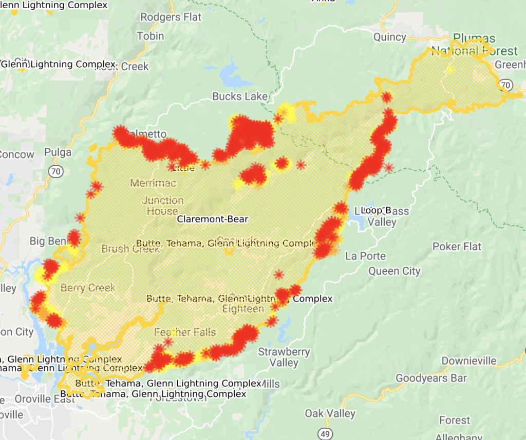
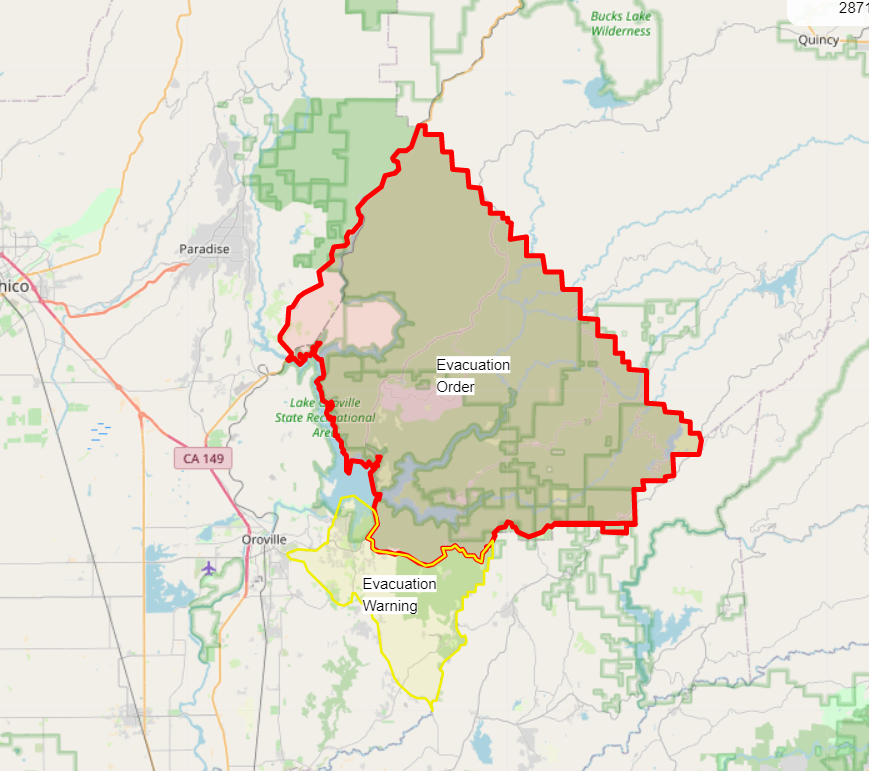
Bear Fire/Claremont Fire/North Complex Fire Evacuation Orders
This map shows current evacuation orders and warnings.
https://inciweb.nwcg.gov/incident/6997/
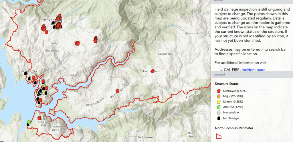
Structure Damage Map from CalFire
Bear Fire/Claremont Fire/North Complex Fire Updates
September 23
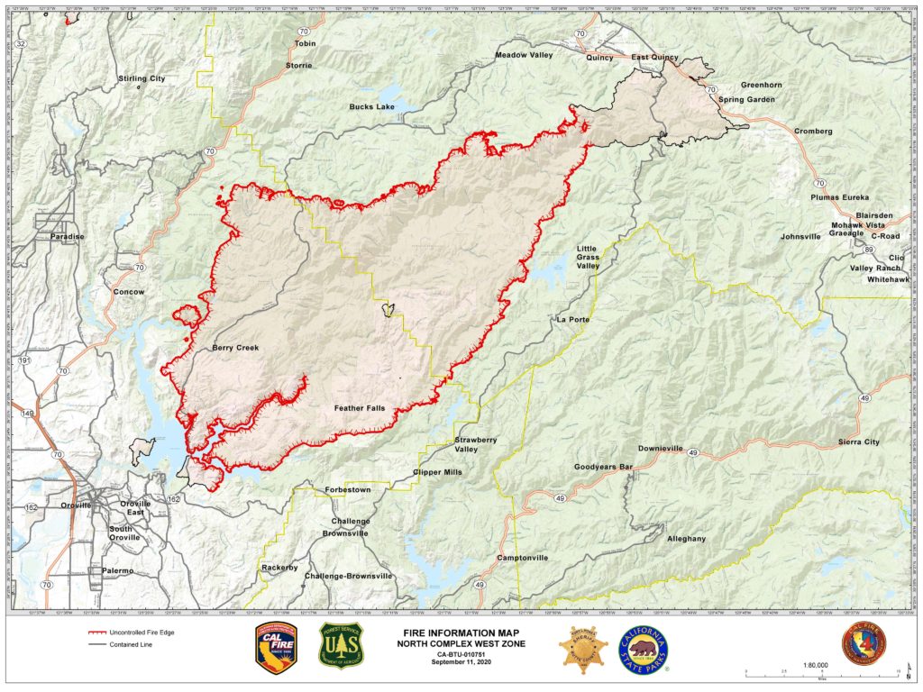
Complex is 301,000 acres and 75% contained. West Zone (the Bear Fire) is 82,500 acres and 63% contained.
South Zone: Overnight firing operations were successful around Quartz Hill and Onion Valley as crews were able to reinforce containment lines. Resources today will be focusing on monitoring these areas and looking to pick up any possible spot fires. Previously established south zone containment lines remain secured.
North Zone: Firing operations in the vicinity of Grizzly Big Creek to Grizzly Forebay were very productive last night. Crews completed firing to just south of Grizzly Forebay, where crews will look to complete firing during today’s shift. All slop over fires and spots have been picked up and will continue to be patrolled.
West Zone: Near seasonal temperatures remain, along with relative humidity values recovering to around 40 to 50% at night, and falling to around 25 to 35 % during the day. Smoke will continue to be a concern for weather, and air operations. Upslope and then upvalley winds will continue to be the theme during the day, with downslope and then downvalley winds at night. The winds are causing erratic fire behavior in the area of the South Fork of the Feather River drainage where most of the fire activity is taking place in the West Zone. The critically dry fuel moistures make the vegetation extremely receptive to fire. Change is expected to come this weekend and early next week which is expected to be hotter and drier with strengthening winds. A fire weather watch will be issued this Saturday lasting into early next week.
The fire continues to push to the west along the South Fork of the Feather River and has burned to and around the Ponderosa Reservoir. Check lines and tactical firing are taking place to slow the spread of the fire as firefighters aggressively construct more direct and indirect control lines to keep the fire from moving into the communities of Forbestown, Woodleaf, Clipper Mills and Strawberry Valley. In other areas of the fire crews are reinforcing direct firelines, mopping up, and conducting tactical fire patrols.
September 17
10:25a: Entire complex 281,000 acres and 36% contained; west zone is 78,000 acres and 35% contained. Total fatalities still 15 with 1 person missing.
South Zone: Due to increased humidity and lower temperatures, firefighters continued to make good progress gaining containment from Sly Creek Reservoir to Little Grass Valley. The fire remained active in the steep and rugged terrain of Onion Valley. Crews will also continue to construct indirect hand line along Fingerboard Ridge, a north/south ridgeline west of LaPorte Road. Containment lines along the northeast portion of the fire continue to hold.
North Zone: Priorities last night focused on containing spot fires, the largest of which is now approximately 200 acres on the northwest side of Red Mountain. Firefighters made good progress, and this area will continue to be the priority for resources today. Crews are working hard to contain the spots using existing roads, while also preparing indirect containment lines west to Oro-Quincy Highway
In the western portion of the fire, crews held the fire within containment lines and plan to continue preparing Oro-Quincy Highway from the Four Trees area to Big Bend, working west to the Camp Fire burn scar.
West Zone: Today there will be a cold front moving across the region making the airmass unstable and bringing stronger wind gusts. Strongest winds will be above 5,000 ft where gusts to 35 mph may occur. Lower elevations will see afternoon wind gusts up to 20 mph. Because of this there is a potential of erractic fire behavior on some parts of the fire.
Firefighters continue to fight to get into those areas of difficult access to make sure those areas of the fire are contained. The fire is burning in areas of heavy fuel loading, steep-rugged terrain intermixed with structures. Firefighters have been engaged in structure defense and constructing direct and indirect fire lines. View dozers at work here. Limited visibility due to smoke conditions has limited the use of fixed wing and helicopters to support ground personnel. The fire is actively burning in the South Fork of the Feather River with no known fire history over the past 100 years.
The utility companies have started working on the damaged infrastructure where safe to do so in the fire area. More work will continue as other areas of the fire are deemed safe.
September 14
10:50p: One additional set of human remains discovered. Total fatatlities is now 15. Two people still missing.
Complex is 265,000 acres (+4,000) and 39% (+9pp) contained. West Zone, formerly the Bear Fire, is 77,000 acres (+3,000) and 20% contained (+2pp).
From the evening briefing.
North Zone: Red Flag conditions tested containment lines today, however they held within the current perimeter. Resources in the most active areas of the fire made great progress today building containment lines from Lookout Rock down to Big Bend.
Despite red flag conditions, favorable winds allowed for a small firing operation earlier today at Four Trees to ensure the fire’s edge was kept in check, guiding it up to Oroville Quincy Highway. One 40-acre spot fire was caught on the north side of the highway by Frog Rock, but firefighters are confident they will contain it tonight.
Structure protection groups are in place surrounding the fire’s perimeter to protect nearby communities.
South Zone: Containment lines remained secure today while crews engaged in significant mop up work along Mooreville Ridge from Sly Creek Reservoir to Little Grass Valley.
With favorable winds and slightly clearer air conditions, two small strategic firing operations were executed along the north side of the Pacific Crest Trail (PCT) to Onion Valley, and in the extremely steep terrain of McCarthy’s Bar. During that small window of time when clearer skies allowed for aircraft to fly, two type 1 helicopters made water drops to support firefighters in these areas. Tonight if conditions allow, crews will continue firing along the PCT east to Chimney Rock, which will eventually tie into a small section of LaPorte Road (several miles north of the town of La Porte).
West Zone: The predicted gusty southwest winds and low humidity with periods of near critical fire weather conditions did not materialize as predicted today nor will it over the next two days. There will be an increase in temperatures but the humidity will stay relatively high. The smoke layer over the fire has started to disperse due to the slight increase in winds over the fire. Because of this, aircraft will have the visibility to be able to fly over the fire but the clearing of the smoke will have a negative effect on the fire causing the fire activity to increase.
Firefighters have been successful in strengthening several existing containment lines, developing new containment lines and extinguishing several interior hot spots in an attempt to prevent further spread. Firefighters continue to fight to get into those areas of difficult access to make sure those areas of the fire are contained. Several contingency fire lines are being developed as well.
Thanks for reading! If you want to support the work that goes into providing these updates, you can do so here: https://www.buymeacoffee.com/rs44. Thank you so much for your generosity.
Neat video of dozers creating a contingency line.
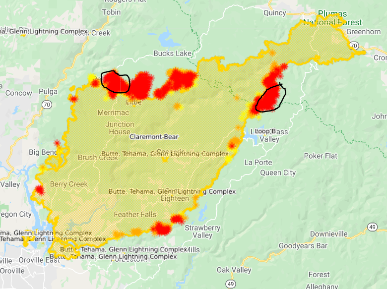
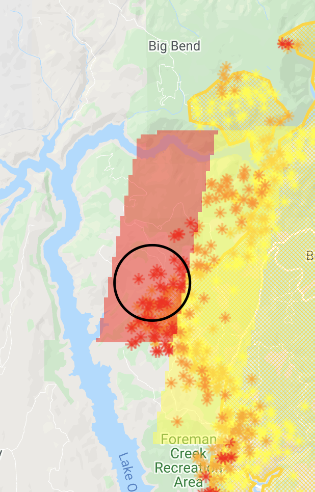
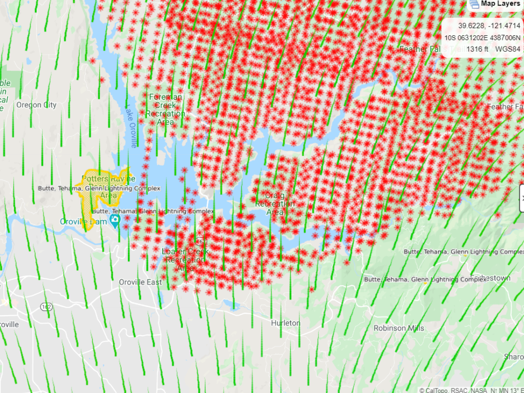
Newest heat circled.
10:10a: From the morning incident briefing.
North Zone: Firefighters were able to conduct night firing operations near Four Trees, and will continue to prep contingency lines off of roads in the area and on Red Mountain. Priority for firefighting resources remains the areas south of Bucks Lake where firefighters will work to secure all the progress made by night firing operations. Structure protection groups are in place surrounding the fire’s perimeter to protect nearby communities.
South Zone: Containment lines remained secure, while some interior islands of fuel burned in the steep terrain of the McCarthy’s Bar area. Firefighters were successful in working the fire’s edge along Mooreville Ridge to Sly Creek Reservoir.
West Zone: Firefighters have been successful in strengthening several existing containment lines, developing new containment lines and extinguishing several interior hot spots to prevent further spread. They will continue to fight to get into those areas of difficult access to make sure those areas of the fire are contained. Several contingency fire lines are being developed as well.
Last night, firefighters continued to prepare areas of the fire that will be impacted by the predicted Red Flag Warning with south west winds coming in on Monday, late morning, over the fire area.
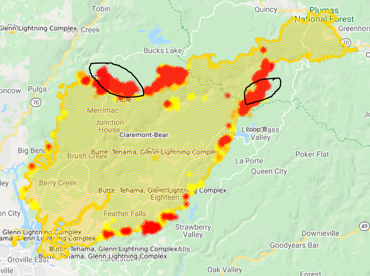
Recent hot spots, from satellites, circled.
Thanks for reading! If you want to support the work that goes into providing these updates, you can do so here: https://www.buymeacoffee.com/rs44. Thank you so much for your generosity.
September 13
10:10p: Two additional bodies have been uncovered, bring the total death toll to 14.
261,000 acres, 26% contained. The West Zone (formerly the Bear Fire) is 74,000 acres and 18% contained.
Red Flag Warning tomorrow with southwest breezes transition to downslope and down canyon winds with gusts up to 35mph. Minimum humidity near 15%.
From the incident briefing:
North Zone: Mop up continues around the northeastern perimeter of the fire, and lines continue to hold well. Thanks to cooperative winds, firefighters were able to continue protecting the Lookout Rock and Ontop Mine areas. Moving west, fire activity is more active and in rugged terrain. Crews were able to engage directly with the fire’s edge and mop up other areas, working toward their goal of tying into the 2018 Camp Fire scar.
Some spotting behavior did occur, however firefighters were quick to catch them. Night crews plan to revisit areas that were already fired to make sure they are complete and secure. Structure protection groups are in place surrounding the fire’s perimeter to protect nearby communities, taking extra care in getting through the incoming wind event.
South Zone: Firefighters made great progress today in improving and securing containment lines, and were successful in making the final connection between Little Grass Valley Reservoir south along Mooreville Ridge to Sly Creek Reservoir. In the extremely steep terrain near McCarthy’s Bar, crews were able to start firing operations which will eventually back into the main body of the fire.
West Zone: On the afternoon of September 8th, 2020 the North Complex fire entered Butte County with a vengeance, driven by extreme winds, heavy dry fuels, and steep terrain. The fire remains very active and now more than ever we need to remain vigilant.
Throughout the day, despite the lack of visibility, the weather continued be favorable with minimal winds, lower temperatures, and higher humidities, which enabled the firefighters on the line to accomplish several tasks and develop further containment lines.
Firefighters have been successful in strengthening several existing containment lines, developing new containment lines and extinguishing several interior hot spots to prevent further spread. They will continue to fight to get into those areas of difficult access to make sure that those areas of the fire are contained. Several contingency fire lines are being developed as well.
Due to the size, location, difficult access of this fire and predicted weather, the firefighters have a significant amount of work still to complete. Firefighters are prepping areas of the fire that will be impacted by the predicted Red Flag Warning with south west winds coming in on Monday, late morning, over the fire area. CAL FIRE Damage Assessment Teams continue the documentation of destroyed and damaged structures within the fire area.
10:15a: Operations update
North Zone: Fire activity was calm last night with humidity increasing and smoke laying over the area. Firefighters will continue firing operations today while conditions allow in the Lookout Rock and Ontop Mine areas. Crews will continue to secure what was already fired, with the goal of meeting indirect bulldozer lines where the 2018 Camp Fire scar is located. Structure protection groups are in place surrounding the fire’s perimeter to protect nearby communities, taking extra care in getting through the next incoming wind event.
South Zone: Fire activity was also calm last night in the south zone as firefighters worked to improve containment lines. Near McCarthy’s Bar, crews will continue scouting for the best opportunities to bring fire between ridgelines and current containment lines. Crews will continue constructing hand line from the west shore of Little Grass Valley Reservoir, moving south along Mooreville Ridge and Sly Creek Reservoir.
West Zone: Overnight the weather was in the firefighters favor with decreased winds, lower temperatures, and higher humidities, allowing crews to continue to aggressively fight fire and develop further containment lines.
Firefighters have been successful in strengthening several existing containment lines, developing new containment lines and extinguishing several interior hot spots to prevent further spread. They will continue to fight to get into those areas of difficult access to make sure that those areas of the fire will be contained. Several contingency fire lines are being developed as well.
Due to the size, location, difficult access of this fire and predicted weather, the firefighters have a significant amount of work to still complete. Firefighters are prepping areas of the fire that will be impacted by the predicted south west winds coming in on Sunday and Monday over the fire area.
New evacuation warning:
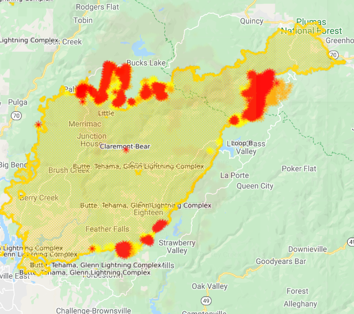
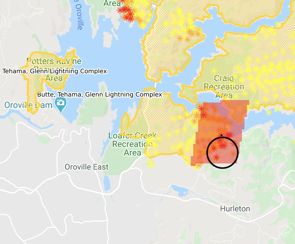
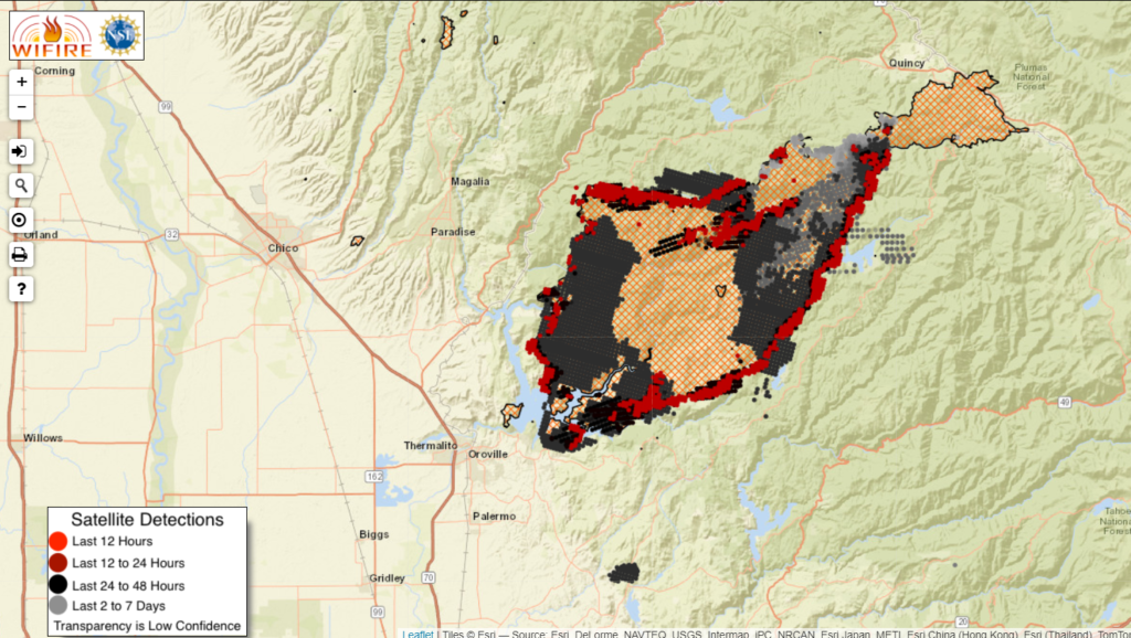
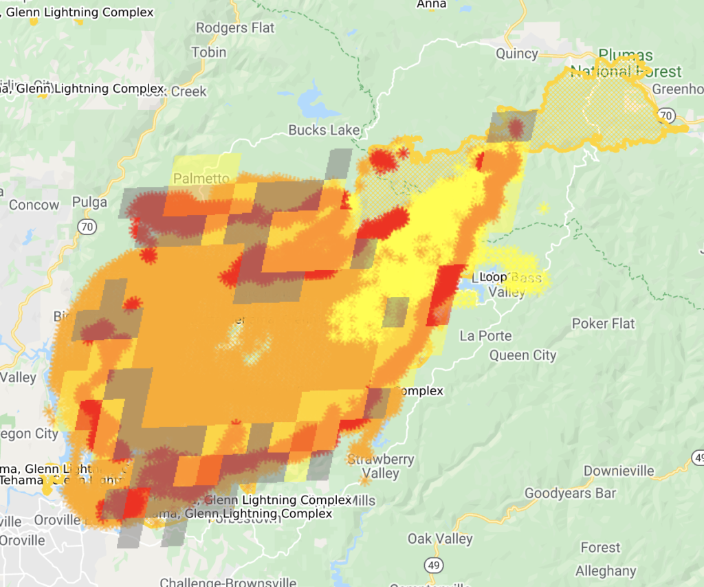
Updated map. Most of the red has burned hot in the last 12-18 hours.
Thanks for reading! If you want to support the work that goes into providing these updates, you can do so here: https://www.buymeacoffee.com/rs44. Thank you so much for your generosity.
September 12
10:45p: 258,000 acres, 22% contained. West zone is 73,000 acres, 10% contained.
Tragically, 12 people have died in the fire and an additional 13 are missing.
From the evening briefing:
North Zone: Firefighters continued gaining depth mopping up along the north and northeastern flank. Moving west, firing operations conducted today in the Lookout Rock and Ontop Mine areas will continue progressing tonight using indirect bulldozer lines to meet with the 2018 Camp Fire scar. Structure protection groups are in place surrounding the fire’s perimeter to protect nearby communities.
South Zone: Firefighters will work tonight to improve containment lines built today. Near McCarthy’s Bar, crews will continue scouting for the best opportunities to bring fire between ridgelines and current containment lines. Moving south, firefighters were successful in engaging directly with the fire’s edge. Tomorrow, they plan to continue constructing hand line around the west shore of Little Grass Valley Reservoir south along Mooreville Ridge and Sly Creek Reservoir.
Thanks for reading! If you want to support the work that goes into providing these updates, you can do so here: https://www.buymeacoffee.com/rs44. Thank you so much for your generosity.
11:15a: CalFire released a structure damage map, screenshot below. Fire is 252,000 acres and 21% contained. The North Complex West Zone (formerly the Bear Fire) is 72,000 acres and 7% contained.
From the AM update…
North Zone: Firefighters continued to make good progress on securing containment lines and there was no significant fire growth. Firing operations will be focused around the Lookout Rock and Ontop Mine areas. Structure protection groups continue to work in communities surrounding the fire’s perimeter.
South Zone: The most activity was located on the western side of Little Grass Valley, where firefighters continue to scout for opportunities to establish direct and indirect line construction.
Heavy smoke still blanketing the area.
Thanks for reading! If you want to support the work that goes into providing these updates, you can do so here: https://www.buymeacoffee.com/rs44. Thank you so much for your generosity.
September 111
11:55p: In slight good news, the number of fatalities has been reduced from 10 to 9: One of the bodies found was actually from an anatomical skeleton model.
Heavy smoke moderated fire activity throughout the day, helping firefighters.
In the north zone, firefighters continued working on a buffer zone to protect Bucks Lake, Haskins, and Highlands. The fire is currently 5 miles from the Meadow Valley and Tollgate areas.
In the south zone, the fire burned close to the west shore of the Little Grass Valley Reservoir. It’s still distant from structures. Community of La Porte is protected by fire lines and hose lays. 500 additional firefighters moving to a camp in Brownsville.
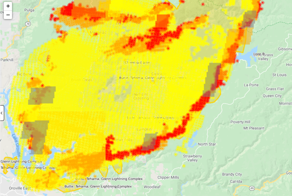
Updated fire map. Most activity on the periphery, but no substantial acreage growth as of this evening.
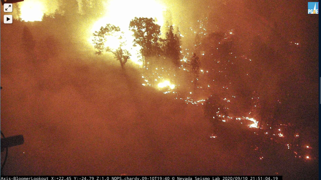
Here’s the fire from the Bunker Hill camera.
Thanks for reading! If you want to support the work that goes into providing these updates, you can do so here: https://www.buymeacoffee.com/rs44. Thank you so much for your generosity.
11:15a: Fire now 252,000 acres, 23% contained (the west zone, formerly the Bear Fire, is 70,000 acres and 5% contained).
Today’s updates from the morning briefing.
North Zone: Last night, crews detected and successfully responded to spot fires on the fire’s north edge. Today, crews will continue constructing lines to connect to Highway 70 in an area north of Elephant Butte and reinforce structure protection in communities.
Buck’s Lake, Haskins, Highlands, and Meadow Valley all currently safe (“no threat right now”) as firefighters “finished off” the fire in that area. Resources still there just in case the southwest winds push the fire in that direction. Mandatory evacuations there still in place.
Resources working Red Mountain to Oak Ridge. Past there, using road systems and contingency lines from the Camp Fire for containment lines.
South Zone: Crews have constructed hand and dozer lines with hose lays, utilizing existing roads to complete protection around the town of La Porte. Today, crews will continue to establish direct and indirect line and provide structure protection in the La Porte (dozer lines) and Little Grass Valley Reservoir areas. They’re hoping to build breaks west of La Porte Road, using it as a backup. Not too much activity in the fire there last night. Some activity around Little Grass Valley Reservoir, though infrastructure still stands.
“No issues” around Claremont Peak.
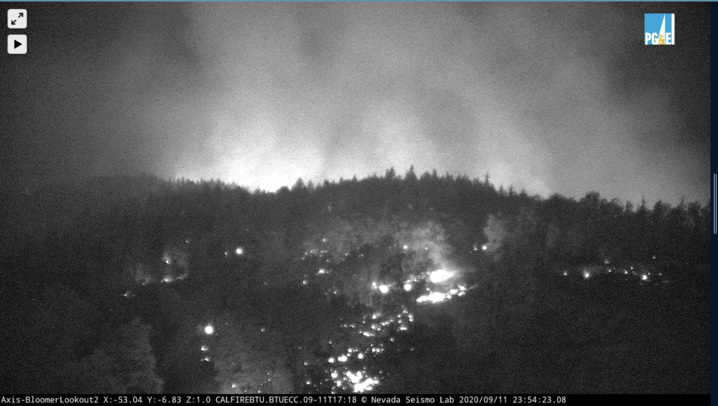
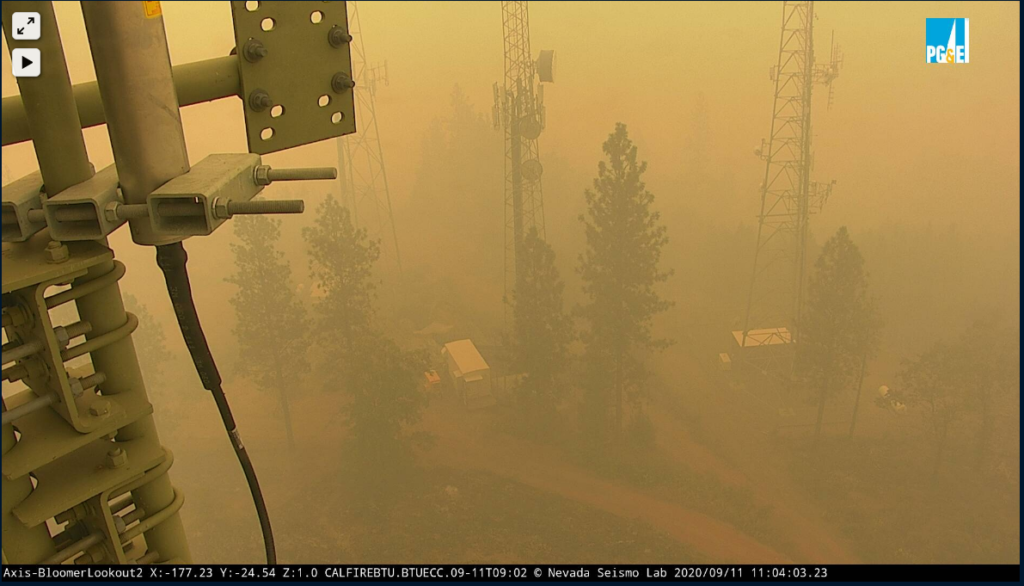
Threatened last night, the infrastructure at Bloomer Hill stands!
Thanks for reading! If you want to support the work that goes into providing these updates, you can do so here: https://www.buymeacoffee.com/rs44. Thank you so much for your generosity.
September 10
10:25p: From the official release, here’s where the battle stands.
North Zone: The fire remains in the current footprint from Lee Summit to Claremont Peak. Crews engaged with tactical firing operations near Lookout Rock; reinforcing structure protection in the Bucks Lake, Haskins, and Highlands areas.
They are prepping existing roads and building dozer lines to tie in with old fire scars and contingency lines from the Camp Fire. This will eventually tie in with Highway 70 north of Elephant Butte.
South Zone: Tonight, crews will continue to construct line along the Pacific Crest Trail and prep a series of existing roads south of Little Grass Reservoir to tie into La Porte Road.
Structures within the Little Grass Valley Reservoir area are not currently impacted or threatened by fire but are being prepped with structure protection and hose lays as a contingency.
Thanks for reading! If you want to support the work that goes into providing these updates, you can do so here: https://www.buymeacoffee.com/rs44. Thank you so much for your generosity.
10:15p: Seven additional fatalities confirmed, bringing total number to 10. Sadly, the missing 16 year old has been identified as one of them. 16 people missing (up from 12 yesterday).
2,000 structures destroyed, 23,000 more threatened.
9:55p: Firefighters actively defending structures off Springton Road by Maidu Run. Trying to stop eastern spread with dozer line between Maidu Run and Lothrop Lane.
The fire has also made its way to Bloomer Hill, as captured dramatically by ALERT cams. Important infrastructure here, so firefighters will be working to defend as best they can without reinforcements coming due to road blockage.
Thanks for reading! If you want to support the work that goes into providing these updates, you can do so here: https://www.buymeacoffee.com/rs44. Thank you so much for your generosity.
3:50p: Fire still burning off Shady Lane in the west Berry Creek area. A lone civilian fought flames there as his neighbor’s house burned. Crews activiely defending structures there and on Kelly Ridge. More information coming at 6:01p with the nightly press conference. No planes currently in the area.
1:40p: Tons of smoke in the area, limiting air activity. Satellite isn’t picking up new heat detections in the last 12 hours, a testament to cooling temperatures, decreased wind, and slightly higher humidity. Far from out of the woods, though.
Starting to get pictures of structure damage.
10:30a: Acreage revised down to 247,000; structure damage up to 2,000 (there’s been confusion over whether this number is 200 or 2,000). Winds died down Wednesday night after their gusts drove fire growth on Tuesday. Temperatures have also fallen and humidity has increased.
Firefighters spent Tuesday/Wednesday performing rescue missions. Now they’re focusing on containment lines to protection threatened population centers. They will also begin damage inspection.
Visibility remains low because of the smoke sitting in the area.
Desperate search still underway for a 16 year old last seen in the Berry Creek area, which has been destroyed by the fire. More info: https://sacramento.cbslocal.com/2020/09/10/search-josiah-williams-bear-fire-berry-creek/
Paradise lifting its evacuation warning for Zone 14, good news for an area that can’t catch a break.
The Bear Fire will now be known as the North Complex West Zone.
Thanks for reading! Hoping to provide useful information about the Bear Fire/North Complex Fire. Would appreciate any coffee to listen to the scanner later into the night 🙂 https://www.buymeacoffee.com/rs44
9:15a: Still 12 people missing. Of the three fatalities, one was found in a car, trying to flee the flames.
The mountain community of Berry Creek has been nearly destroyed by flames. Camp Okizu, a retreat for children suffering from cancer, has significant damage.
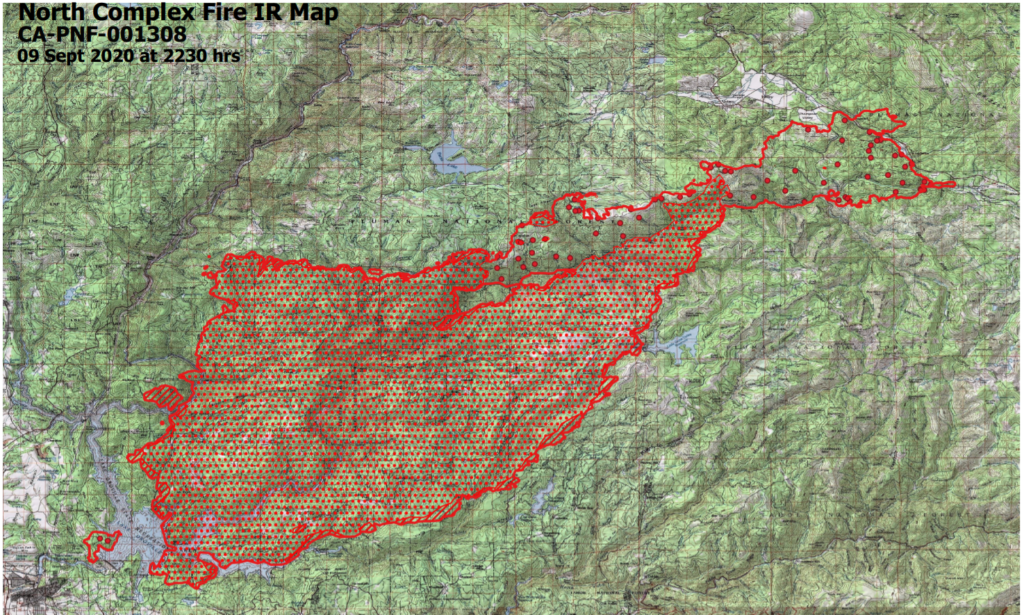
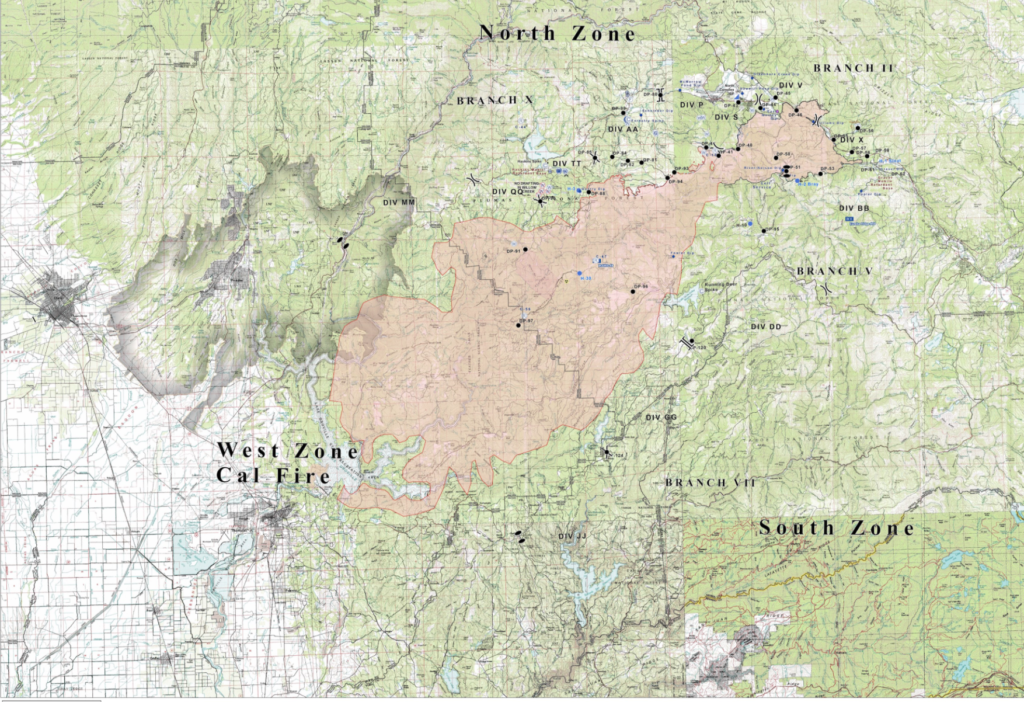
Official incident map below.
7:30a: 26,000 buildings at risk, at least 200 have been destroyed (on initial count). 1,300 firefighters battling the blaze.
Fire burning hottest at south and southeast (per GOES-17). Winds will shift to come from the south/southwest, which could threaten smaller communities currently to the fire’s east. Potential for extreme fire behavior where wind meets slope.
Thanks for reading! Hoping to provide useful information about the Bear Fire/North Complex Fire. Would appreciate any coffee to listen to the scanner later into the night 🙂 https://www.buymeacoffee.com/rs44
September 9
10:15p: 252,000 acres, making the North Complex Fire the ninth largest in state history. Most of that happened in a a single day when the fire jumped containment lines and ran to Lake Oroville. You can see that charge here.
Thanks for reading! Hoping to provide useful information about the Bear Fire/North Complex Fire. Would appreciate any coffee to listen to the scanner later into the night 🙂 https://www.buymeacoffee.com/rs44
The ops map for the fire (full resolution available here).
6:45p: Sad news from the press conference: Three confirmed fatalities in Butte County. 100 people have been rescued, the sheriff’s office is still looking for 12 more, and a preliminary count shows 200 structures damaged or destroyed.
Fire still east of Kelly Ridge. The winds yesterday – 45 mph – led the fire to jump its containment lines and make a 200-210,000 acre run. In a single day, the fire burned enough acres to be one of the largest 8 fires in California history.
2:10p: Six firefighters were sheltering off Lumpkin Road due to fire activity. They have since been rescued, one with a respiratory injury.
10:20a: New road closures: https://www.actionnewsnow.com/content/news/Northern-California-traffic-alerts-572217601.html?G4?G4
Satellite detection shows the fire almost surrounding Lake Oroville. Winds blowing south around 10mph.
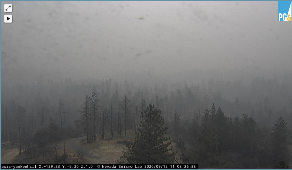
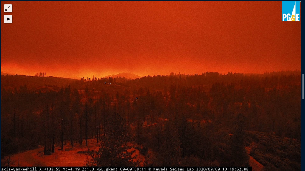
Here’s the fire from Yankee Hill. This image is from right now.
Bidwell Bar Bridge surrounded by flames.
More stunning images.
8:30a: Satellite heat detections show the North Complex Fire show the fire grew by around 250,000 acres in 24 hours, pushing hard to the south. This would make it the 7th or 8th largest fire in CA history, a standing achieved in just 24 hours. Those same maps show the fire threatening the town of Oroville and the Highway 70 corridor.
The fire produced a giant pyrocumulunimbus (fire thundercloud) overnight.
In good news, the civilians trapped by fast-moving flames all escaped.
Here’s the view this morning.
You can see the fire in the distance with the Camp Fire scar in the foreground. Paradise is close to the fire, but its movement to the south puts a little less pressure on the recovering town.
There’s a new fire, the Willow Fire, at the bottom of the above image, burning 300 acres.
September 8
10:30p: Lives at risk. This is currently the fire to watch. Follow local sheriffs, listen to evacuation order, be prepared to leave on a minute’s noticed when warned.
10:10p: Resources are stressed thin. If you’re in an evacuation zone, get out immediately – there might not be anyone to rescue you if things go south.
Fire jumped the Feather River, trapping 8-9 civilians.
Paradise, decimated by the Camp Fire in 2018, is just north of the evacuation zones and not currently in the direction of the fire. It could be at risk, though, with slight wind changes and further westward spread.
There has been some undergrowth since the Camp Fire and imperfect cleanup, meaning fuels are there.
Stay safe, keep updated on the fire’s movement, and leave immediately if you see flames.
9:15p: Great animation showing the tremendous fire growth.
9:00p: Fire has reached the east side of Lake Oroville, burning at Lumpkin Bridge.
8:50p: Forbestown will be threatened in the next couple of hours as the fire continues to spot some 2 miles in front of itself. The fire has run 25 miles today and may be approaching the east side of Lake Oroville. Continuing with a critical rate of spread.
40,000 acres have burned as the fire exhibits extreme behavior with a growing pyrocumulus plume reaching 40,000 feet.
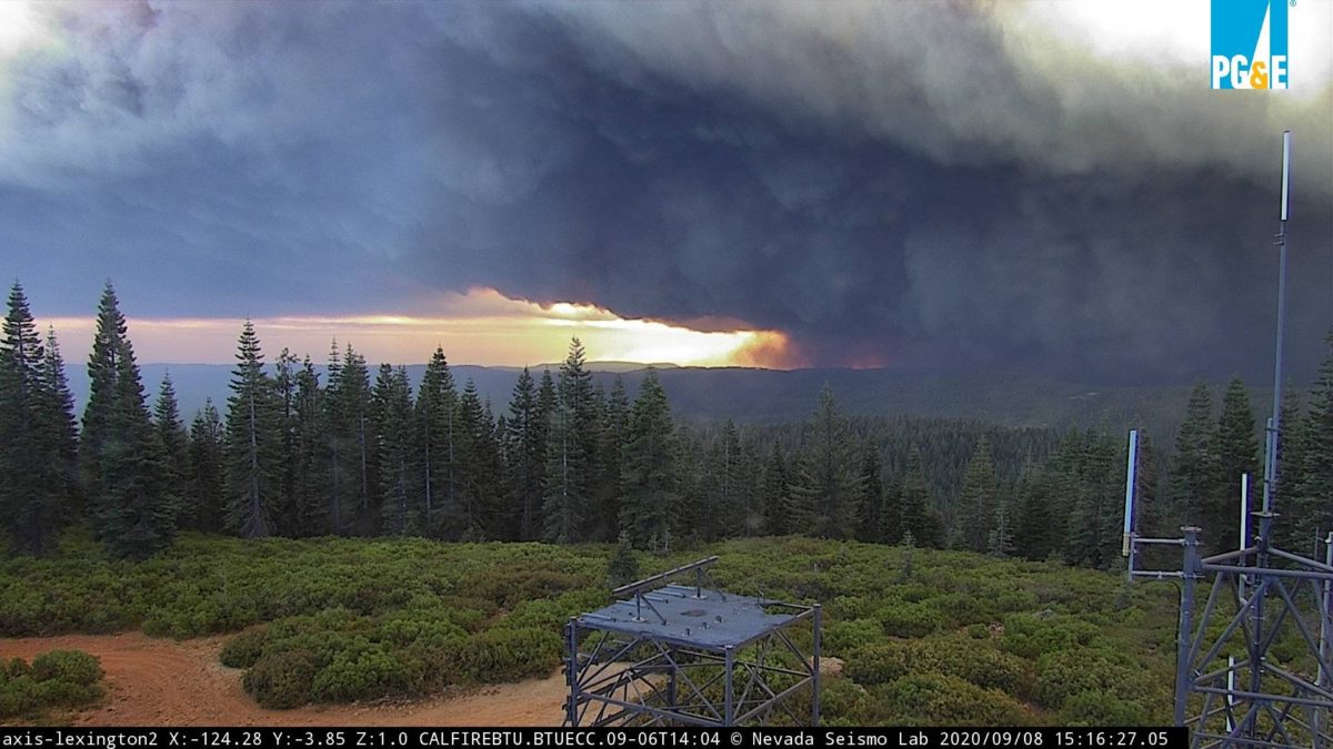
Stunning images come from ALERT cams.
3:30p PDT, Sept 8
Spot fires running ahead of the complex and rushing toward the community of Cascade. Heed all evacuation orders. Be ready to move, orders are coming fast.
3:20p PDT, Sept 8
The North Complex Fire has jumped containment lines established a few weeks ago when a lightning storm started the Claremont Fire. Driven by the offshore winds – some gusting to 60+ mph – the fire is racing southwest.
Daniel Swain, UCLA climatologist, likens it to the Camp Fire based on shape, smoke cloud, and vegetation ahead. The danger goes without saying. Be prepared to evacuate, listen to orders, and get out if you see flames because the fire is moving fast.
Also risk of a plume collapse, which could accelerate the fire’s spread and cover a vast area in smoke.