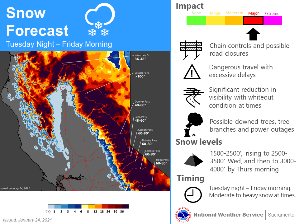
The above image, courtesy of the National Weather Service Sacramento office shows the expected snow totals from the upcoming atmospheric river, drenching the state from Tuesday night through Friday morning. Needless to say, it’s a lot, especially on the heels of record dryness that prompted elevated and critical fire conditions in mid-January.
In fact, should the storm hit those snow at the Sierra passes, it will single-handedly push snow depth well past the various averages for January 29, according to daily SNOTEL data for Donner Pass, Echo Pass, Carson Pass, and Ebbetts Pass from roughly 2004 to 2020.
Tabular data below. Raw snow depth (now snow-water equivalencies) in inches. Storm number takes the lower end of the forecast.
| Donner Pass | Snow Depth |
| 1/24/2021 | 32 |
| Storm | 48 |
| 1/29/2021 | 80 |
| Average | 57 |
| Echo Pass | Snow Depth |
| 1/24/2021 | 37 |
| Storm | 48 |
| 1/29/2021 | 85 |
| Average | 60 |
| Carson Pass | Snow Depth |
| 1/24/2021 | 29 |
| Storm | 60 |
| 1/29/2021 | 89 |
| Average | 57.25 |
| Ebbetts Pass | Snow Depth |
| 1/23/2021 | 31 |
| Storm | 60 |
| 1/29/2021 | 91 |
| Average | 60 |
There will also be some smaller snowfall coming in the next 7-10 days before the likelihood for looming dryness returns. Obviously, the next few days will be crucial to overcoming the current snowfall deficit.